
Rannoch Hydroelectric Power Station


Hydroelectric Power Station (20th Century)
Site Name Rannoch Hydroelectric Power Station
Classification Hydroelectric Power Station (20th Century)
Alternative Name(s) Loch Rannoch; Rannoch Hydroelectricity Scheme; Tummel Hydro Electric Scheme; Ardlarach
Canmore ID 105929
Site Number NN55NW 11
NGR NN 53008 58278
Datum OSGB36 - NGR
Permalink http://canmore.org.uk/site/105929


- Council Perth And Kinross
- Parish Fortingall
- Former Region Tayside
- Former District Perth And Kinross
- Former County Perthshire
NN55NW 11.00 5300 5828
Rannoch Power Station [NAT]
OS 1:10,000 map, 1977.
NN55NW 11.01 NN 5294 5910 valve house
Field Visit (2010)
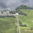
This powerhouse generates electricity utilising water from Loch Ericht (see separate record form dam). The station was initially equipped with two Francis type turbines designed for the conditions under which it would operate. Rannoch station was a major component in baseload supply for the Grampian region, and as a result the thermal plant at Abernethy was closed down. The site underwent redevelopment in 2000 including new turbines. This is a significant example of the use of Hydro for large scale public supply, with the capacity for baseload generation. The classical design of the exterior of the building is similar to that at Tummel Bridge, with some original features such as control panels and turbines retained to the interior. One of a pair of powerhouses in the scheme of similar design (see Tummel Station). The Rannoch / Tummel scheme is distinct from the Falls of Clyde scheme (which predates it) because it uses different technology as a reservoir scheme instead of a run-of-the-river development. P L Payne,1988; Emma Wood, 2002; J Miller, 2002.
Note (25 October 2023)
The Tummel-Garry hydroelectric power Scheme
The second of the Hydro Board's schemes was an extension of the Grampian Electricity Company's scheme. The Clunie Dam was constructed at the east end of Loch Tummel, increasing its size. A tunnel connects to Clunie power station below the Falls of Tummel. A dam was built at the east end of Loch Errochty whose water was fed by a tunnel and pipeline to a power station at the head of Loch Tummel. Finally, the River Tummel was impounded at Pitlochry forming Loch Faskally. The power station here is built into the dam and incorporates a fish ladder to allow salmon to pass. Loch Faskally forms a balancing reservoir for fluctuations in flow due to the Clunie power station's operations.
The scheme produces a total of 150,000 kW. Work started in 1946 and experienced similar problems to Loch Sloy due to shortages of labour and material, being completed in 1951.
This account relates to the Scottish Hydro collection of photographic images held at HES, Edinburgh. Compiled by a volunteer, Mr George Walker in 2005.
Information from HES (Miriam McDonald), 25 October 2023.

