
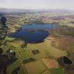
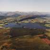
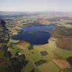
Dog Isle


Crannog (Period Unassigned)
Site Name Dog Isle
Classification Crannog (Period Unassigned)
Canmore ID 87720
Site Number NN50SE 72
NGR NN 5676 0027
Datum OSGB36 - NGR
Permalink http://canmore.org.uk/site/87720


- Council Stirling
- Parish Port Of Menteith
- Former Region Central
- Former District Stirling
- Former County Perthshire
NN50SE 72 5676 0027.
NN 567 002 No structural remains can be seen on the Dog Isle today. Underwater examination of the island suggested that it is at least partly artificial - consisting of boulders capping an existing natural feature. Most revealing was the discovery of two Quercus timbers at a depth of 1.7m embedded into the island. One of these timbers was recovered as it demonstrated evidence for tool facets. (See NN50SE 5 for possible association with the castle on Inch Talla.)
J C Henderson 1994.

