
Dalwhinnie - Fort Augustus Military Road


Military Road (18th Century)
Site Name Dalwhinnie - Fort Augustus Military Road
Classification Military Road (18th Century)
Alternative Name(s) Corrieyairack Pass
Canmore ID 83034
Site Number NN49NE 4
NGR NN 4800 9562
NGR Description NN 4999 9532 to NN 4500 9646
Datum OSGB36 - NGR
Permalink http://canmore.org.uk/site/83034


- Council Highland
- Parish Laggan
- Former Region Highland
- Former District Badenoch And Strathspey
- Former County Inverness-shire
NN49NE 4.00 from 4999 9532 to 4500 9646. MR 4 (formerly Lin 504).
NN49NE 4.01 4674 9594 Bridge.
NN49NE 4.02 4599 9619 Ford.
NN49NE 4.03 4510 9643 Bridge.
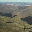
The military road heads W along the N side of the River Spey in typically long straight stretches as far as Melgarve. In the section leading to the Allt Feith a' Mhoraire, just E of Melgarve, are two culverts displaying signs of having been originally of Wade construction, although having modern work on top. This stretch of road is passable by car as far until the Allt Feith a' Mhoraire, where a wooden bridge (NN49NE 4.01) spans the burn at NN 4674 9594. This bridge and some of the road on either side of it are not of Wade's construction. His bridge (NN49NE 3), well preserved, survives 200 yards upstream of the wooden bridge at NN 4687 9609 in a section of forestry, but visible from the road. There are no traces of the approach road, which probably left the present road at about NN 477 958, where the forestry commences, re-joining it at Melgarve, having passed behind the hillock W of the forestry. This route is on a straighter course than the present one. A majority of the Corrieyairack burns were bridged by Wade, all of these bridges surviving either in their entirety or in part.
At Melgarve, a track, possibly linking this road with the Fort William to Inverness military road (MR 1), branches off to the SW, taking a route by Loch Spey and over the col into Glenroy and from thence to Fort William. The Wade road maintains a line to the NE of the Allt Yairack, ascending steadily towards the summit of the Corrieyairack as a rough but easily walkable track.
J B Salmond 1938; W Taylor 1976; J and A Baker 1982.
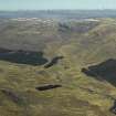
The military road is now overlaid by tarmac as far W as Melgarve. A modern track then heads NW from the bridge (NN49NE 4.01) at NN 4674 9594, deviating round a restored single arch military bridge (NN49NE 2), which lies across the Caochan Riabhach at NN 4634 9611. The burn is now crossed by a large concrete pipe. A short distance to the W the remains of banks are visible. A ford (NN49NE 4.02) takes the track across the Caochan Ban at NN 4599 9619. This modern construction consists of large flat boulders, but it is now falling into disrepair. A short distance NW of the Caochan Ban is a section of recent re-metalling, with two modern stone drainage channels inserted into the fabric of the track. Next to this area a faint trace of what may be an early back ditch is visible about 4m from the side of the road. The road then crosses the Allt a' Mhill Ghairbh at a natural fording point, having deviated around the remains of a bridge (NN49NE 4.03) at NN 4510 9643.
M Logie (Highland Council) 1997; NMRS MS 1007/4.
NH 374 071 - NN 462 961 A watching brief was maintained over the Dalwhinnie to Fort Augustus military road or Corrieyairack Pass, focusing on the section from Fort Augustus to Melgarve which is a Scheduled Ancient Monument (NMRS NH30NE 21, NH30SE 2, NH39NE 2, NN49NW 2, NN49NE 2-4). The road was being used for the refurbishment of an electricity pylon line.
No archaeological features or deposits were revealed by groundworks. Protection was made to features that might be disturbed by work by placing of terram material.
Report lodged with Highland SMR and the NMRS.
Sponsor: Scottish Hydro-Electric plc.
S Farrell 1999
Watching Brief (20 June 2011 - 6 October 2013)
A watching brief was conducted between June 2011 and October 2013 for upgrading of access on the Corrieyairack Pass, which included the importation of material and drainage and repair works. Work revealed limited archaeological features to the area of the road, the road has seen extensive damage in parts due to flooding and erosion.
The following unrecorded sites are adjacent to the road:
- Sheepfold at NN 46942 959606
- Enclosure and Cairn at NN 45074 96420
Full Report submitted to Highland SMR and NMRS
Funder: Speyside Trust
Struart Farrell

