
Dalwhinnie - Fort Augustus Military Road


Military Road (18th Century)
Site Name Dalwhinnie - Fort Augustus Military Road
Classification Military Road (18th Century)
Alternative Name(s) Corrieyairack Pass
Canmore ID 83033
Site Number NN39NE 2
NGR NN 3985 9981
NGR Description NN 3999 9963 to NN 3971 9999
Datum OSGB36 - NGR
Permalink http://canmore.org.uk/site/83033


- Council Highland
- Parish Boleskine And Abertarff
- Former Region Highland
- Former District Inverness
- Former County Inverness-shire
NN39NE 2 from 3999 9963 to 3971 9999.
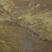
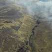
The military road continues the descent from the Corrieyairack Pass, heading NW to the E of the Allt Coire Uchdachan.
J B Salmond 1938; W Taylor 1976; J and A Baker 1982.
The military road continues as a walkable track in reasonable condition, although there are occasional heavily eroded areas.
M Logie (Highland Council) 1997; NMRS MS 1007/4.
Watching Brief (20 June 2011 - 6 October 2013)
A watching brief was conducted between June 2011 and October 2013 for upgrading of access on the Corrieyairack Pass, which included the importation of material and drainage and repair works. Work revealed limited archaeological features to the area of the road, the road has seen extensive damage in parts due to flooding and erosion.
The following unrecorded sites are adjacent to the road:
- Sheepfold at NN 46942 959606
- Enclosure and Cairn at NN 45074 96420
Full Report submitted to Highland SMR and NMRS
Funder: Speyside Trust
Struart Farrell

