
Inverarnan Canal


Canal (Period Unassigned)
Site Name Inverarnan Canal
Classification Canal (Period Unassigned)
Alternative Name(s) Glen Falloch; River Falloch; Loch Lomond; Allt Arnan
Canmore ID 123424
Site Number NN31NW 13
NGR NN 3188 1800
NGR Description From NN 3184 1776 to NN 3188 1816
Datum OSGB36 - NGR
Permalink http://canmore.org.uk/site/123424


- Council Stirling
- Parish Killin
- Former Region Central
- Former District Stirling
- Former County Perthshire
NN31NW 13 3184 1776 to 3187 1824
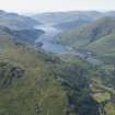
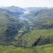
This, the only canal constructed in Breadalbane, was a quarter-mile (400m) branch from the River Falloch to a large basin near the coaching-inn [Inverarnan Hotel: NN31NW 14] at Inverarnan. The canal, which is still in existence, made it possible for Loch Lomond steamers to penetrate 2 miles (3.2 km) beyond the head of the loch. There were no locks.
J Lindsay 1958.
The 1st edition of the OS 6-inch map (Perthshire 1867, sheet ci) notes Canal [NAT] and indicates a near-straight length of canal running from N to S between the sinuous course of the Allt Arnan (to the W) and the straighter River Falloch (to the E). What has evidently been a basin is depicted at the N end of the canal and has apparently been fed by a lade or channel from the Allt Arnan. [The OS Name Book for Killin parish does not survive].
Information from RCAHMS (AKK, RJCM), 28 November 1997.

