
Strone, Loy Bridge


Road Bridge (Period Unassigned)
Site Name Strone, Loy Bridge
Classification Road Bridge (Period Unassigned)
Alternative Name(s) Loy River
Canmore ID 159937
Site Number NN18SW 14
NGR NN 14822 81838
Datum OSGB36 - NGR
Permalink http://canmore.org.uk/site/159937


- Council Highland
- Parish Kilmallie
- Former Region Highland
- Former District Lochaber
- Former County Inverness-shire
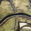
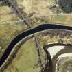
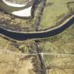
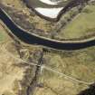
BANAVIE TO ACHNACARRY An excellent view of the Caledonian Canal as it runs parallel to the River Lochy is gained from the B8004, between Banavie and Gairlochy. Beyond the forestry plantations to its south, the West Highland Railway follows the route of the A82, where stretches of Wade's military road are still in evidence. These three feats of engineering transformed the landscape and significance of the Great Glen over two centuries, and revolutionised communications and travel in the Highlands. Notable along this stretch, and all engineered by Thomas Telford, mostly c.1815, are: Torcastle Aqueduct over Allt Sheangain, one of several aqueducts along this stretch (see also those at Mount Alexander and Strone), with three 24 0 ft-long parallel tunnels - two waterways and one narrow roadway - all beautifully finished inside with ashlar paving stones. Telford's hump-backed Bridge at Strone, 1803/4, carried the Parliamentary road over the River Loy. Bridge Keeper's Cottage, Moy, solitary beside the canal with windows in each gable to command views in both directions. It guards the only original surviving swing bridge, which is still hand operated using the old winch mechanism.
Taken from "Western Seaboard: An Illustrated Architectural Guide", by Mary Miers, 2008. Published by the Rutland Press http://www.rias.org.uk

NN18SW 14 14822 81838
Loy Bridge [NAT]
OS 1:10,000 map, 1975.
This bridge carries the B8004 public road over the River Loy just above the Loy Aqueduct (NN18SW 3.01) of the Caledonian Canal.
Information from RCAHMS (RJCM), 9 May 2006.

