
Strontoiller


Kerb Cairn (Later Prehistoric)
Site Name Strontoiller
Classification Kerb Cairn (Later Prehistoric)
Alternative Name(s) Strontoiller 1
Canmore ID 23205
Site Number NM92NW 7
NGR NM 90778 28950
Datum OSGB36 - NGR
Permalink http://canmore.org.uk/site/23205


- Council Argyll And Bute
- Parish Kilmore And Kilbride
- Former Region Strathclyde
- Former District Argyll And Bute
- Former County Argyll
NM92NW 7 90778 28950
(NM 9078 2896) Cairn (NR)
OS 1:10,000 map, (1975)
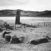
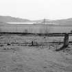
A cairn, and an associated standing stone (NM92NW 2), stand in pasture on the north side of the road through Glen Lonan. The cairn, which was excavated by the RCAHMS in 1967, is roughly circular, measuring 4.5 metres in overall diameter. It was originally kerbed by 15 large boulders of which 12 survive, measuring up to 1.3 metres in height on the south side, but apparently decreasing in size on the north side. White quartz chips had been deliberately placed round the bases of the kerbstones. The cairn material, earth, gravel and stones, was lower than the surrounding kerb, reaching a height of 0.75 metres only above natural ground level, and it is doubtful that it was ever of greater height.
On the old land surface there was a layer of burning and an unexplained hollow, and the base layer of the cairn material contained a very small quantity of cremated bone.
RCAHMS 1975, visited June 1967.
As described.
Surveyed at 1:2500 scale.
Visited by OS (D W R) 1 September 1971.
Field Visit (June 1967)
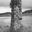
NM 907 289. Situated in pasture 450 m S of Strontoiller farmhouse on the flood -plain at the N end of Loch Nell, this cairn and its associated standing stone (Pl. 9A) are 185 m SSE of the stone circle No. 120. The cairn was excavated in 1967 and the following account is a summary of the published report (GAJ, ii (1971), 1-7).
Approximately circular on plan (Fig. 26), and measuring some 4' 5 m in overall diameter, it has been kerbed by fifteen large boulders, twelve of which survive. All but one of the kerb-stones are granite erratics, measuring up to 1'3 m in height on the S side and apparently decreasing in size on the N. Excavation revealed that white quartz chips had been deliberately placed round the bases of the kerb-stones. The cairn material, composed of earth, gravel and stones, was lower than the surrounding kerb, standing to a height of only 0'75 m above the natural ground-level, and it is unlikely that it was originally of greater height. On the old land-surface there was a layer of burning and an unexplained hollow (‘b’ on Fig. 26),while in the basal layer of cairn material a very small quantity of cremated bone was discovered. An intrusive pit (‘a’ on Fig. 26) was the result of an earlier excavation (PSAS, x (1872-4), 84-5). For further discussion of this class of cairn see RCAHMS 1975 p. 10.
RCAHMS 1975, visited June 1967.
Excavation (1967)
NM 907289. The stone setting to the E of the standing stone of Clach na Carraig was excavated by Mr J. N. G, Ritchie. It proved to be a kerbed cairn 15' in diameter, the stones of the kerb being graded in height from 4' 3" downwards. Twelve of the kerb stones survive and the stone holes of the other three were discovered. A central pit, 2' deep, contained some small fragments of cremated bone. The cairn material was only 2' 6" in height and consisted of earth and boulders. Publication will be in the Lorn volume of the Inventory of Argyll.
RCAHMS (DES 1967, 58)
Publication Account (1985)
The stone is one of the most impressive single monoliths in Argyll, standing to height of 4m and measuring 1.2m by 0.9m at the base. Tradition has it that the stone, Clach na Carraig or Clach Diarmid, and the little cairn to the south-east mark the burial place of the Irish hero Diarmid. The cairn, which is about 4.5m in overall diameter, has a kerb of large granite boulders; excavation in 1967 discovered only a small quantity of cremated bones and white quartz pebbles around the bases of all the kerb-stones. There are very few stone circles in Argyll, and that at Strontoiller is one of the more accessible, although the stones are not individually large. There are about thirty-one boulders set on a 'circle' of about 20m in diameter.
These three sites, together with a series of cairns at the southern end of Loch Nell, 3.5km to the south-west, suggest that this has been an important area of settlement in the neolithic and bronze ages.
Information from ‘Exploring Scotland’s Heritage: Argyll and the Western Isles’, (1985).

