
Pricing Change
New pricing for orders of material from this site will come into place shortly. Charges for supply of digital images, digitisation on demand, prints and licensing will be altered.
Kilvickeon Old Parish Church, Mull


Burial Ground (Medieval), Church (13th Century), Gravestone (16th Century), Gravestone(S) (18th Century), Sheela Na Gig (Medieval)
Site Name Kilvickeon Old Parish Church, Mull
Classification Burial Ground (Medieval), Church (13th Century), Gravestone (16th Century), Gravestone(S) (18th Century), Sheela Na Gig (Medieval)
Alternative Name(s) Scoor Churchyard; St Ewen's Chapel; Kilviceuen; Kilvickeon Burial Ground
Canmore ID 21972
Site Number NM41NW 1
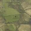
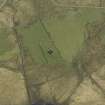
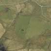
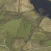
NGR NM 41198 19621
Datum OSGB36 - NGR
Permalink http://canmore.org.uk/site/21972


- Council Argyll And Bute
- Parish Kilfinichen And Kilvickeon
- Former Region Strathclyde
- Former District Argyll And Bute
- Former County Argyll
NM41NW 1 41198 19621
For present parish church (Bunessan kirk) at NM 3828 2181, see NM32SE 14.
(NM 4119 1961) Kilviceuen (NR)
Church (NR) (rems of)
OS 1:10000 map (1976)
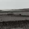
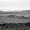
Old Parish Church, Kilvickeon: This ruined church stands within its burial-ground close to the E shore of Loch Assapol. It measures 13.1m from E to W by 5.7m transversely. The N and S walls are almost entire, but both end-walls are reduced to a height of about 1m. The masonry is of local slabs and boulders; there is some evidence to suggest that the external wall-faces were formerly harled. The original roofing, at least, was of thatch. The entrance-doorway, situated towards the W end of the N wall, was a tall arch-pointed opening. A little E of the doorway a fragment of carved sandstone projects from the outer face of the N wall at a height of 2.4m above ground level. This carving, now greatly worn, appears to have been of the type known as a sheela-na-gig. The E part of the interior seems to have been divided off from the remainder by a timber screen.
Almost nothing is known of the early history of this church, which was evidently one of the seven medieval parish-churches of Mull, but the existing fabric may probably be ascribed to the 13th century. When the church first comes on record in the early 15th century it is described as the church of St Eugenius in Ross, but it has been shown that the dedication was more probably to Ernan son of Eoghan, a nephew of St Columba.
The building appears to have continued in use for worship until the erection of a new church at Bunessan in 1804, but by 1795 the fabric had become ruinous.
Within the ruined church is a grave-slab with an inscription, beginning HIC IACET LMA/RIOTA FIL IA... It probably dates to between 1500 and 1560.
The RCAHMS also describe a number of 18th century table-tombs and headstones, to be seen in the churchyard.
Orig Paroch Scot (1854), New Statistical Account (NSA 1845) and object Name Book of the Ordnance Survey (ONB 1878) in describing the church and churcyard, describe the parish name as formerly Kilviceuen.
J Orr 1938; RCAHMS 1980, visited 1974.
As described.
Surveyed at 1:10,000.
Visited by OS (DWR) 4 June 1972.
Field Visit (23 June 1943)
This site was included within the RCAHMS Emergency Survey (1942-3), an unpublished rescue project. Site descriptions, organised by county, vary from short notes to lengthy and full descriptions and are available to view online with contemporary sketches and photographs. The original typescripts, manuscripts, notebooks and photographs can also be consulted in the RCAHMS Search Room.
Information from RCAHMS (GFG) 10 December 2014.
Conservation (1 September 2011 - 1 September 2013)
approached the Archaeology Scotland Adopt-a-Monument (AaM) team for support with vegetation clearance, recording and interpretation of this 13th-century chapel site. They were interested in conserving and maintaining the chapel, in finding ways to promote the site and provide improved access and interpretation information for local residents and visitors.
The group worked with AaM and Historic Scotland, 1 September 2011 – 1 September 2013, to determine the condition of the chapel, identify ways of consolidating the building, and remove vegetation from the graveyard.
Research was undertaken on the potential early origins of the chapel and burial ground, and different forms of on and offsite interpretation. The project also recorded the gravestone memorial inscriptions.
Archive and report: Archaeology Scotland and RCAHMS (intended)
Funder: Heritage Lottery Fund, Historic Scotland, Scottish Government, European Community Argyll and Islands Highland LEADER 2007–13
Rosie Burgess, Phil Richardson and Biddy Simpson - The Ross and Mull Historical Centre
(Source: DES)
Standing Building Recording (19 March 2013)
NM 41199 19622 Pre-conservation photographic and measured surveys were carried out of Kilvickeon Church, on 19 March 2013, to provide a baseline record of the monument’s present condition. This chapel is one of the seven medieval parish churches on Mull, and was probably dedicated to Ernan, son of Eoghan, a nephew of St Columba. It was in use until 1804, when a new church was built at Bunessan. The N and S walls are still standing to near roof height and the entrance to the church is intact. Above the doorway, the chapel still bears an intriguing, though worn, symbolic stone carving interpreted as a ‘sheela-na-gig’.
Archive: RoCAS and RCAHMS (intended). Report: OASIS and WoSAS
Funder: Addison Conservation + Design
Lynn Fraser and Mary Peteranna, Ross and Cromarty Archaeological Services, 2013
(Source: DES)
Watching Brief (10 March 2015 - 25 March 2015)
NM 41199 19622 A programme of monitoring was carried out, 10–25 March 2015, during conservation and consolidation work to Kilvickeon Church. The church is one of the seven medieval parish churches on Mull, probably dedicated to Ernan, son of Eoghan, a nephew of St Columba. During the course of the work the damaged E and W walls of the church were reconsolidated and made safe to visitors and a shallow trench was excavated across the church interior to allow for laying of a new gravel surface. The excavation work uncovered a rubble floor surface containing two worked mill stones and several stone slabs/ capstones. Three of the slabs were removed and relaid, revealing that inhumed burials lay below them, and there was evidence for two further graves below other slabs. One of these inhumations was in a well-cut grave, possibly stone lined. All of the burials were left in situ. The topsoil context also contained fragmented human bones.
Archive: Ross of Mull Historical Centre (intended)
Funder: Historic Scotland
Nicholas Johnstone and Mary Peteranna – AOC Archaeology Group
(Source: DES, Volume 16)

