
Iona, Iona Monastery, Vallum


Vallum (Early Medieval)
Site Name Iona, Iona Monastery, Vallum
Classification Vallum (Early Medieval)
Canmore ID 21651
Site Number NM22SE 4.02
NGR NM 286 244
Datum OSGB36 - NGR
Permalink http://canmore.org.uk/site/21651


- Council Argyll And Bute
- Parish Kilfinichen And Kilvickeon
- Former Region Strathclyde
- Former District Argyll And Bute
- Former County Argyll
NM22SE 4.02 centred 286 244
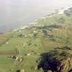
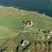
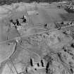
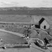
(Centred NM 286 245) The vallum of the Celtic monastery has enclosed an area of about 10 acres, roughly 1100' by 500', and seems to have been for delimitation rather than defence, the east side as defined by Thomas consisting of only a slight faced bank above an equally slight ditch. The rampart and ditch of the north side are still traceable from the NW corner as far as Thomas's NE corner. His east side was determined by sections, resistivity survey and ground observation except beneath the Abbey buildings where the course is deduced. South of the Abbey it was discovered at a depth of 6' running through the Relig Oran (NM22SE 10) to an original entrance roughly where the roadway now passes the Relig Oran wall.
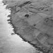
The west side, by far the best preserved, consists of a large, crudely constructed, earthen rampart with an external ditch and counterscarp bank. It is only intermittently traceable between the NW angle and the mill-stream (NM 2853 2460) but south of the stream it is clearly visible passing along the western brow of Cnoc nam Carnan (NM 2853 2455). On Cnoc nan Carnan there is a gap which Crawford thought was an original entrance, with on the south side, apparently in the bank itself the remains of a round enclosure which he interpreted as a hut circle.
North of the entrance the top of the rampart is 7' or 8' above the bottom of the ditch, and SE of it the rampart becomes double, one portion about 6' high, curving round the hill at once, and the other continuing a little south before turning east, both alike ending on the precipitous east brow of the hill.
From the north side of the entrance there runs an apparently artificial scarp which ends on the steep northern brow of the hill. A rocky fort is thus formed, in which there are suggestions of dwelling places in the form of smooth, turf-grown hollows, although similar natural hollows do occur. Crawford identifies this with Martin's "Dun ni Manach" . Crawford's ground interpretation of the site in 1933 continued the north side of the vallum past Thomas's NE angle, to meet a small inland cliff 220 yds NE of the Abbey - an interpretation which is apparently supported by aerial photographs.
Although he could see no trace of it, Crawford also suggested that the S side might continue from its last known point above the road to meet this small cliff, which itself might form the east side of the enclosure. Other crop-marks show up within the enclosure, notably a right-angled ditch running from about NM 2857 2465 to NM 2867 2664. Visible on OS AP's (OS.71.415: 1092, 1096, flown 1971).
O G S Crawford 1933; A C Thomas 1957; A C Thomas 1959; A C Thomas 1971; RCAHMS 1972; A D S MacDonald and L R Laing 1973.
The W side of the Vallum is generally as described by Crawford but no trace of the E side survives. The N is still traceable as a very slight spread bank with an outer ditch, between NM 2865 2471 and NM 2880 2463, where it ends on a slight slope. The ditch and bank which turn SE from NM 2849 2452 to terminate on the top of a rock face above the road appears to be alien to the other sections and it is more probable that the Vallum continued to the S of the possible entrance, where it is visible as a slight ditch with traces of scarping on the slope immediately to the E, to end at NM 2847 2442. There is no trace on the S. There is nothing to suggest that the sub-circular feature at NM 2850 2453 is a hut circle and there is no evidence of a fort just N of the (?) entrance on Dun ni Manach, otherwise named Cnoc nan Carnan. No evidence of any further remains could be identified.
Surveyed at 1:2500.
Visited by OS (RD) 15 June 1972.
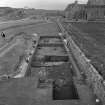
Excavation by Barber in 1979 revealed a possibly Columban Vallum Ditch (Ditch 2 on plan) and an early 7thc successor (Ditch 1).
J W Barber 1981.
Site assessment report was intended as preliminary to future building and drainage work. However, much of this work was found to have already proceeded; some assessment was therefore made of damage caused.
NM 2850 2457 (centre). Road to MacLeod Centre across line of W vallum resurfaced, levelled and straightened. Ground to either side apparently 'landscaped' and part of outer vallum bank now 'lost'.
Electricity cable laid from transformer at NM 2853 2456 to MacLeod Centre at NM 2847 2457, cutting across vallum. Trench visible at NM 2851 2457 but disappears to W under spoil from roadworking. Trench 0.50m wide and reportedly 0.60m deep. Drainage channel cut at NM 2847 2456, just outside of scheduled area. This will alter the nature of the drainage in the area of the vallum to the E.
Trench, reportedly 6m by 3m and 3.50m deep, machine-cut for installation of septic tank at NM 2860 2462. Area, 10-12.50m diameter, is covered in spoil and a large amount of burnt stone is apparent on surface.
Test-pit dug 5m to E of easternmost drain cover. Distinct burnt deposit, containing daub, encountered at depth of 0.60m.
Area outside Iona Pottery at NM 2859 2459 and to N of abbey at NM
2868 2456 trenched for insertion of new drains. Damage likely to be similar to above.
Test-pits also excavated in areas where development had not yet gone ahead (the original brief). Clear that proposed work at NM 2857 2458 (excavation for shed behind cafe), NM 2877 2452 (drains) and NM 2866 2455 will disturb underlying archaeological stratigraphy. Further excavation is proposed.
C E Lowe and I D Mate 1988; C E Lowe 1988.
In 1989, a section was cut through the vallum bank immediately N of an earlier trench excavated by Thomas. It indicated that the bank was built on a layer of peat and samples of the uppermost layer of peat should produce radiocarbon dates for this segment of the monastic enclosure.
F McCormick 1989.
Aerial Photography (April 1969)
Oblique aerial photographs of sites and monuments on Iona, Argyll, photographed by John Dewar in 1969.
Geophysical Survey (January 1973)
A geophysical survey was undertaken over part of the monastic vallum in January 1973.
N. Balaam, 1981, 5
Trial Trench (1973)
A section was excavated across the strong linear anomaly running west from the shore towards the St Columba's hotel. The section revealed that the anomaly was caused by a ditch, over 2m deep and nearly 3m wide.
N. Balaam 1981, 5
Excavation (1979)
Excavation by Barber in 1979 revealed a possibly Columban Vallum Ditch (Ditch 2 on plan) and an early 7thc successor (Ditch 1).
J W Barber 1981.
Field Visit (September 1980)
THE VALLUM.
The surviving evidence for the boundaries of the early monastery (NM22SE 4) varies in nature, as has been indicated above. Impressive remains of a ditch with inner and outer ramparts are visible on the w side of Cnoc nan Carnan, and on the upper terrace above the inland cliff S of Clachanach, but its continuation E of the road, on the NE side of the enclosure, has been almost entirely obliterated by ploughing. It is, however, visible on air photographs, which also show, some 50m to the s, the NW angle and part of the N side of an inner ditched enclosure (C on Fig.), presumably of a different period. Intensive cultivation has destroyed all surface indications in the field s of the Abbey, and aerial photography in that area has as yet been unrewarding, but geophysical survey in 1973 and 1977, confirmed at two points by excavation, suggested the existence of a complex series of overlapping ditches, again presumably of more than one period.
The NE limb of the vallum extends to the scarp at the head of the rough ground falling towards the foreshore, but no artificial boundary has been identified beyond this scarp, and the E limit of the enclosed area is therefore uncertain. If, however, it is assumed that the boundary was formed by the scarp itself, the maximum dimensions of the enclosure may have been about 360m from NNE to ssw by about 200m at the N and nearly 300m at the s end, and its area may have exceeded 8 ha (20 acres). The portions of both the inner and outer enclosure identifiable N of Sruth a' Mhuilinn are rectilinear, but have rounded NW angles. To the sw of the Abbey, however, it is possible that in each period a rectilinear main enclosure had attached to it an annexe within a curving ditch (cf. infra).
The vallum monasterii ('rampart of the monastery') at Iona is mentioned by Adomnan in his account of an incident during Columba's lifetime, and it is known from other sources that such a boundary was normally constructed at the foundation of an Irish monastery. Only one of the three sections taken across the boundary at Iona has produced any dating evidence, however, and in the absence of extensive excavation in the area E of Reilig Odhrain, the relative priority of the inner and outer enclosures must remain uncertain.
See RCAHMS 1982 pp. 36-39
RCAHMS 1982, visited September 1980
Field Visit (April 1996 - May 1996)
The vallum encloses an area of circa 10 acres. It is visible as an upstanding monument to the west of the public road which runs northwards to the west of the abbey. This upstanding west side appears as a large, earthen rampart with external ditch and counterscarp bank. It is traceable from the north-west corner to the mill stream and is clearly visible passing along the western brow of Cnoc nam Carnan. The north and south sides of the vallum are visible as cropmarks while the east is presumed to follow the edge of the raised beach to the immediate east of the abbey.
(ION96 022)
Information from NTS (SCS) January 2016
External Reference (28 October 2011)
Scheduled as element within 'The monument known as St Mary's Abbey, Iona, monastic settlement [comprising] the remains of the large early historic monastic settlement founded by St Columba in AD 563, St Martin's Cross, and parts of medieval buildings associated with the Benedictine Abbey of St Mary founded around AD 1200.'
Information from Historic Scotland, scheduling document dated 28 October 2011.

