
Tiree, Dun Ibrig


Dun (Period Unassigned)
Site Name Tiree, Dun Ibrig
Classification Dun (Period Unassigned)
Canmore ID 21533
Site Number NM04SW 1
NGR NM 0259 4440
Datum OSGB36 - NGR
Permalink http://canmore.org.uk/site/21533


- Council Argyll And Bute
- Parish Tiree
- Former Region Strathclyde
- Former District Argyll And Bute
- Former County Argyll
NM04SW 1 0259 4440.
(NM 0259 4440) Dun Ibrig (NR)
OS 1:10,000 map, (1976)
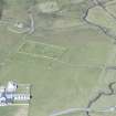
Dun, Dun Ibrig: Situated on a low flat-topped knoll in rough pasture, about 600 m N of Baugh township, there are the severely denuded remains of a galleried dun and its outwork, overlain by a complex of secondary structures. Except on the NE, where it is linked by a low grassy ridge to an area of higher, rocky terrain, the knoll rises about 2m above the general level of the surrounding ground. However, the extensive marsh by which it is said to have been formerly surrounded (E Beveridge 1903) must once have afforded it a considerable degree of natural protection. The dun is oval on plan and measures 20.4m by about 16m over the ruins of a dry-stone wall, which survives for the most part as a low spread of grass-grown stony rubble. No inner facing-stones can now be seen, but several stretches of the outer face have survived in position, the best- preserved portion being on the SE, where it stands 0.65m high in two courses. The entrance, situated on the ESE, is the only point at which it is still possible to ascertain the original wall-thickness; the positions of the surviving outer and inner corner-stones of the N and S passage-walls respectively indicate that in this sector it was approximately 3.5m. Within the body of the wall on the NNE there is a short length of an intramural gallery, about 0.6m wide, and immediately to the N of the entrance a marked depression in the wall core suggests that there may also have been a small guard-chamber.
Much of the interior is choked by fallen rubble, but in the E half the debris has been revetted by a regular stone facing to form a roughly oval enclosure, measuring about 7.6m by 5.5m internally, which has re-used the entrance of the dun. Although it is clearly a secondary work, the date and purpose of this enclosure are uncertain, and the matter is complicated by the fact that a relatively recent, and now very ruinous, stock enclosure has been constructed on the remains, partially obscuring the revetment. It is conceivable, however, that the enclosure represents a reconstruction of the interior of the dun in the later prehistoric period, as at Dun Mor, Vaul (NM04NW 3).
The dun has been additionally protected by a stone wall drawn round the foot of the knoll on all sides. It survives for the most part as a grass-covered stony scarp, 1m in average height, from which occasional large outer-facing-stones or stretches of the outer face project.
The entrance was probably situated on the NE, facing the line of approach from higher ground, but the wide gap that exists here at present is doubtless the result of recent disturbance. The other wide gap, on the NW, and much of the space between the dun and the outer wall are occupied by the remains of slight rubble-built enclosures of relatively modern date.
RCAHMS 1980, visited 1903; E Beveridge 1903; E W MacKie 1963.
The remains of an oval galleried dun, as described.
Resurveyed at 1:2500.
Visited by OS (D W R) 29 June 1972.
Publication Account (2007)
NM04 2 DUN IBRIG
NM/026444
This possible ground-galleried broch or ‘galleried dun’ on Tiree stands on a low, flat-topped mound in low ground, now rough pasture-land; although markedly oval in shape it contains traces of a presumably ground-level intramural gallery (visited 8/62). The Commission classed it as a dun [3] but there is no reason to deny the site the status of a badly ruined broch; oval and sub-circular brochs are known in a much better state of preservation (e.g. Dun Torcuill, NF87 4). The surrounding ground is supposed to have been a marsh not long ago [2] (“Turnbull’s map of Tiree 1768-9 (Cregeen, Estate Instructions and map) shows areas of standing water to the west and south-east.” (RCAHMS 1980, 110, f.n. 2.)) so the site may not always have been as defenceless as it looks now; it might have been built on an islet in a shallow loch.
The building measures about 20.4m by 16m overall and some of the facing stones of the outer face can be seen, though no inner ones except at the entrance on the east-south-east. Here the wall is about 3.5m thick. A short length of intramural gallery can be traced on the north side and the presence of a depression to the right of the entrance suggests that there is a guard chamber here. There is a secondary oval enclosure on top of the rubble in the interior, though its age is uncertain [3]. An outer stone wall runs round the site at the foot of the knoll.
Sources: 1. NMRS site no. NM 04 SW 1: 2. Beveridge 1903, 112-14: 3. RCAHMS 1980, 110-11, no. 210 and fig. 128.
E W MacKie 2007

