
Vatersay, Dun A' Chaolais


Broch (Iron Age)(Possible), Building(S) (Period Unassigned), Shieling Hut(S) (Post Medieval)
Site Name Vatersay, Dun A' Chaolais
Classification Broch (Iron Age)(Possible), Building(S) (Period Unassigned), Shieling Hut(S) (Post Medieval)
Alternative Name(s) Bhatarsaigh
Canmore ID 21395
Site Number NL69NW 3
NGR NL 6285 9707
Datum OSGB36 - NGR
Permalink http://canmore.org.uk/site/21395


- Council Western Isles
- Parish Barra
- Former Region Western Isles Islands Area
- Former District Western Isles
- Former County Inverness-shire
NL69NW 3 6285 9707.
(NL 62859707) Dun A'Chaolais (NR).
OS 6"map, Inverness-shire, 2nd ed., (1904)
Dun a' Chaolais, a broch, built on a rocky knoll. Its outer face, almost entirely broken down, is still 3' high to S.W. Inside better preserved, and on N.W. 10' high with traces of scarcement. Internal diameter about 29'6". Probable entrance slightly S. of E., and, within walls,cells at both sides of this. Ground level gallery in W. half of building, where traces of upper gallery also survive. To the west of the broch an outer courtyard is enclosed by a stone wall (max. height 3', and some 30' from the main building) which curves round to meet the wall of the broch on the north. There are numerous stone foundations outside the dun (sic), several of them evidently of late date.
RCAHMS 1928.
The remains of the broch are generally as described by RCAHMS. It has an external diameter of about 16.0m and an internal diameter of about 8.0m. The outer and inner wall faces are visible round most of the circumference, having a max. height of 1.1m, and 0.9m respectively. The entrance in the NE is about 1.5m wide with traces of a small chamber on either side. A gallery about 1.0m wide is traceable round most of the broch wall. Attached to the NW side of the broch is a small courtyard enclosed by a slight turf-covered stone wall 0.3m high. Masses of fallen stones lie within the broch and around its base.
Immediately to the south and SE are the footings of at least two buildings and four shielings evidently of a later date. The larger building is sub-oval and is formed by a turf-covered stone wall 1.5m wide and 0.6m high. The outlines of a similar building of this group lie in the attached courtyard.
Surveyed at 1:2500.
Visited by OS (W D J) 22 May 1965.
Field Visit (12 June 1915)
Dun a' Chaolais, Vatersay.
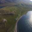
To the west of Ben Orosay, on the north of Vatersay, some 400 yards south of the Sound of Vatersay, at an elevation of 100 feet above sea level, is a broch, Dun a' Chaolais, built on a rocky knoll rising sharply about 20 feet above its surroundings, except towards the south-east where it falls away gradually in a series of rocky steps. The broch is in a ruinous condition, the interior being full of fallen stones. While the outer face is almost entirely broken down, its best preserved part, on the south-west, still maintains a height of 3 feet ; on the inside, owing to the protection afforded by the dislodged stones, it is in better condition, and on the north-west a height of probably about 10 feet remains. The broch is circular, measuring about 29 feet 6 inches in diameter internally, and the wall varies from 10 feet 3 inches to nearly 12 feet in thickness. Part of a scarcement 8 inches wide is seen on the inside of the south-western arc of the wall, but its height is not determinable. The entrance has probably been slightly to the south of east. Within the thickness of the wall to the north of the supposed entrance there is a small circular cell 4 feet in diameter above the debris which it contains, and to the south of the entrance the inner curve of an oval cell, 7 feet in length, is traceable. Portions of a gallery on the ground level within the wall are seen round the greater part of the western half of the building, many lintel stones remaining in position. The gallery is about 3 feet wide, and the inner wall varies from 3 feet 3 inches to 4 feet 2 inches in thickness, and the outer wall from 3 feet to 4 feet 6 inches. This chamber is full of debris. The inner face of the inner wall of an upper gallery, standing 2 feet in height above the lintels of the lower gallery, survives at several places on the west.
To the west of the broch there has been an outer courtyard enclosed by a stone wall, its outer face built at a distance of 30 feet 10 inches from the main building. This wall, which shows a height of 3 feet in one place, is built on the edge of the rock, and curves round to meet the wall of the broch on the north.
There are numerous stone foundations outside the dun, several of them evidently of late date.
RCAHMS 1928, visited 12 June 1915.
OS map: Barra lxiv.
Publication Account (2007)
NL69 3 DUN a' CHAOLAIS
NL/629971
This probable ground-galleried broch stands about 6m (20 ft) above the surrounding ground on a low rocky knoll. The knoll has steep sides except on the south-east where it falls away gradually in a series of rocky steps. The broch is ruinous, the best preserved part of the outer wallface being only 92cm (3 ft) high (on the south-west). The site is an interesting one in that, despite its dilapidated and unexcavated condition, and despite the fact that it is on an island group where undoubted brochs are very scarce, there is no doubt that the building is one. The masonry has that massive, solid feel which is characteristic of solid-walled broch towers (visited in 1980 and on 27/6/88). In 1980 the site was shrouded in mist when the author arrived; nevertheless the ruins immediately ‘felt’ like those of a broch, strange though that may sound. Presumably the memories of so many such sites allowed some subconscious connections to be made. If the author was addicted to Celtic romanticism he would admit that he seemed to hear the horns of the broch chieftain faintly blowing.
A ground-level mural gallery about 92cm (3 ft) wide, with many lintel stones still in position, is traceable round most of the west half of the broch and parts of the inner wall of an upper gallery are also to be seen on the west. The inner wallface, protected by debris, is better preserved and stands to perhaps 3.05m (10 ft) on the north-west; it can be seen for a short distance below the level of the lintels roofing the mural gallery. Part of a scarcement 20cm (8 in) wide was seen on the inner wallface on the south-west in 1980 but was not observed in 1988; on the other hand the lintel of a door into the wall on the north side (at about 2 o’clock) could well be an extension of the scarcement across the doorway. There is another doorway into the wall, without a lintel, at about 12 o’clock. One of these doorways should be that leading to the mural stair, which is probably in the north or north-north-east.
The entrance passage was thought to be on the east [2] but the only sign of it now is a radial depression in the wall. Traces of an intra-mural cell are visible on the right of this and are probably a guard cell; its rounded inner end is visible and it is about 1.2m (4 ft) in diameter, but obviously this is some distance above the floor. An oval cell about 2.1m (7 ft) long was visible on the left side of the passage but there are no signs of this now. Both cells are full of debris.
An outer wall runs round on the west side, reaching a maximum distance of 9.8m (32 ft) from the broch, and curves in to join the wall of the latter on the north.
Dimensions: internal diameter 9.0m (29.5 ft), wall thickness 3.13m (10 ft 3 in) to 3.67m (12 ft); the external diameter must therefore be about 15.9m (52 ft) and the wall proportion about 42.5%. In 1988 a fresh survey of the inner face was carried out and the broch interior proved to be almost an exact circle, with a radius of 4.39 +/- 0.11m. The diameter is therefore 8.78m (28.8ft).
Sources: 1. NMRS site no. NL 69 NW 3: 2. RCAHMS 1928, 129-30, no. 447.
E W MacKie 2007

