
Peterhead Airfield


Firing Range (Second World War)
Site Name Peterhead Airfield
Classification Firing Range (Second World War)
Alternative Name(s) Eastfield
Canmore ID 134493
Site Number NK04NE 22
NGR NK 08431 47177
NGR Description Centred NK 0830 4707
Datum OSGB36 - NGR
Permalink http://canmore.org.uk/site/134493


- Council Aberdeenshire
- Parish Peterhead
- Former Region Grampian
- Former District Banff And Buchan
- Former County Aberdeenshire
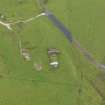
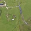
NK04NE 22 centred 0830 4707
For Peterhead Airfield and buildings see NK04NE 12.00
An archaeological desk-based assessment and rapid field survey was undertaken in March 1997 on the proposed route of a pipeline running from St Fergus Offtake Station to the proposed pressure reducing station at Peterhead Power Station. Five sites situated within the corridor examined were listed in the NMRS. The following are amongst the sites identified in the assessment:
NK 082 469 Structures (miniature rifle range).
NK 083 470 Structures (miniature rifle range).
NK 084 472 Structures (miniature rifle range).
Several other enclosures, wells, tracks, field boundaries and dykes were also recorded. Fuller report in the NMRS.
Sponsor: Penspen Ltd.
R Strachan 1997.
Many of the above structures refer to the remaining upstanding buildings within the airfield technical area.
The miniature rifle range is at NK 0830 4707.
Inforation from RCAHMS (DE), November 2004

