
Peterhead Airfield, Technical Site


Military Camp (Second World War)
Site Name Peterhead Airfield, Technical Site
Classification Military Camp (Second World War)
Alternative Name(s) Longside Airfield
Canmore ID 267769
Site Number NK04NE 12.07
NGR NK 0822 4690
NGR Description Centred NK 0822 4690
Datum OSGB36 - NGR
Permalink http://canmore.org.uk/site/267769


- Council Aberdeenshire
- Parish Peterhead
- Former Region Grampian
- Former District Banff And Buchan
- Former County Aberdeenshire
NK04NE 12.07 centred 0822 4690
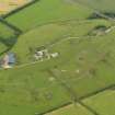
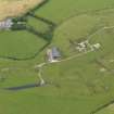
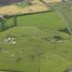
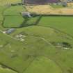
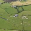
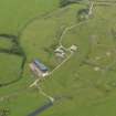
The technical area for Peterhead Airfield is situated at the SE perimeter of the runways and N of the A950 road. The control tower, aircraft hangars (Blister and a possible type 'T'), repair sheds, huts, Nissen huts and emergency air-raid shelters are all visible on RAF vertical air photographs (106G/Scot/UK109, 3013-3014, flown 23 May 1946).
Apart from two remaining roofed buildings, most of those seen on the photographs have now been either demolished or survive in an unroofed condition along with the emergency air-raid shelters and the concrete bases for huts. The control tower had been demolished by 1969, as it is visible as a pile of rubble on vertical air photographs of that date (OS 69 176, 060, flown 6 June 1969).
Information from RCAHMS (DE), November 2004
Note (2 February 2021)
The Pillbox Study Group have recorded two Blast Air Raid shelters, depicted on an OS 1:2500 map (1972) at NK 0811 4666 and NK 0816 4691.
Information from Pillbox Study Group to HES 2 February 2021

