
Scheduled Maintenance
Please be advised that this website will undergo scheduled maintenance on the following dates: •
Tuesday 3rd December 11:00-15:00
During these times, some services may be temporarily unavailable. We apologise for any inconvenience this may cause.
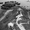
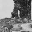
Old Slains Castle


Tower House (Medieval)
Site Name Old Slains Castle
Classification Tower House (Medieval)
Alternative Name(s) Slains Castle
Canmore ID 20953
Site Number NK03SE 2
NGR NK 05328 30004
Datum OSGB36 - NGR
Permalink http://canmore.org.uk/site/20953


- Council Aberdeenshire
- Parish Slains
- Former Region Grampian
- Former District Gordon
- Former County Aberdeenshire
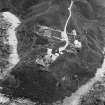
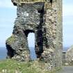
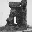
Old Slains Castle, 15th century. 'Crowning a steep peninsulated rock' (Groome), represented by stark fragment, c.8ft thick, of south-east angle of a vaulted tower of the Hays, which was blown up on the orders of James VI in 1594 in return for eighth Earl's support for the Earl of Huntly's rebellion that year.
Taken from "Aberdeenshire: Donside and Strathbogie - An Illustrated Architectural Guide", by Ian Shepherd, 2006. Published by the Rutland Press http://www.rias.org.uk

NK03SE 2 05328 30004
(NK 0533 3000) Slains Castle (NR)
OS 6" map, (1959)
Not to be confused with Slains Castle (NK 1015 3610), for which see NK13NW 1.
For nearby cannon, see NK03SE 19.
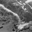
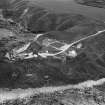
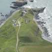
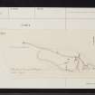
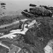
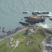
Slains Castle stands on a rocky peninsula and appears to be the earliest example of the new type of tower house erected in the 14th century. It was demolished in 1594 and only the SE corner remains.
There were two lines of defence. The inner spanned the narrowest part of the peninsula and consisted of a ditch, still well preserved, behind which was the barmkin wall and gateway. Of these little or nothing remains. The outer ward, on the slopes of the mainland, enclosed a well and was defended by earthen ramparts which may be older than the stone castle.
W D Simpson 1940; D MacGibbon and T Ross 1887-92.
The remains of Slains Castle, a tower house, are as described by Simpson. Traces of the barmkin wall can be seen in the face of the cliff to the S and SE of the tower house, but nothing remains of the gateway and wall. The ditch, which is partly natural, has been mutilated by late constructions. The "outer ward" is surrounded by steep natural slopes surmounted by a rampart of earth and some stones, about 3.0m wide and 1.0m maximum height, which survives only on the W and S. Late building has almost certainly destroyed it elsewhere. There is no trace of a well.
Resurveyed at 1:2500.
Visited by OS (NKB) 4 September 1970.
Visible on air photograph AAS/93/14/G30/28. Copy held by Grampian Regional Council.
Information from M Greig, Grampian Regional Council, March 1994.
Air photographs: AAS/94/18/G38/10-15.
NMRS, MS/712/21.
Old Slains Castle, 15th century. 'Crowining a steep peninsulated rock' (Groome). Represented by a stark fragment,
c. 8ft thick, of the SE angle of a vaulted tower of the Hays, which was blown up on the orders of James VI in 1594 in return for the eigthth Earl's support for the Earl of Huntly's rebellion that year.
I A G Shepherd 1994.
Scheduled as 'Slains Castle... the remains of a tower-house, of later medieval date, surviving as the south-eastern corner of the structure, with a series of earthworks defending a steep-sided, rocky coastal promontory that projects into the North Sea.'
Information from Historic Scotland, scheduling document dated 6 November 2008.

