
Mill Of Fintray


Enclosure (Period Unassigned), Pit(S) (Period Unassigned), Pit Defined Cursus (Neolithic), Ring Ditch (Period Unassigned)
Site Name Mill Of Fintray
Classification Enclosure (Period Unassigned), Pit(S) (Period Unassigned), Pit Defined Cursus (Neolithic), Ring Ditch (Period Unassigned)
Alternative Name(s) Hatton Of Fintray; Hatton Bridge; Boat Of Hatton; Jasmine Cottage
Canmore ID 83494
Site Number NJ81NW 54
NGR NJ 83570 16330
NGR Description Centred NJ 83570 16330
Datum OSGB36 - NGR
Permalink http://canmore.org.uk/site/83494


- Council Aberdeenshire
- Parish Fintray
- Former Region Grampian
- Former District Gordon
- Former County Aberdeenshire
NJ81NW 54 centred 83570 16330
For possibly-associated ring-ditch or enclosure (NJ 83740 16210), see NJ81NW 50.
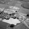
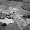
Cropmark of a large rectangular enclosure of at least four adjoining compartments, aligned NW-SE. The easternmost compartment is palisaded, a pit alignment is visible on the whole of the perimeter, and the rest is defined by a thin linear trace.
Information from Mrs M Greig (Grampian Regional Council), 24 April 1995.
The monument comprises the remains of a long rectangular enclosure defined by pits and ditches, visible as a cropmark on oblique aerial photographs. The enclosure is at least 150m long and c. 20m wide. There are at least three transverse lines of pits, cutting the enclosure into four rectangular segments. The easternmost segment is defined wholly by pits; the other segments have a continuous ditch on their long sides.
Information from Historic Scotland, scheduling document dated 23 December 1996.
These cropmarks are situated on the edge of a terrace and comprise: large rectilinear enclosure; a possible cursus comprising at least four adjoining compartments aligned NW-SE (the easternmost compartment is palisaded and the pit-alignment of its wide perimeter is visible, with a thin linear trace being visible elsewhere); further pit-alignments to the S of the enclosure (the W end being 'flared'); a possible enclosure (visible as a possible enclosure in the W field). List of air photographic cover.
NMRS, MS/712/19.
Location cited as NJ 836 163 and classified as palisaded enclosure/ring ditch; air photographic cover listed.
NMRS, MS/712/21.
Classified as 'ring ditches/site of cursus (cropmark)'. 1997 air photographic cover listed.
NMRS, MS/712/29.
Scheduled as 'Jasmine Cottage, cursus monument and barrows 160m SE of... visible as cropmarks on oblique aerial photographs.'
Information from Historic Scotland, scheduling document dated 20 February 2009.

