
Fullerton


Stone Circle (Neolithic) - (Bronze Age), Unidentified Pottery (Bronze Age)
Site Name Fullerton
Classification Stone Circle (Neolithic) - (Bronze Age), Unidentified Pottery (Bronze Age)
Alternative Name(s) Cairnhall; Fulerton
Canmore ID 18569
Site Number NJ71NE 14
NGR NJ 7839 1797
Datum OSGB36 - NGR
Permalink http://canmore.org.uk/site/18569


- Council Aberdeenshire
- Parish Kintore
- Former Region Grampian
- Former District Gordon
- Former County Aberdeenshire
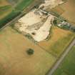
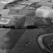
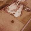
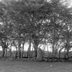
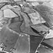
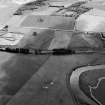
A single erect stone is all that remains of this stone circle situated on the S side of a small copse of trees 400m SE of Fullerton farmstead. The stone is a granite block measuring 0.9m in breadth by 0.8m in thickness and 1.95m in height, and has been incorporated into a circular bank that encloses a small plantation. The interior of the enclosure, which measures 16.3m in internal diameter, is now choked with field-cleared stones. Earlier accounts suggest that the circle was about twenty-eight feet (8.5m) in diameter, and had comprised six or seven stones, although only three stones survived at that time, and of these two were prostrate and broken (Anderson 1886, 108). Investigations by Dalrymple during the mid 1850s revealed an area of burning nine feet (2.7m) in diameter just below the surface at the centre of the circle, and a grave, aligned east and west, was found in the middle; this contained an unburnt skeleton, together with fragments of an urn and cremated bones. Around the grave, seven deposits of burnt bones were also discovered, some of which were contained in small circular cists and some of which included fragments of urns. The context for these deposits is uncertain, but suggests secondary activity within the circle, and a radiocarbon date obtained from cremated bone provides a Late Bronze Age date, consistent with the reclassification of the associated pottery as Late Bronze Age flat-rimmed ware (Kilbride-Jones 1935, 446-7; DES 2003, 169).
Information from RCAHMS (ARG) 31 October 2006
NJ71NE 14 7839 1797.
For stone circles at Broomend of Crichie (NJ 7792 1967), Cairnhall (NJ 7850 1759), Hill of Tuack (NJ 7957 1544) and Castle Hill, Kintore (NJ 7939 1634), see NJ71NE 6, NJ71NE 17, NJ71NE 27, NJ71NE 32.00 respectively.
(NJ 783 91797) Stone Circle (NR) (Remains of)
OS 6" map, (1938)
The stone circle consists of a low central mound, a vaguely-defined ditch, and an equally vague enclosing ridge, upon which, on the SW, stands a single stone, about 6 feet (1.8m) high. Originally there must have been 7 stones.
An oriented grave 5 feet (1.52m) long by 2 feet (0.6m) wide by 2 feet 3 inches (0.69m) deep, containing an unburnt skeleton and a cremated burial with Bronze Age urn fragments, was found at the centre of a fire-marked area 9 feet (2.74m) in diameter, just below the surface at the centre of the stone circle. Seven deposits of burnt bones, some in small circular cists, were found around this central burial. Fragments of Bronze Age urns were found with some of the burials.
Some of the urn fragments and bones are in the National Museum of Antiquities of Scotland (NMAS).
F R Coles 1901.
The circle had been about 28 feet (8.5m) in diameter, and probably consisted of six or seven stones.
J Anderson 1886.
The thirteen sherds in the National Museum of Antiquities of Scotland (NMAS) are from thirteen Early Iron Age vessels, showing that, although erected in the Bronze Age (on analogies with the Broomend of Crichie circle - NJ71NE 6) it continued in use into the Iron Age.
H E Kilbride-Jones 1935.
A similar site excavated by Canon Greenwell at Ford in Northumberland was found to be a barrow containing a circle of stones, and Bronze Age burials.
W D Simpson 1957.
This feature now planted with trees is as described by Anderson (1886) and resembles a saucer barrow in appearance. A low stone wall revetment of the outer edge of the circle is probably comparatively modern.
Surveyed at 1/2500.
Visited by OS (RD) 18 March 1964.
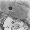
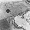
Air photographs: CUCAP AKD 18-19, flown 23 July 1964.
NMRS, MS/712/67.
All that remains of this stone circle is a single erect stone on the S side of a small copse of trees about 400m SE of Fullerton farmsteading (NJ71NE 228). The granite block, which measures 0.9m in breadth by 0.8m in thickness at ground-level and 1.95m in height, has been incorporated into a circular plantation bank 2.5m in thickness and 0.3m in height. The interior of the plantation enclosure, which measures 16.3m in internal diameter, is choked with field-cleared stones.
The accession number of the pottery found here and donated to the then National Museum of Antiquities in 1856 is RMS: EP 22.
Visited by RCAHMS (JRS, ATW), 22 November 1996.
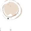
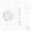
Measured Survey (15 September 1999)
RCAHMS surveyed Fullerton stone circle on 15 September 1999 with plane table and alidade producing a plan and section at a scale of 1:100. The survey drawing was later used as the basis for an illustration redrawn in vector graphics software at a scale of 1:250.
Field Visit (8 February 2017)
The plan taken in 1999 was modified to show in greater detail what remains of the stone-revetted, earth-embanked roundel incorporating the surviving orthostat. No trace of an internal cairn or a stony platform of the kind depicted in Coles' profile was observed beneath the field clearance and it is possible that the internal ditch which he shows represents no more than the difference in height between this and the inner scarp of the surrounding wall.
Visited by HES, Survey and Recording (ATW and AMcC), 8 February 2017.

