
Coupar Angus - Braemar - Corgarff - Fort George


Military Road (18th Century)
Site Name Coupar Angus - Braemar - Corgarff - Fort George
Classification Military Road (18th Century)
Canmore ID 73373
Site Number NJ20NE 8
NGR NJ 2725 0734
NGR Description NJ 2990 0582 to NJ 2545 0999
Datum OSGB36 - NGR
Permalink http://canmore.org.uk/site/73373


- Council Aberdeenshire
- Parish Strathdon
- Former Region Grampian
- Former District Gordon
- Former County Aberdeenshire
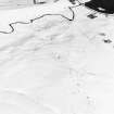
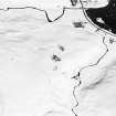
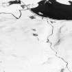
Two military roads meet at Corgarff. One of the roads led east, towards Aberdeen, and the other north, towards Fort George. In some places the road survives as a grass track, 4m in width, but elsewhere a modern road has been constructed over much of the military route.
During the eighteenth century, hundreds of miles of military roads were constructed in highland Scotland, improving communications and transport, and thus helping the government control the area. The routes linked places of military importance, like Corgarff, and were built using techniques pioneered by the Romans, layering gravel on top of small stones and boulders. This section of road was begun in 1753.
Major-General George Wade, Commander-in-Chief of Scotland, was responsible for initiating the road system. He later appointed Major William Caulfeild, who oversaw the construction of a further 748 miles of road.
Text prepared by RCAHMS as part of the Accessing Scotland's Past project
NJ20NE 8 2725 0734. MR 9.
Formerly LIN 511.
For associated bridges, see NJ20NE 9, NJ20NE 10, NJ20NE 11.
NJ 2990 0582 - 2962 0637 Modern road (A939) on line.
NJ 2962 0617 - 2616 0863 This stretch of military road is well preserved as a grass track some 4m wide. The road comes down to the W bank of the River Don, passing the Youth Hostel at Delachuper (NJ 2687 0780), before rejoining the A939 about half a mile from Corgarff Barracks (NJ20NE 1). There are what appears to be later deviations from the line of the military road at NJ 2917 0654 - 2934 0652 and at NJ 2839 0682 - 2848 0678. There are also three bridges on the stretch (see NJ20NE 9, NJ20NE 10, NJ20NE 11 ). The road joins with the Corgarff - Aberdeen military road (MR 15) at NJ 2586 0883. Taylor (1976, 160) states that from cartographic evidence, the road from Corgarff then crossed the Cock Burn and the Don before climbing the Lecht. This was done, not by the present line, but via Milltown (NJ 264 094).
The OS gives the route as from the crossing of the Don at NJ 2570 0914 to 2545 0999.
NJ 2586 0883 - 2560 0945 Modern road on line.
NJ 2560 0945 - 2550 0968 No trace.
NJ 2550 0968 - 2545 0983 Military road well preserved c. 4m wide.
NJ 2545 0983 - 2545 0999 Modern road on line.
Visited by OS (NKB) December 1966.
Air photographs: AAS/94/04/G6/7-8.
NMRS, MS/712/21.
NJ 281 069; NJ 292 065 Exploratory trenches were cut across the approach ramps of Tornahaish and Delavine bridges - Caulfield [Caulfeild] bridges of 1753. The construction sequence of the military road at each point was clearly discernible, cartloads of metalling (locally quarried glacial till) having simply been dumped onto the peat of the bogs to form a 'floating' road. Each displayed drystone revetments on the downslope side. Further trenching in the bed of the burn beneath Delavine Bridge revealed no remains.
Reports will be lodged with the NMRS.
Sponsors: Historic Scotland, Gordon Enterprise Trust.
T Addyman 1998.

