
Pricing Change
New pricing for orders of material from this site will come into place shortly. Charges for supply of digital images, digitisation on demand, prints and licensing will be altered.
Templestone


Four Poster Stone Circle (Bronze Age)
Site Name Templestone
Classification Four Poster Stone Circle (Bronze Age)
Canmore ID 15779
Site Number NJ05NE 4
NGR NJ 0683 5693
Datum OSGB36 - NGR
Permalink http://canmore.org.uk/site/15779


- Council Moray
- Parish Rafford
- Former Region Grampian
- Former District Moray
- Former County Morayshire
NJ05NE 4 0683 5693
(NJ 0683 5693) Stone Circle (NR)
(Remains of)
OS 6" map (1906)
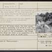
Templestone: This group is interesting on account of its smallness of stones and its being more rectangular than circular. Of the large, erect stones, the NE is a bouldery stone, evidently having fallen forward and now only about 10" above ground. The NW is a pyramidical block of sandstone 2'3" in height; the SW is 4'7" high of quartzitic sandstone; the SE is 2'6" high of quartzitic whinstone.
'A','B','C' and 'D' on the plan are earthfast and seem to be integral to the arrangement. The number of small stones lying loose in the interior seem to indicate exploration, but the results are not known.
F R Coles 1907.
An unusual setting of stones, as planned and described by Coles, although the stone marked 'D' has been removed and may be the stone now lying between the NE and SE corner stones (see amended plan above). Though neither a stone circle nor the chamber of a cairn, its true nature could not be ascertained.
Re-surveyed at 1/2500.
Visited by OS (RD) 6 August 1965
A "four poster" on a SW facing slope. The four corner stones form a rectangle measuring 2.3m NW-SE by 2.5m tran- sversely overall. The intermediate stones, as suggested by Coles, appear to be part of the arrangement. The stones are overgrown with whins and there is no suggestion of a platform despite the slopes shown on Coles' plan.
Visited by OS (AA), 28 April 1971.
Four Poster.
Information from H A W Burl, 9 November 1970
Included in list of 'Four-posters'.
H A W Burl 1971.
Field Visit (6 August 1965)
An unusual setting of stones, as planned and described by Coles, although the stone marked 'D' has been removed and may be the stone now lying between the NE and SE corner stones (see amended plan above). Though neither a stone circle nor the chamber of a cairn, its true nature could not be ascertained.
Re-surveyed at 1/2500.
Visited by OS (RD) 6 August 1965
Field Visit (28 April 1971)
A "four poster" on a SW facing slope. The four corner stones form a rectangle measuring 2.3m NW-SE by 2.5m tran- sversely overall. The intermediate stones, as suggested by Coles, appear to be part of the arrangement. The stones are overgrown with whins and there is no suggestion of a platform despite the slopes shown on Coles' plan.
Visited by OS (AA) 28 April 1971
Reference (1971)
Four Poster.
Information from H A W Burl, 9 November 1970
Included in list of 'Four-posters'.
H A W Burl 1971
Watching Brief (18 December 2017)
A watching brief was conducted in December 2017 for a new house and associated services at Easter Castlehill, Biervie, Forress, the site lying to the North-East of Templestone Stone Circle (NRHE NJ05NE 4). Work revealed no archaeological features or deposits to the development area, the site lying on a slight Southwest-facing slope with an extensive area of underlying bedrock.
Full Report submitted to Moray SMR and NRHE.
Information from Stuart Farrell

