
Feabuie


Farmstead (Period Unassigned), Kiln Barn (Period Unassigned), Lime Kiln (Period Unassigned), Pen (Period Unassigned)
Site Name Feabuie
Classification Farmstead (Period Unassigned), Kiln Barn (Period Unassigned), Lime Kiln (Period Unassigned), Pen (Period Unassigned)
Alternative Name(s) Tornabirrack
Canmore ID 117011
Site Number NJ02NE 19
NGR NJ 06574 26552
Datum OSGB36 - NGR
Permalink http://canmore.org.uk/site/117011


- Council Highland
- Parish Abernethy And Kincardine
- Former Region Highland
- Former District Badenoch And Strathspey
- Former County Inverness-shire
NJ02NE 19 06574 26552
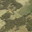
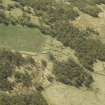
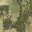
A farmstead comprising one unroofed, two roofed buildings and an enclosure is depicted on the 1st edition of the OS 6-inch map (Inverness-shire 1872-4, sheet xxxv). Two unroofed buildings are shown on the current edition of the OS 1:10000 map (1975).
Information from RCAHMS (SAH) 17 July 1996.
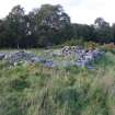
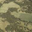
This farmstead, which is situated in rough pasture about 300m SW of Feabuie, comprises three buildings (one of them a kiln barn) arranged around a yard, and three enclosures. The building on the SE side of the yard measures 13.3m from NNE to SSW by 5.1m transversely over stone walls that still stand up to 1.5m in height. There are two entrances in the ESE side. The building on the NW side of the yard measures 13.2m from NNE to SSW by 4.5m transversely over walls up to 0.8m in height. The interior contains two compartments, the N one has an entrance in its ESE side, and the S one has an entrance on the WNW. The kiln barn lies on the NE side of the yard. Subrectangular on plan with a rounded NE end, it measures 11m from NE to SW by 4.8m transversely over grass-grown wall-footings. The NE part of the building contains the kiln-pot, which measures about 2m in internal diameter by at least 0.5m in depth. The SW part of the barn contains a rectangular compartment with an entrance in its SE side.
In addition to the buildings depicted on the 1st edition of the OS 6-inch map (Inverness-shire 1874, sheet xxxv), there are the footings of a small rectangular building 12m SE of the kiln barn. It measures 8.5m from NE to SW by 3.3m transversely overall and may be open-ended on the SSW. A small pen has been built in its N corner. The remains of a limekiln, which has been set into a NW-facing slope, is visible in woodland 35m W of the farmstead. The kiln-pot, which is choked with rubble and has been disturbed by the roots of a now fallen tree, measures 2m in diameter by at least 0.8m in depth. The draw-hole, which was probably on the NW, is no longer visible.
The 2nd edition of the map (Inverness-shire 1903, sheet xxxv) depicts a small roofed building on the SW side of the yard, which is not shown on the earlier map. It was not positively identified on the date of visit.
Visited by RCAHMS (TIP, AGCH) 26 September 2006.

