
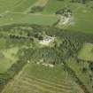
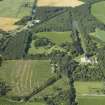
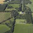
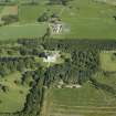
Brodie Castle, Walled Garden


Nursery Garden (Period Unassigned), Walled Garden (Period Unassigned)
Site Name Brodie Castle, Walled Garden
Classification Nursery Garden (Period Unassigned), Walled Garden (Period Unassigned)
Alternative Name(s) Brodie Castle Policies
Canmore ID 105387
Site Number NH95NE 10.01
NGR NH 98150 57900
NGR Description Centred NH 98150 57900
Datum OSGB36 - NGR
Permalink http://canmore.org.uk/site/105387


- Council Moray
- Parish Dyke And Moy
- Former Region Grampian
- Former District Moray
- Former County Morayshire
NH95NE 10.01 centred 9815 5790
Field Visit (September 2013 - April 2014)
B17a Inner Garden Walls
Low (c1.2-1.5m) rubble-stone walls with copes of various styles and gateways and gates in different styles, the development of which can be traced through the plans from 1770 onwards, although the basic outline in plan has changed little.
Individual features
Inner garden wall, south perimeter, general
Low (c.1.2m high) rubble-built wall with cope slabs with slightly rounded tops; first appears on 1870 OS, but likely during estate improvements after c.1824.
Garden entrance / claire voie 1
At junction of wall and SE corner of the castle the garden wall stops short and there is a section of iron fencing with a gate within; defined by masonry pier to east.
Garden entrance / claire voie 2
Formed within the south perimeter of the inner garden wall; rusticated square masonry piers with moulded base and capital. Ashlar footing running between with iron fencing and paired iron gates at centre; ironwork painted green.
Pier at east end of SE perimeter wall
Masonry pier, crudely rebuilt comparatively recently, stones now cement bedded. Cope stone fallen nearby.
Inner garden wall, SE perimeter, general
Granite rubble-built wall some 1.5m high, mono-pitch wall-top sloping inwards; shown on 1770 plan; some sections now broken down
Gated entrance within SE perimeter
Probably a secondary insertion; piers rise to square cap slabs and low pyramidal copes. Iron gate within, after c1824.
Inner garden wall, NW perimeter, general
Granite rubble-built wall some 1.5m high, rough-hewn half-rounded copes further to NE; further to SW wall top detained with a mono-pitch wall-top sloping inwards.
Gated entrance within NW perimeter towards NE end
Probably a secondary insertion, piers rise to square cap slabs and low pyramidal copes. Iron gate within, after c1824.
Gated entrance within NW perimeter
Perhaps originally pedestrian, subsequently widened for vehicle access although not shown on 1870 or 1904 OS; probably modern though NE pier recycles rusticated dressings with low pyramidal cap; SW pier formed of rough-sewn vertical slab of granite, perhaps from a field entrance, surmounted by a low pyramidal cap.
A section of the wall crudely rebuilt, cement-bedded, to circumvent a tree.
Inner garden wall, SW perimeter, general
Short return section of walling extending to coach house to rear of castle; granite rubble construction, about 1.5m high.
Vehicle entrance within SW perimeter wall
Comparatively recent, rough-hewn blocks for jambs, with half-rounded copes –a widening to the SE of a pre-existing pedestrian entrance (stones of SE jamb cement-bedded)?
B17b Outer garden walls
High (c3.0m) granite rubble-stone walls with flat copes on the north-west and northeast sides of garden, and a lower wall on the south-east (1.5m to 2.0m high).
Individual features
Outer garden wall, SE perimeter, general
Granite rubble-built wall some 1.5m high, mono-pitch wall-top sloping inwards; shown on 1770 plan; some heightening at NE end
Outer garden wall, NE perimeter, general
Rubble-built, mixed stone types; evidence for heightening in granite rubble, with flat cope stones, to about 3m high
Entrance in central part of NE wall
Inserted at time of wall heightening; neatly cut dressings with low arched lintel, chamfered; droved tooling beyond 5cm approx. margin; mid-late 19th century.
Outer garden wall, NW perimeter, general
Granite rubble-built, about 3m high, with flat copes; possibly built in two stages.
Entrance in central part of NW wall
Jambs formed of dressings detailed with chamfered arises, suggesting the
feature to be of comparatively early date. Upper jambs and head crudely rebuilt, with some brick and timber lintel.
B17c Former garden walls or boundaries
When the 1770 Brown plan is rescaled and layered with the OS digital plan
and RS survey major features correspond very precisely including the line of the garden walls on the south-east and north-east and features within the garden (see overlays plan above). From this it appears that the outer enclosure line has changed along much of the north-west boundary and at the castle end of the south boundary. The original boundary appears to have run on the north side of the drive outside the present wall and to have been a hedge, possibly also with a fence, as depicted by Brown, the drive then acting as a perimeter path within the garden. This 1770 enclosure was identified by Murray Archaeological Services during recent excavations in advance of the new playground construction. All of
the present wall and garden buildings lie within the early boundary line.
Changes in the south wall line are more obvious, changing from a stepping and curving line alongside the east vista until joining the bowling green enclosure, as shown by Brown, to a straight line parallel with the East drive to the east corner of the enlarged castle on the 1870 OS and today. All of the south boundary appears to be depicted by Brown as hedge with fence, changing to fence only close to the castle, with only the north wall close to the castle and the east boundary walled.
(BRD14 B17)
Standing Building Recording (13 May 2014)
Prior to its removal, a standing building survey was undertaken on a collapsing early 20th -century glasshouse built against the NE wall of the walled garden at Brodie Castle. The structure can be identified as a three-quarter-span peach house bought from MacKenzie and Moncur in 1912, a major manufacturer of glasshouses based in Edinburgh, Glasgow and London. Much of the glass, parts of the low brick foundation and the winding mechanism for the windows in the N half had been removed for re-use elsewhere. However most of the timber framework and the cast iron brackets and the winding mechanism for the S end windows survived and were recorded.
Information from OASIS ID: mas1-207297 (J C Murray) 2014

