
Tullochgorm


Chambered Cairn (Neolithic)
Site Name Tullochgorm
Classification Chambered Cairn (Neolithic)
Alternative Name(s) Lagyie
Canmore ID 15443
Site Number NH92SE 3
NGR NH 9648 2130
Datum OSGB36 - NGR
Permalink http://canmore.org.uk/site/15443


- Council Highland
- Parish Duthil And Rothiemurchus
- Former Region Highland
- Former District Badenoch And Strathspey
- Former County Inverness-shire
NH92SE 3 9648 2130.
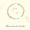
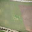
(NH 9648 2130) Stone Circle (NR)
OS 6"map, Inverness-shire, 2nd ed., (1903)
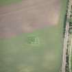
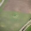
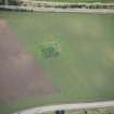
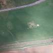
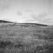
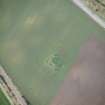
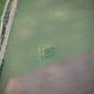
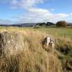
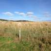
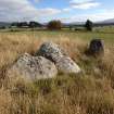
A Clava cairn, greatly robbed though the greater part of the kerb still exists, outside which is a considerable bank of cairn material.
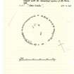
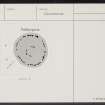
Within the centre are five stones, apparently earth-fast, but some probable monoliths are situated at similar distances (ie. 16') from the kerb on the N and NE sides.
A S Henshall 1963, visited 1957.
The remains of a Clava-type cairn as described and planned by Henshall.
Visited by OS (NKB) 16 September 1966.
Field Visit (25 September 1943)
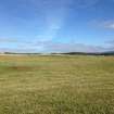
What the OS map calls a ‘Stone Circle is situated between the LMS Forres-Aviemore line and the main road from Grantown-on-Spey to Aviemore, about 50yds from the 7th milestone and ¼ mile E of Lagyie[Lackgie] farmhouse. The site is the end of a sandy ridge a little above the 700’ contour. The ‘circle’ is a ring of close-set boulders and recalls the peristalith of a chambered cairn of Clava type. Only 35 boulders are actually visible, and of these several are more or less out of position. A typical specimen on the E measures 3’3” in height (a rabbit burrow has exposed its base) x 2’9” wide x 1’8” thick, but the stones on the N are somewhat smaller while those on the SW are noticeably larger than the rest. The two largest stones are on the SW and, there being an apparent gap of 5’6” between them, they look like portals. That on the E, still in position, rises 2’9” above the surrounding ground, is 3’3” wide tangentially and 2’ thick radially. The opposite stone, on W, is leaning inwards and exceeds 4’ in real height by 2’9” in width and 1’8” in thickness. The apparent gap is, however, partially filled by a broken slab 2’9” wide and over 1’ thick the upper edge of which is now covered with turf. Just beyond the W portal there is, instead of a boulder, another very large slab, over 2’8” high x 3’4” x over 1’3” that is now leaning inward. Slabs take the place of boulders at three other points upon the circle. The diameters of the circle are 45’ N-S and 47’ E-W. The interior of the circle is 6” to 18” higher than the sandy ground outside, and is now occupied by very deep turf through which the edges of 4 large slabs protrude. These may well have formed part of the wall of a chamber, as their inner faces are noticeably smooth and straight. The northernmost is however certainly out of position, lying rather in its side, and the arrangement of the rest is too doubtful to allow of the form of the chamber being recovered. A few cairn stones are lying just outside the peristalith, but no free-standing outer circle survives. Nevertheless, having regard to the nature of the site, the character of the architecture and the proximity of the well-known group of cairns at Avielochan and Aviemore, it seems probably that this monument should be classes with the chambered cairns of the Clava type.
Visited by RCAHMS (VGC, AG) 25 September 1943
Map ref: xlvi (‘Stone Circle’)

