
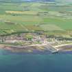
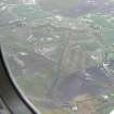
Fearn Airfield


Air Raid Shelter(S) (20th Century), Aircraft Hangar (20th Century), Building(S) (20th Century), Nissen Hut(S) (20th Century)
Site Name Fearn Airfield
Classification Air Raid Shelter(S) (20th Century), Aircraft Hangar (20th Century), Building(S) (20th Century), Nissen Hut(S) (20th Century)
Alternative Name(s) Hms Owl; Loans Of Rarichie
Canmore ID 114467
Site Number NH87NW 21.02
NGR NH 8499 7610
NGR Description Centred NH 8499 7610
Datum OSGB36 - NGR
Permalink http://canmore.org.uk/site/114467


- Council Highland
- Parish Fearn
- Former Region Highland
- Former District Ross And Cromarty
- Former County Ross And Cromarty
NH87NW 21.02 Centred 8499 7610
Also falls on map sheet NH87NE
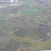
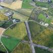
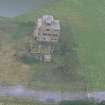
The technical area for Fearn Airfield is situated immediately to the E of the control tower (NH87NW 21.01) and it extends to the public road (B9166) which falls on sheet NH87NE. Within this area are three Nissen huts joined together to form the torpedo store (NH 84941 76061), several buildings and sheds now being used as modern industrial units, one of which is a Mainhill 'S' type hangar and the remains of many air-raid shelters, ablutions blocks and other buildings.
The technical area reflects the mixed ancestry of this airfield, with buildings from two periods, that of the RAF and the later RN post 1942 history. During Fearn Airfields naval period it was the torpedo school, with the nearby Tain bombing range (NH88SW 14.01) being used for practice.
Visited by RCAHMS (DE) January and May 1997

