
Meikle Ferry, West Pier


Pier (Period Unassigned)
Site Name Meikle Ferry, West Pier
Classification Pier (Period Unassigned)
Alternative Name(s) Ferery Point; Ness Of Portnaculter; Ness Of Portnaculter; Dornoch Firth
Canmore ID 14666
Site Number NH78NW 31
NGR NH 73212 85922
Datum OSGB36 - NGR
Permalink http://canmore.org.uk/site/14666


- Council Highland
- Parish Tain
- Former Region Highland
- Former District Ross And Cromarty
- Former County Ross And Cromarty
NH78NW 31 73212 85922
Pier [NAT]
OS (GIS) MasterMap, June 2009.
Formerly entered as Meikle Ferry, South West Pier at cited location NH 732 859.
For Ferry, see also NH78NW 34.
For corresponding pier on the N side of the Dornoch Firth, at Meikle Ferry or Ferrytown, see NJ78NW 28.
For East Pier (NH 73242 85931), see NH78NW 65.
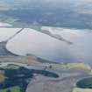
(Location cited as NH 732 859). Pier, Meikle Ferry, early 19th century. A ramped ferry pier of coursed-rubble construction. Now a private pier used by a fishery.
J R Hume 1977.
The pier associated with the south side of the former Meikle ferry crossing the Dornoch Firth.
J Wordsworth, SSSIs, Scottish Natural Heritage, 1993.

