
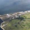
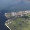
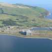
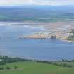
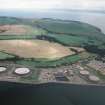
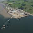
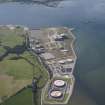
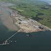
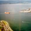
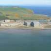
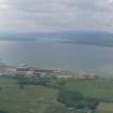
Nigg Ferry, Oil Platform Fabrication Yard


Platform Fabrication Yard (20th Century)
Site Name Nigg Ferry, Oil Platform Fabrication Yard
Classification Platform Fabrication Yard (20th Century)
Alternative Name(s) Cromarty Firth; Firth Of Cromarty; Nigg Sands; Nigg Ferry
Canmore ID 14477
Site Number NH76NE 52
NGR NH 790 695
NGR Description Centred NH 790 695
Datum OSGB36 - NGR
Permalink http://canmore.org.uk/site/14477


- Council Highland
- Parish Nigg (Ross And Cromarty)
- Former Region Highland
- Former District Ross And Cromarty
- Former County Ross And Cromarty
NH76NE 52 centred 790 695
Fabrication Yard [name: NH 789 694]
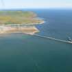
Graving Dock [name: 792 691]
Pier [name: NH 784 689]
OS 1:10,000 map, 1983.
Fabrication Yard [NAT]
OS (GIS) MasterMap, May 2010.
Location formerly entered as NH 79 69.
Fabrication yard; oil industry; addition of helipad - reclaimed land, stable condition.
CFA/MORA Coastal Assessment Survey 1998.
Now in use for the manufacture of offshore wind turbines.
Information from RCAHMS (RJCM), 3 May 2010.

