
Cromarty, Flying Boat Base


Seaplane Base (20th Century)
Site Name Cromarty, Flying Boat Base
Classification Seaplane Base (20th Century)
Alternative Name(s) Royal Naval Air Station, World War 1; Cromarty Firth; Cromarty, The Links; Firth Of Cromarty
Canmore ID 173657
Site Number NH76NE 295
NGR NH 7885 6767
NGR Description Centred NH 7885 6767
Datum OSGB36 - NGR
Permalink http://canmore.org.uk/site/173657


- Council Highland
- Parish Cromarty
- Former Region Highland
- Former District Ross And Cromarty
- Former County Ross And Cromarty
NH76NE 295 centred 7885 6767
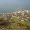
Not to be confused with the World War II Royal Air Force seaplane and flying boat base (RAF Alness) on the Cromarty Forth (centred NH 6512 6790), for which see NH66NE 52.00.
The World War I sea plane base for the Cromarty Firth was situated on an area now known as The Links on the NE side of Cromarty. At low water it is possible to see the remains of the wooden slipway supports for the flying boats. Little other remains can be seen.
J Guy 2000; NMRS MS 810/10, Vol.2, 90; Airfield Focus 31 (Invergordon)

