
Milton Of Clava North


Burial Cairn (Neolithic) - (Bronze Age), Stone Circle (Neolithic) - (Bronze Age)
Site Name Milton Of Clava North
Classification Burial Cairn (Neolithic) - (Bronze Age), Stone Circle (Neolithic) - (Bronze Age)
Canmore ID 14281
Site Number NH74SE 6
NGR NH 75246 43974
Datum OSGB36 - NGR
Permalink http://canmore.org.uk/site/14281


First 100 images shown. See the Collections panel (below) for a link to all digital images.
- Council Highland
- Parish Croy And Dalcross (Inverness)
- Former Region Highland
- Former District Inverness
- Former County Inverness-shire
NH74SE 6 75246 43974.
(NH 7524 4396) Stone Circle (NR) (Remains of)
OS 6"map, Inverness-shire, 2nd ed., (1906)
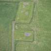
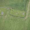
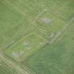
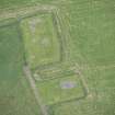
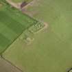
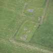
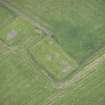
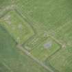
This Clava-type cairn, one of the Clave cemetery group, lies like the other s in a field on the valley floor. The cairn appears to have been already greatly ruined in 1857 (Innes 1862). The only notable feature is a large rectangular monolith, 7 feet 10 inches high which seems to have stood on the south or south-west side of the monument. About 10 feet 9 inches from the monolith are two contiguous stones, the larger 2 feet high, which probably represent the remains of the kerb. To the north of them is a low mound of cairn material and field stones evidently extending beyond the area of the original cairn. In 1882 there were four stones of the kerb to be seen and one stone of the inner setting (Jolly 1882).
C Innes 1862; W Jolly 1882; J Fraser 1884; A S Henshall 1963, Visited 21 April 1958.
The remains of the cairn are as described above.
Revised at 1/2500.
Visited by OS (W D J) 25 April 1962.
Air photographs, taken by Jill Harden in 1989, are in Inverness Museum (8907.03-05 INVMG).
Information from J Harden 1989.
Three trenches were deturfed and cleaned. These revealed a circular cairn of small stones overlain by rectangular cairn of much larger water worn boulders. The latter forms the principal visible feature today and is probably the result of modern field clearance. The former is only partially visible as a low turf-covered mound and probably represents a Clava cairn. The identification of the site as a Clava cairn is based on its shape, size (c10m in diameter), the standing stone situated to the the SW and the presence of a kerb defined by large boulders and slabs sitting on the old ground surface. Partial exploration of the cairn revealed no indication of a passage but there was some suggestion of complexity in the cairn construction.
N Sharples 1990a.
Mains of Clava North is now represented by a single standing stone. An area extending for 30m on each side of the monolith was examined by resistivity survey. This resulted in the identification of what was probably a large circular cairn to its N. It seems likely that the monolith once formed part of a circular setting enclosing a cairn roughly the same size as the NE passage grave inside the guardianship enclosure.
R Bradley, 1996
Field Visit (April 1979)
Miltown of Clava, North (INV 43) NH 752 439 NH74SE 6
A standing stone 2.4m high, two possible kerb-stones and a quantity of cairn material represent the remains of a Clava cairn.
RCAHMS 1979, visited April 1979
(Henshall 1963-72, i, 383)

