
Upper Cullernie


Ring Ditch (Prehistoric)
Site Name Upper Cullernie
Classification Ring Ditch (Prehistoric)
Canmore ID 14224
Site Number NH74NW 35
NGR NH 7310 4796
Datum OSGB36 - NGR
Permalink http://canmore.org.uk/site/14224


- Council Highland
- Parish Petty
- Former Region Highland
- Former District Inverness
- Former County Inverness-shire
NH74NW 35 7310 4796
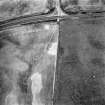
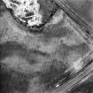
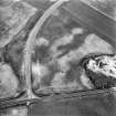
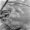
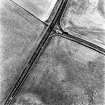
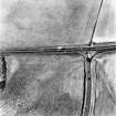
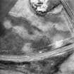
NH 731 479. Air photography has revealed the crop-mark of a ring-ditch 500m NNW of Upper Cullernie farmhouse, immediately S of the Inverness - Nairn road.
RCAHMS 1979; Visible on RCAHMS air photograph IN 3606-7, IN 3609-10.
This enclosure measures about 10m in diameter. There are additional ring-ditches recorded in the surrounding area (see NH74NW 39 and NH74NW 47 ).
Information from RCAHMS (KJ) 13 October 1999.
Note (1979)
Upper Cullernie NH 731 479 NH74NW
Air photography has revealed the crop-mark of a ring-ditch 500m NNW of Upper Cullernie farmhouse, immediately S of the Inverness-Nairn road (A 96).
RCAHMS 1979

