
Blackhill


Palisaded Enclosure (Prehistoric), Roundhouse (Prehistoric)(Possible)
Site Name Blackhill
Classification Palisaded Enclosure (Prehistoric), Roundhouse (Prehistoric)(Possible)
Canmore ID 14221
Site Number NH74NW 32
NGR NH 71643 47892
Datum OSGB36 - NGR
Permalink http://canmore.org.uk/site/14221


- Council Highland
- Parish Inverness And Bona
- Former Region Highland
- Former District Inverness
- Former County Inverness-shire
Air photographs, taken by Jill Harden in 1989, are in Inverness Museum (8905.05-06 INVMG).
Information from J Harden, 1989.
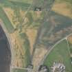
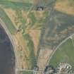
Recent aerial photography (RCAHMSAP 1995) suggests that a narrow palisade defines this enclosure. A crescentic mark measuring about 10m in diameter and visible in the NE side of the interior may represent a roundhouse. There are a number of indeterminate cropmarks and pits scattered across the same field.
Information from RCAHMS (KJ) 13 October 1999.
Note (1979)
Blackhill, NH 716 479 NH74NW 32
Air photography has revealed the crop-mark of an almost circular enclosure 240m SW of Blackhill farmhouse. It measures about 30m in diameter within a narrow ditch. Visible on RCAHMS AP 1977.
RCAHMS 1979
Aerial Photographic Transcription (30 October 1991 - 11 November 1991)
An aerial transcription was produced from oblique aerial photographs. Information from Historic Environment Scotland (BM) 31 March 2017.

