
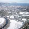
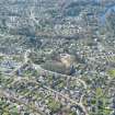
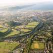
Inverness, Bught Road, General's Well Bridge


Suspension Bridge (Period Unassigned)
Site Name Inverness, Bught Road, General's Well Bridge
Classification Suspension Bridge (Period Unassigned)
Alternative Name(s) Ness Islands Footbridge (1); River Ness
Canmore ID 13534
Site Number NH64SE 50
NGR NH 66114 43610
Datum OSGB36 - NGR
Permalink http://canmore.org.uk/site/13534


- Council Highland
- Parish Inverness And Bona
- Former Region Highland
- Former District Inverness
- Former County Inverness-shire
NH64SE 50 66114 43610
Location formerly cited as NH 6611 4361 and NH 66111 43614.
For (predecessor and original) General's Well Suspension Footbridge (reconstructed at NH c. 6589 4338), see NH64SE 377.
For (counterpart) Ness Bank Footbridge (NH 66449 43903), see NH64SE 51.
F B [NAT]
OS 1:1250 map, 1963.
F B [NAT]
OS 1:10,000 map, 1984.
FB [NAT]
OS (GIS) AIB, April 2006.
(Suspension bridge of James Dredge type: location cited as NH 661 437). Built 1853-4 by James Dredge, engineer. Cast-iron pylons, tapering iron rod chains of Dredge type, iron frame to booms, wooden deck. Main span 97 ft 3 ins (29.6m) Public footbridge.
J R Hume 1977b.
Historic Scotland - delisted 20.3.2000.
(Undated) information in NMRS.
This suspension bridge carries a footpath over the W channel of the River Ness to the NW of the S end of the Ness Islands. Together with the Ness Islands footbridge (NH64SE 51), it allows foot passage across the river via the Ness Islands from Island Bank Road (to the SE) to Bught Road (to the NW).
The location assigned to this record defines the centre of the structure. The available map evidence suggests that it extends from NH c. 66097 43626 to NH c. 66130 43596.
The 1963 edition of the OS 1:1250 map notes The General's Well [NAT] adjacent to the SW.
Information from RCAHMS (RJCM), 12 April 2006.

