
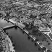
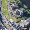
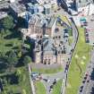
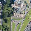
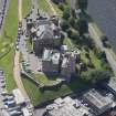
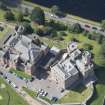
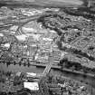
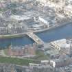
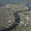
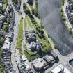
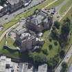
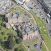
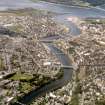
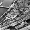
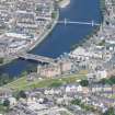
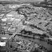
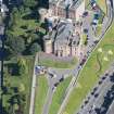
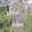
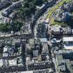
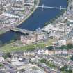
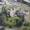
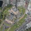
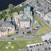
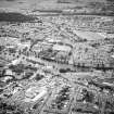
Inverness, Castle Wynd, Castle Hill, Inverness Castle


Castle (Medieval), Prison (19th Century), Wall(S) (19th Century), Well (Period Unassigned)
Site Name Inverness, Castle Wynd, Castle Hill, Inverness Castle
Classification Castle (Medieval), Prison (19th Century), Wall(S) (19th Century), Well (Period Unassigned)
Alternative Name(s) Fort George; Castlehill
Canmore ID 13447
Site Number NH64NE 9
NGR NH 66653 45096
Datum OSGB36 - NGR
Permalink http://canmore.org.uk/site/13447


- Council Highland
- Parish Inverness And Bona
- Former Region Highland
- Former District Inverness
- Former County Inverness-shire
NH64NE 9 6664 4510
(NH 6664 4510) Castle {NR} (Ruin)
OS 25"map, (1868).
Not to be confused with (successor) Fort George at Ardersier (NH 7625 5670), for which see NH75NE 3.
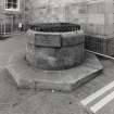
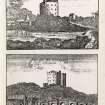
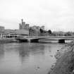
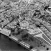
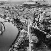
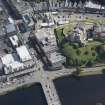
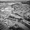
The castle of Inverness, on Castlehill, is said to have been built variously by David I c.1141 (E S Armitage 1912 and Inverness official Guide 1957), or by Malcolm Canmore (11th century) (F R Fappie 1908 and OSA 1793). It has been occupied by Edward I, Bruce, James I, III, & IV, and in 1562 was attacked and razed by Mary, Queen of Scots. It was again almost destroyed by the Royalists in 1649, and was finally destroyed by Prince Charles Edward in 1746. Additions were made to it between 1508 and 1540. All that remains of the old castle is the well, discovered and restored in 1909, the stairway leading to Castle Street, and part of the old rampart wall between Castle Street and the Castle Hill itself. The present County buildings were built on the site in 1834-46 (Inverness Official Guide 1957 and G Eyre-Todd 1923). The original castle was a square tower (R Pococke 1760), and in the reign of George II, the site was transformed into a square by adding barracks on each side and a governor's house on the north side. There was also a chapel and other buildings on the south side of the castle.
R Pococke 1760; Statistical Account (OSA) 1793; J Anderson 1831; J Grahame 1831; F R Frappie 1908; E S Armitage 1912; G Eyre-Todd 1923; Inverness Official Guide 1957.
No trace of antiquity remains about the present buildings on Castlehill, except the well in the courtyard.
Visited by OS (W D J), 1 April 1960.
REFERENCE SRO:
Fortification.
Theodory Dury's report on what is required to put Inverness in a fit state for defence by the building of pallisades.
1690 GD 26/9/111
In the National Library of Scotland is a series of Military Maps and Drawings (many are coloured) of the Board of Ordnance and relating to the Works executed in the disturbed times of the 18th Century.
Included are the following relating to Fort George at Inverness:-
In Case or Volume, No. 1647:-
Number. Year.
Z.2/76. No date. "A Generall Survey of Inverness and the Country
adjacent to the foot of Loch Ness". With Explanation
and view of the Town. Scale 1500 Feet to a Inch. There
are 2 copies.
Z.2/77. 1719 "Inverness". A survey of the Castle Anne 1719. With
References. There is a small plan to scale of 200 Feet
to an Inch, and Plans and Sections to scale of 40 Feet
to an Inch.
Z.2/78 No date "Inverness in North Britain, by Brigdr Petite. Is a
Plan of the Town, with the Castle Hill, and shewing
Oliver's Fort. Scale 200 Feet to an Inch. There are 2 copies.
Z.2/82 1746 "Plan for building a Fort at Inverness on the Vestige
of an Old Fort demolished 1746. With Profile and References. Scale for Plan 100 Feet to an Inch and for
Profile 30 Feet to an Inch. There is a copy.
Z.2/83 1746 "A Plan of a New Fort design'd for Inverness, done
exactly on the old lines of Olivers Fort; with the
additional Outworks of Cover'd-Way, Lunettes & Glassis"
With Explanation. Scale 100 Feet to an Inch. Also
Sections and Profiles to scale of 10 Feet to an Inch. The Blocks are numbered, and both drawings are docketted as "Rec'd with Major Lewis Marcell's Report
& Estimate dated 1746"
Z.2/79 1746 "Elevation of the Main Gate or Entrance on the Rampart
to the Fortress". Docketted as "Received with Major
Lewis Marcell's Report & Estimate for building a Fort
at Inverness 1746".
Z.2/80 1746 "Plans Elevation and Section of one of the four long
Piles of Barracks for Soldiers". Scale 15 Feet to an Inch. Docketted as last. Marked 9 on General Plan 2/83
Z.2/80 1746 "Plans Elevation and Section of the Officers and Soldiers Guard Rooms, Brewers, Stables, &c". Scale as last and docketted as last. Marked 7 & 8 on General
Plan Z.2/83
Z.2/81 1746 "The Governeur's, Deputy Governeur's, Fort Major's &
Store Keeper's Houses". Docketted as 2/79. Marked Nos 1 and 2 on the General Plan Z.2/83.
" " "Plans Elevation and Section of the Powder Magazine.
Magazines for provisions, Baking Houses, &c". Scale
and docket as before. Marked No. 3 on the General Plan.
" " "Plans Elevation and Section of the Arsenal & Armoury".
Scale and docket as before. Marked No. 4 on General Plan
" " "Plans and Elevation and Section of the Hospital". Scale and docket as before. Marked No. 5 on the General
Plan.
" " "Plans Elevation and Section of a Pile of Barracks for Soldiers. Scale and docket as before. Marked No. 6 on
General Plan.
In Case or Volume, No.1646, are:-
Z.2/33. 1730 "A Plan and Section of Fort George with Part of the
Town of Inverness, 1730". With Profile and with
Explanation. Scale nearly 1 over 500. Bears the name J.Remer. There are 2 copies.
Z.2/34. 1732 "A Plan of Fort George & Part of the Town of Inverness,
with propoer Sections relating to the Fort, surveyed and projected by John Remer, Anne 1732". With Elevations and Sections, and with Explanantion. Scale
for General Plan 100 Feet to 1 Inch and two-twelfths, and for Sections 20 Feet to an Inch. There is a copy.
Z.2/35. 1739 "A Sketch of Fort George 1739", Inverness, shewing
a breaching of the retaining Wall at River side.
Marked as received from Captn Remer.
Z.2/36. 1750 "Plan of Fort George at Inverness shewing its present
position 1750". With Explanation. Scale 20 Feet to an
Inch. Surveyed and drawn by Chas. Tarrant, and signed
W.Skinner. There is a copy.
Z.2/37. No date "Sections of Fort George, Inverness with part of the Town of Inverness". Scale 20 Feet to an Inch. Taken and
drawn by Chas. Tarrant. Signed W.Skinner. There is one
copy.
Z.2/38. No date "A Plan and Section of Fort George with part of the
Town of Inverness". with a small Section, and with
an Explanation. Sclae for Section 40 Feet to an Inch.
No date, but considered prior to 1750.
There is also, in Case, or Volume, No.1646, this Drawing:-
Z.2/31. No date Small Plans of Fort William, Fort Augustus, and Fort George (Inverness), on the one sheet.
This one is also indexed under Fort William and Fort
Augustus.
REFERENCE: Scottish Record Office
The condition of the Castle of Inverness.
The Lord Advocate is averse to demolition in spite of the Castle going 'a complete ruin'. An interdict is passed to prevent the Duke of Gordon demolishing it. Meanwhile Mr Campbell is to inspect and report.
1777 GD 44/Sec 22/Bundle 31
Report on the condition of the Castle of Inverness.
Ilay Capbell suggests that the East Wing should remain as it was, as the people of Inverness think it ornamental.
1777 GD 44/Sec 22/Bundle 31
The removal of stone from the Old Castle and its ramparts.
A list of people of Inverness, guilty of carrying off the materials of the Castle with a note of what each person has built with what was taken.
1777 GD 44/Sec 22/ Bundle 31
Inverness. Painting of Inverness Castle.
Petitions to Queen Anne by George 4th Marquis of Huntly. narrates that the Garrison put into Inverness Castle after the Revolution in 1688 'defaced the painting of the castle which was done by Italian-masters at the sole expence of the Earls of Huntly'.
GD 44/22/31
Damage to the Castle by a Garrison of Foot [1688] 'The said Garrison without regard to any law civil or military first defaced the painting of the Castle which was done by Italian masters at the sole expense of the Earls [? Marquesses] of Huntly then tore down the wainscott lining of the rooms, pulled up the flooring and tho' of no use to themselves and tho' it required some labour too they cull the very Beams and Joists and With Great Iron Hammers broke down the steps of the Great Stair of the Castle tho' made of stone...'
Petition, Marquess of Huntly to Queen Anne
(ND) GD44/22/31/20
Upkeep of Inverness Castle
The Family of Gordoon kept this Castle in great repair and were at considerable expense in decorating it with Italian Paintings and other ornaments suitable to their rank till about 1688 when the exigency of the times made it expedient for the government to take possession of this Fort'
Memorial for His Grace the Duke of Gordon
1777 GD44/22/31/5
Inverness. Repair of the Barracks and Castle of Inverness.
An Account of the expense.
ND [?1715] GD 220/6/1752/21
A rough Plan of the Castle of Inverness, with what ground can be taken in to make defences for a regiment of foot, consisting of 600 men.
ND [?1715] GD 220/6/1752/20
Removal of the stones of the Castle.
Peition to the Sheriff and complaint from the Magistrates against Capt. Alexander Godsman [The Duke of Gordon's Factor at Dunain] followed by a Summons for demolishing and taking away stone from the Castle.
1777 GD 128/6/2
Removal of the stones of the Castle.
In a Bill of Advocation the Duke of Gordon replied that after 1745 the Castle, having been blown up with gunpowder, was demolished. Since then it had been of little use except as a quarry. The inhabitants of Inverness had pilfered the stone so the Duke had ordered his Factor, Alexander Godsman, to use the stone to enclose the Duke's land adjooining the Castle.
1777 GD 128/6/2
Report on the condition and demolition of the Castle.
The Easter Gavell is reported to be in dangerous state but no more so than it was before the operation of digging by order of Alexander Godsman, the Duke of Gordon's Factor at Dunain. Robert Duncan in his report accepts that Godsman's method of taking down what remained of the Castle is the only safe one.
1783 GD 128/6/2
NMRS REFERENCE
Inverness, Fort George
'In 1724......
some time after 1724 when Wade was Commander-in-Chief in Scotland, new works were raised round Inverness Castle which became the first Fort George. In 1948 a new fort was begun at Ardersier, the new Fort George.
(Undated) information in NMRS.
Publication Account (1977)
The castle at Inverness dates from the period of William the Lion's ll79 campaign in the North and is in all likelihood a David I erection (Barrow, 1960, 44) Castle and burgh both had a stormy history in the middle ages. Captured by Bruce in 1308 (Barrow, 1965, 279), the castle was refurbished in 1362 when news of war was imminent, and was used for sheriff courts in the last half of the fourteenth century. Accounts for 1412-1415 in the Exchequer Rolls suggest that the Earl of Mar rebuilt the castle at Inverness, including turrets and a stone surrounding wall. In 1508 the third Earl of Huntly was given a commission as justiciar of the North and ordered to carry out improvements on the castle, including the construction of a hall, kitchen and chapel. This project was not, however, carried out until 1540 (Macdonald, 1895-1899, 278). Although garrisoned for a short time by Hanoverian troops after the '15, it was described by Captain Burt in 1735 as being ruinous. Jacobite rebels in 1746 blew up the castle. The present castellated structure on Castle Hill was built between 1843 and 1836. All that remains of the previous castles is a well, discovered in 1909, the stairway leading to Castle Street and part of the rampart wall between Castle Street and the Castle Hill itself (Ordnance Survey, Record Cards, Reference NH 64 NE 9).
Information from ‘Historic Inverness: The Archaeological Implications of Development’ (1977).
Archaeological Evaluation (27 July 2020 - 31 May 2021)
NH 66639 45103 An initial phase of archaeological works was carried out at Inverness Castle, Inverness, in respect of internal alterations, ground investigations, enabling works and the demolition of a single-story cell-block. The present-day buildings are category A-listed (LB35166).
The archaeological works were carried out between July 27 2020 and May 31 2021. The evaluation uncovered walls that comprised the 19th-century prison exercise yards and some sparse evidence for older underlying deposits. The watching brief comprised the monitoring of over 130 small hand-excavated trial pits, two major trial pits to investigate the castle curtain wall foundations, and the excavation of four trenches within the courtyard of the current Castle buildings. The deepest deposits on site were uncovered with the excavation of the wall trial pits and revealed disturbed midden deposits at a depth of 5m below the ground surface, which included shell and animal bone and disarticulated human remains. The additional trenches within the courtyard identified a portion of wall that predates the current 19th-century buildings on site, as well as a vehicle inspection pit and brick culvert likely associated with the 1960s police station based in the former prison.
A moderate assemblage of 19th-century or later artefact material comprising ceramics, glass, ferrous and other metal objects, slate and other building material, was recovered. An additional watching brief is required for further works on the Castle and is to be undertaken, along with further survey work to document the interior of the buildings prior to renovation works. A programme of post-excavation work has been recommended.
Archive: NRHE (intended)
Funder: LDN Architects on behalf of Highland Council
Sam Williamson – AOC Archaeology Group
(Source: DES Vol 22)

