
Ord Hill, Kessock


Fort (Prehistoric), Vitrified Stone (Prehistoric)
Site Name Ord Hill, Kessock
Classification Fort (Prehistoric), Vitrified Stone (Prehistoric)
Alternative Name(s) Ord Of Kessock
Canmore ID 13389
Site Number NH64NE 37
NGR NH 66392 49097
NGR Description Centred on NH 66392 49097
Datum OSGB36 - NGR
Permalink http://canmore.org.uk/site/13389


- Council Highland
- Parish Knockbain
- Former Region Highland
- Former District Ross And Cromarty
- Former County Ross And Cromarty
NH64NE 37 6640 4910
(NH 6640 4910) Fort (NR)
OS 25" map, (1968).
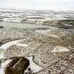
A vitrified fort enclosing an area about 265.0m NE-SW by 115.0m on the rocky uneven summit of afforested Ord Hill. Except at the strengthened SW approach, vitrifaction can be seen intermittently around the whole periphery. The wall is mainly overgrown with turf and trees, but the base course of the outer wall face is visible in the ESE, and also in the W where one probable inner facing stone gives a wall thickness of 3.5m. For a distance of 80.0m in the E, the wall is not evident, but a terrace probably represents part of its course. The easiest approach in the SW is blocked by two curving walls of bare rubble stones, the outer spread to c.6.0m, and the inner to c.8.0m. No wall faces or vitrifaction are evident, and it is uncertain whether they are original or whether they represent a secondary defence. There are gaps at either end of these walls, which probably represent two entrances, but these are obscured by tumble in the case of the NE one, and by a forestry bank in the case of the other. The three alleged hut circles, each c. 10' in diameter, which were noted by Woodham (A A Woodham 1956) just inside the entrance, are fortuitous arrangements of tumble from the wall.
T Wallace 1921; R W Feachem 1963; Visited by OS (NKB) 10 December 1970.
Outside the double defence in the SW is a fragment of another overgrown wall which is probably part of an outwork giving further protection to this vulnerable quarter. It is not vitrified.
Visited by OS (AA), 16 April 1974.
Field Visit (12 April 1957)
Fort, Ord Hill, Kessock
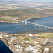
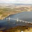
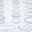
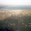
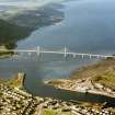
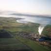
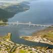
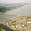
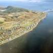
This fort occupies the summit of the Ord Hill, a conglomerate ridge which rises to a height 633 feet O. D. immediately N of the narrows at the entrance of t he Beauly Firth. The hill forms a natural pair with Craig Phadrig (NH64NW 6), three miles to the SE, but is both higher and longer. At the date of visit the whole hill was planted with well-grown conifers of no great age and the remains of the fort were measured only with some difficulty. The fort, which i s irregularly sub-rectangular on plan with comparatively straight long sides, measures about 900 feet in length from NE to SW by about 230 feet in maximum width within the ruin of a substantial stone wall. For most of its length this appears as a spread of blocks and stones which varies in that many of these have fallen down the steep NW and SE flanks of the hill. I n particular there are several gaps where no traces of the wall can be seen i n the vicinity of the steepest part of t he SE flank. The best -preserved sectors of the wall are those that enclose the SW quarter of the fort; they lie on comparatively level ground the approach to which is not difficult, and it is probable therefore t hat they were constructed, or reconstructed, to provide a mor e formidable barrier than was necessary at the crest of the steeper slopes bordering the rest of the perimeter. The entrance lies in the S corner. At a point in the SE sector of the wall at a distance of between 30 yards and 40 yards NE of the entrance a stretch of solid vitrifaction, apparently consisting , of wall blocks fused to each other, and to the conglomerate below them, was seen on the day of visit. The magnitude and extent of this vitrified mass suggests that the fort was probably originally formed by a heavy timber laced wall and may have been comparable i n size and strength to the largest of t his class in the region. To W and NW of the entrance the wall assumes a different appearance, consisting of two virtually parallel broad bands of tumbled blocks and stones which lie about 30 feet apart and are each spread to a width of about 20 feet or 25 feet. The inner of these two stretches forms the first 60 yards of the main wall as this leaves the W side of the entrance, and the outer covers it for this distance before dying out on the steep NW flank of the hill. The precise arrangement of the three walls near t he entrance was difficult t o trace on the day of visit because of vegetation and fallen branches, but it appears to be as shown on the sketch plan (RCD 1/1). Three hut circles each about 10 feet in internal diameter that lie close to the ruin of the wall in the S may be comparatively recent in date.
NH 663 491, OS Sheet c.
Visited by RCAHMS 12th April 1957
Field Visit (January 1978)
Ord Hill, Kessock NH 664 491 NH64NE 37
This large fort occupies the summit of Ord Hill and is covered by a forestry plantation. It measures 275m by 71 m within a vitrified wall which is up to 3.5m thick. The entrance ison the SSW and has been protected by two outworks.
RCAHMS 1979, visited January 1978
MS notes in NMRS, RCAMS Survey of Marginal Lands; Woodham 1956, 81, no. 46;
Feachem 1977, 148
Ground Survey (21 June 2011 - 22 June 2011)
NH 5045 5850 and NH 6640 4910 A detailed topographic survey was undertaken 21–22 June 2011 of two Pictish forts on the Black Isle. These were Knock Farril, near Dingwall and Ord Hill, near North Kessock. The surveys provided a baseline record of the earthworks and surviving structural features of the forts. This data will be used in any future access and interpretation initiatives and assist with conservation management of the sites.
Both forts are situated on very prominent ridges and would have offered commanding views over their respective surroundings. Substantial remnants of (at least) partly vitrified enclosure walls and outworks are still visible at each site. There were no clear signs of contemporary internal features in either fort. The sites currently provide very different visitor experiences. Knock Farril offers clear views of both the environs and the layout of the fort, while Ord Hill’s afforested summit makes comprehension of the site and its setting more difficult.
Archive: RCAHMS
Funder: Forestry Commission Scotland
Headland Archaeology Ltd, 2011
Note (12 March 2015 - 1 June 2016)
This large fort occupies the summit of Ord Hill, the ridge of high ground commanding the N side of the narrows at the mouth of the Beauly Firth opposite Inverness. Irregular on plan and roughly following the contours of the hill, it measures about 265m from NE to SW by a maximum of 110m transversely within a wall that forms a mound of rubble some 6m thick where it is best preserved on the relatively easy line of approach along the spine of the ridge on the SW. Elsewhere its line is more difficult to follow, but can be traced intermittently around the whole summit, though nothing is currently visible of the stretch of massive vitrifaction noted in 1957 by RCAHMS investigators towards the SW end of the SE flank; according to George Anderson writing in 1824, small fragments of vitrifaction could also be found along the line of the wall on the opposite flank (Anderson 1857). There is at least one entrance at the SW end where the ground falls away sharply along the SE flank of the hill, and additional protection is provided by a thick outer wall spanning the ridge. Alan Ayre of the OS suggested there had been a third wall here, but no trace of this was found in the course of a more recent survey drawn up in 2011 by Headland Archaeology; likewise a second entrance suggested by Keith Blood along the NW margin of the ridge at this end was not found. Apart from a modern marker cairn, the rough and uneven interior of the fort is featureless.
Information from An Atlas of Hillforts of Great Britain and Ireland – 01 June 2016. Atlas of Hillforts SC2895

