
Heights Of Brae


Chambered Cairn (Neolithic)
Site Name Heights Of Brae
Classification Chambered Cairn (Neolithic)
Canmore ID 12930
Site Number NH56SW 2
NGR NH 51447 61526
Datum OSGB36 - NGR
Permalink http://canmore.org.uk/site/12930


- Council Highland
- Parish Fodderty
- Former Region Highland
- Former District Ross And Cromarty
- Former County Ross And Cromarty
NH56SW 2 5144 6152.
(NH 51446152) Stone Circle (OE) (Remains of)
OS 6"map, Ross-shire, 2nd ed., (1907)
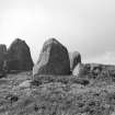
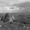
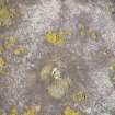
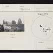
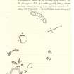
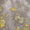
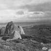
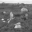
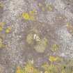
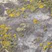
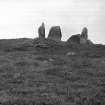
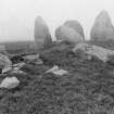
Heights of Brae: An Orkney Cromarty type round cairn, with a polygonal chamber.
The cairn material has been removed, but a slight bank round the remains probably represents its perimeter, giving a diameter of about 75'.
Two chambers are suggested by the visible structural stones which range from 1' to 5' in height. The southern-most has three pairs of slabs suggesting a short passage.
A S Henshall 1963.
"Surrounding the whole are the appearances of several concentric circles of considerable dimensions, but most of the stones have been carried away"
New Statistical Account (NSA) 1845.
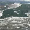
The chamber of this cairn is generally as described by Henshall but only one polygonal chamber is evident. The perimeter of the cairn can be traced as a slight bank, through which several stones protude, surrounding the central chamber at a diameter of c.21.0m.
Re-surveyed at 1/2500. Photo.
Visited by OS (N K B) 1 July 1965
Chambered Cairn (NR) (remains of)
OS 6"map, (1969)
The chambered cairn is as planned by Henshall (A S Henshall 1963). Possibly there are two phases of construction; to the N and NW of the central chamber is a group of four earthfast stones (shown by Henshall) which may be the remains of a structure independent of the main chamber. The perimeter of the cairn can be traced as a slight bank, through which several stones protrude, surrounding the central chamber at a diameter of approximately 21.0m.
Revised at 1/2500.
Visited by OS (J B) 29 November 1976.
No change.
Visited by RCAHMS (JRS) 3 March 1989.
Field Visit (30 August 1943)
This site was included within the RCAHMS Emergency Survey (1942-3), an unpublished rescue project. Site descriptions, organised by county, vary from short notes to lengthy and full descriptions and are available to view online with contemporary sketches and photographs. The original typescripts, manuscripts, notebooks and photographs can also be consulted in the RCAHMS Search Room.
Information from RCAHMS (GFG) 10 December 2014.
Field Visit (September 1978)
Heights of Brae (ROS 22) NH 514 615 NH 56 SW 2
The wasted remains of this Orkney-Cromarty Cairn are situated 350m NNW of Firth View and measure 22m in diameter. There are two chambers visible, the more complete lying to the S of the centre of the cairn and the other to the N.
RCAHMS 1979, September 1978.
Henshall 1963-72, i, 346-7.

