
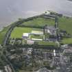
Dingwall Canal, Harbour


Harbour (19th Century)
Site Name Dingwall Canal, Harbour
Classification Harbour (19th Century)
Alternative Name(s) River Peffery; Dingwall Harbour
Canmore ID 218913
Site Number NH55NE 24.03
NGR NH 5615 5844
NGR Description NH c. 5615 5844
Datum OSGB36 - NGR
Permalink http://canmore.org.uk/site/218913


- Council Highland
- Parish Dingwall
- Former Region Highland
- Former District Ross And Cromarty
- Former County Ross And Cromarty
NH55NE 24.03 c. 5615 5844
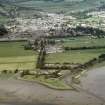
Formerly also entered as NH55NE 26 at cited location NH 561 584.
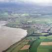
Harbour (disused) [NAT]
OS 1:10,000 map, 1992.
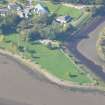
Old harbour frontage subject to some modern bank revetment (stone encased in mesh) and landscaping of Western shore. Wooden timber alignment of posts (c.30cm sq) mooring posts approx 50-60m in length overall.
CFA/MORA Coastal Assessment Survey 1998.
(Location cited as NH 5610 5841). These mooring posts, situated on a spit of land to the S of the harbour, as the canal terminates, are clearly marked on the 1st edition of the OS 6-inch map (Ross-shire 1881, sheet lxxxviii).
Information from RCAHMS (MD) 25 July 2002.

