Pricing Change
New pricing for orders of material from this site will come into place shortly. Charges for supply of digital images, digitisation on demand, prints and licensing will be altered.
Balblair (Duplicate)
Cup Marked Stone (Neolithic) - (Bronze Age), Pictish Symbol Stone (Pictish)
Site Name Balblair (Duplicate)
Classification Cup Marked Stone (Neolithic) - (Bronze Age), Pictish Symbol Stone (Pictish)
Alternative Name(s) Moniack Castle; Wester Balblair; Balblair Stone
Canmore ID 269922
Site Number NH54NW 155
NGR NH 50958 45163
NGR Description NH c. 509 451
Datum OSGB36 - NGR
Permalink http://canmore.org.uk/site/269922
- Council Highland
- Parish Kilmorack
- Former Region Highland
- Former District Inverness
- Former County Inverness-shire
Balblair 1, Kilmorack, Beauly, Inverness-shire, Pictish symbol stone
Measurements: H 1.37m +, W 0.61m
Stone type: diorite
Place of discovery: NH c 493 433
Present location: in the rockery in Moniack Castle garden.
Evidence for discovery: it was recorded by Stuart as having stood near the old parish school at Kilmorack until about 1827, when it was moved closer to the school. Sometime in the later nineteenth century it was taken to Moniack Castle.
Present condition: weathered.
Description
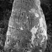
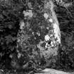
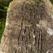
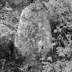
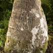
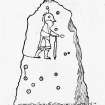
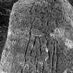
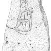
This slab appears originally to have been a prehistoric standing stone with a number of cup-marks carved on it. In Pictish times it was incised with a ‘formidable man’ symbol, seen in profile walking to the right, with a prominent nose and chin. He is wearing a short gored tunic with a band at the hem. Belted at the waist, and he carries a club in his right hand.
Date: seventh century.
References: ECMS pt 3, 95-6; Fraser 2008, no 106.1.
Compiled by A Ritchie 2017
NH54NW 155 c. 509 451 Removed to NH 5518 4357
For present location (NH 5518 4357), see NH54SE 9
Until c.1827 a sculptured stone bearing the incised figure of a man and fourteen cup-marks, stood approximately 100 yards W of the parish school of Kilmorack. When that area of ground was then taken into cultivation, the stone was moved to stand close by the school, and subsequently, between 1867 and 1903, to the rockery of Moniack Castle, where it now stands (NH54SE 9). The school is depicted on the 1st edition of the OS 6-inch map (Inverness-shire sheet 10, 1876) at NH 51061 45167.
J Stuart 1867; J R Allen and J Anderson 1903.
Note (6 February 2020)
Date Fieldwork Started: 06/02/2020
Compiled by: NOSAS
Location Notes: All details recorded under Canmore ID 12732, SCRAP ID 929


