
Dornoch Airfield


Airfield (20th Century)
Site Name Dornoch Airfield
Classification Airfield (20th Century)
Alternative Name(s) Dornoch Landing Strip
Canmore ID 93105
Site Number NH88NW 4
NGR NH 8004 8842
NGR Description Centred NH 8004 8842
Datum OSGB36 - NGR
Permalink http://canmore.org.uk/site/93105


- Council Highland
- Parish Dornoch
- Former Region Highland
- Former District Sutherland
- Former County Sutherland
NH88NW 4 centred 8004 8842
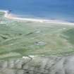
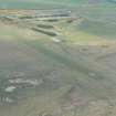
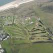
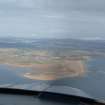
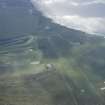
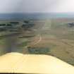
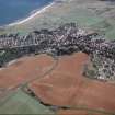
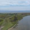
(NH 800 885) Selected as a Satellite Landing Ground it closed during 1945. Re-opening in 1967, services to Inverness and Wick proved uneconomic. Occasionally still used.
D J Smith 1983.
Dornoch airstrip is situated to the S of the town and W of the dunes. Only the airstrip could be seen on the date of visit.
J Guy 2000; NMRS MS 810/10, Vol.2, 109

