
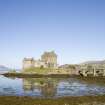
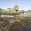
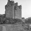
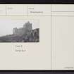
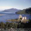
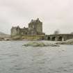
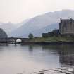
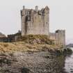
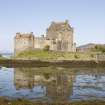
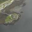
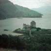
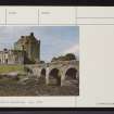
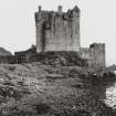
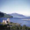
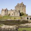
Eilean Donan Castle


Castle (Medieval), Fort (Period Unassigned), War Memorial (20th Century)
Site Name Eilean Donan Castle
Classification Castle (Medieval), Fort (Period Unassigned), War Memorial (20th Century)
Alternative Name(s) Castle Donnan; Ellan Donnan; Loch Duich: Clan Macrae War Memorial
Canmore ID 11823
Site Number NG82NE 3
NGR NG 88127 25836
Datum OSGB36 - NGR
Permalink http://canmore.org.uk/site/11823


First 100 images shown. See the Collections panel (below) for a link to all digital images.
- Council Highland
- Parish Kintail
- Former Region Highland
- Former District Skye And Lochalsh
- Former County Ross And Cromarty
Eilean Donan Castle
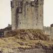
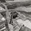
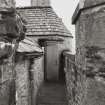
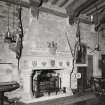
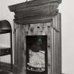
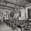
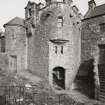
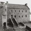
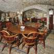
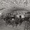
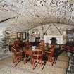
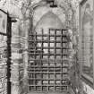
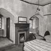
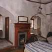
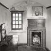
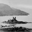
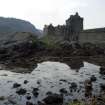
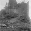
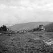
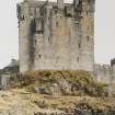
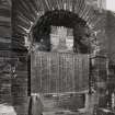
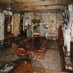
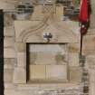
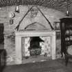
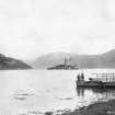
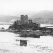
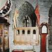
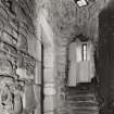
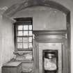
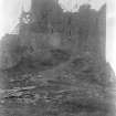
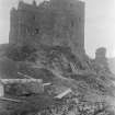
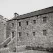
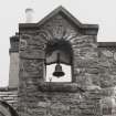
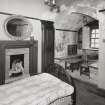
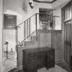
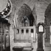
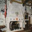
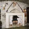
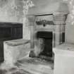
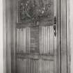
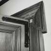
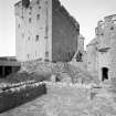
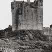
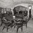
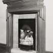
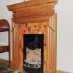
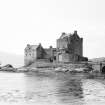
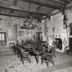
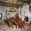
Former stronghold of the Mackenzies of Kintail, destroyed by government fire in 1719 and by 1900 little more than a few fingers of shattered masonry. It was recreated, 1912 -32 , for Maj. John MacRae-Gilstrap by George Mackie Watson and stonemason/carpenter Farquhar MacRae of Auchtertyre, who is said to have forseen the appearance of the rebuilt castle in a dream. The result - now the Macrae Clan Centre - is a romantic reincarnation in the tradition of early 20th-century castle revivals. It follows, more or less, the plan of the earlier castle as it was in its later phases, but uses much Picturesque licence. The main tower is a rebuild of the 14 th century tower house. This was the dominant structure of the tightly composed 15th century defensive enclosure built over part of a much larger 13 th century enceinte (visible now only in fragmentary outline). The castle's appearance in 1714 was recorded in plans and elevations drawn by Lewis Petit for the Board of Ordnance, but was not used as a source in the rebuilding. Only part of the L-plan block was recreated - as an austere crowstep-gabled house - while the south east building was altered and extended. Mackie Watson introduced a much more elaborate version of the 17th-century entrance, and invented machicolations, bartizans, crude gothic-style windows, verandah, a seagate in the west curtain, and a threearched bridge to the mainland. He ignored the plain early 18th century aesthetic, yet omitted decorative mouldings where they were known to have existed. Inside the tower, the style is Edwardian baronial, with oak beamed ceilings, unplastered walls and a canopied 15th-century-style chimneypiece in the first floor banqueting hall. Two of three narrow loops are original. For more information on the Mackenzies and Eilean Donan, see p.194.
[From the late 13th century, the Mackenzies held Eilean Donan as hereditary constables of the Earls of Ross, but by the mid-14th century they had lost control of the castle. Expanding east and westwards over the next two centuries, they re-acquired Eilean Donan in their own right in the later 15th century, receiving a charter for the castle and lands of Kintail in 1509. The castle is strongly associated with their devoted allies, the Macraes - 'Mackenzie's shirt of mail' - who populated this region from the mid-14th century and became hereditary constables under the Mackenzie Earls of Seaforth. The involvement of Eilean Donan in a Jacobite plot of 1719, and its disastrous finale at the Battle of Glenshiel, spelt its downfall. While harbouring a small Spanish garrison, the already damaged castle was bombarded to smithereens by Hanoverian frigates, and remained an uninhabitable ruin until the 20th century.]
Taken from "Western Seaboard: An Illustrated Architectural Guide", by Mary Miers, 2008. Published by the Rutland Press http://www.rias.org.uk

NG82NE 3 88127 25836
See also NG82NE 8.
(NG 8811 2581) Castle Donnan (NR) (Ruins of)
OS 6" map, Ross-shire, 2nd ed., (1905)
This castle is said to have originated as a vitrified fort, the remains of which were visible on the landward side of the island in 1912, in the form of a wall of considerable dimensions (T Wallace 1921) and part of the later castle wall is built over the remains of a shell-heap.
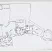
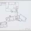
This fort was replaced in the 13th century by a castle consisting of a great wall of enceinte, the outline of which can still be traced. A narrow passage between two walls seems to have formed the entrance from the loch on the west. It was probably originally a steep staircase, but is now only a slope of stones. A keep was erected on the NE angle of the enclosure probably in the 14th century, its N and E walls superimposed on the older wall. The foundation of the tower, 57' x 43', with walls 10' thick, exist all round and fragments of the N and S walls still stand to a considerable height.
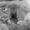
An unusual feature is a heptagonal water tower lying to the east of the castle, but connected to it by walls, about 5' thick and probably originally about 15' high, which enclose a long sloping court.
In 1719 a body of Spanish troops were beseiged in the castle which was battered and ruined by three English men-of-war. It has been restored by Lt-Col MacRae-Gilstrap during the years 1912-1932. (D MacDonald, A Polson and J Brown 1931)
D MacGibbon and T Ross 1889; T Wallace 1921; D MacDonald, A Polson, J Brown 1931.
Castle Donnan, a 13th century keep, formerly ruined and now restored, as described above, built possibly on the site of a vitrified fort. All that remains is some heaped close by the water cistern.
Visited by OS (N K B) 29 September 1966.
Castle Donnan (NR) (restored)
OS 1:10,000 map, (1972)
Castle Donnan is generally as described. A straight length of collapsed walling some 55.0m long lies close to the shoreline on the NW side of the bridge. This is what Wallace refers to as "a wall of considerable dimensions", and loose pieces of vitrification occur amongst the debris. Despite this, however, it may be relatively modern but there is little doubt that a vitrified structure formerly occupied the island.
Visited by OS (A A) 19 June 1974.
ARCHITECT for Restoration: c.1912 - 32 George Mackie Watson
with Farquar MacRae, Carpenter-in-charge
Transcribed from Architecture Catalogue slip:
This Castle has been referred to under the names of Donnan, Donan, and Eileandonan, and latterly by MacGibbon and Ross as Ellandonan. It stands at theWest extremity of the Parish of Kintail, Ross-shire, and Loch Duich. At full tides this Castle, consisting of a Tower and Rampart, and with a built well, became isolated from the Mainland.
According to Statistical Accounts, it was demolished in 1719, after the Battle of Glensheal, by a warship.
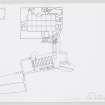
In the National Library of Scotland is a series of Military Maps and Drawings of the Board of Ordnance (Reference MSS.1645-1652), and in Case, or Volume, No.1648 is this Drawing numbered Z.3/26 : -
"Plan of the Castle of Island Dounan", scale 10 Feet to every Inch, with Profile or View. It is indicated as 'Surveyed & deliver'd' by Lewis Petit. There is no date, but there is a copy dated 1741.
It is recorded in the Index Volume No.1652 of the series mentioned above that the Castle of Island Dounan has been restored as a dwelling by Major Macrae Gilstrap, who purchased the ruins.
MacGibbon and Ross, in "The Castellated and Domestic Architecture of Scotland", Vol.111, page 82, give a small Plan and a Sketch in pen and ink. They say that unfortunately its Architectural features were almost entirely destroyed and on the Plan the buildings seem to have been in a ruinous state. The Keep is shewn as a rectangular building some 57 Feet long and some 43 Feet wide, with walls 10 Feet in thickness. What they call an heptagonal Tower 20 Feet in diameter internally and placed at a considerably lower level that the Courtyard of the Castle, they presume to have been a Water Cistern.
REFERENCE:
NATIONAL LIBRARY OF SCOTLAND
MSS 1645 - 52 Military Maps and Plans transferred from Bord of Ordnance
has view of castle and plan by Lewis Petit No.1648
(NMRS has photographic copy & negative of this view and plan)
& sketch by A. Rollo 1949
NMRS LIBRARY
Old Statistical Account, Vol VI. Kintail Parish (1793), page 253
Footnote descibing history of Eilean Donan Castle and how the 'oldest inhabitant of the parish' recollects seeing Kintail 'men under arms', dancing on the leaden roof...setting out for battle of Sherrif-muir...' etc.
Wanderings in the Western Highlands & Islands, Miss M Donaldson (1923), pages193 - 5
Hostile description of Restoration
The NMRS holds copies of Miss Donaldson's prints (negatives in Inverness Museum box 63 No.s 759, 760, 762, 766) which show the early stages of restoration (work which was possibly substantially altered)
'Eilean Donan Castle, Ross-shire'
Antony Woodward
Country Life, 13th January 1994, pages 50 - 53
Incident (1719)
In 1719 a body of Spanish troops were beseiged in the castle which was battered and ruined by three English men-of-war.
Field Visit (29 September 1966)
Castle Donnan, a 13th century keep, formerly ruined and now restored, as described above, built possibly on the site of a vitrified fort. All that remains is some heaped close by the water cistern.
Visited by OS (N K B) 29 September 1966.
Field Visit (19 June 1974)
Castle Donnan is generally as described. A straight length of collapsed walling some 55.0m long lies close to the shoreline on the NW side of the bridge. This is what Wallace refers to as "a wall of considerable dimensions", and loose pieces of vitrification occur amongst the debris. Despite this, however, it may be relatively modern but there is little doubt that a vitrified structure formerly occupied the island.
Visited by OS (A A) 19 June 1974.
Publication Account (1995)
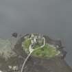
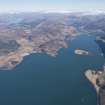
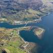
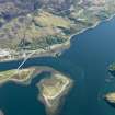
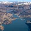
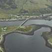
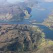
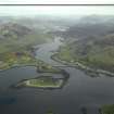
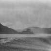
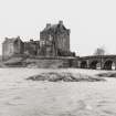
The castle stands in a spectacular setting on a small islet at the junction of Loch Duich, Loch Alsh and Loch Long. Originally accessible only by boat, it is now linked to the shore by a modern bridge. From the old road above the A 87 there are splendid views over the castle to the hills of Skye beyond.
Fragments of vitrified stone found on the shores of the island show that there was once a prehistoric or dark-age fort here. In hi storic times, the site may have been fortified in the 13th century, but the present tower was built in the late 14th century and belonged to the Earls of Ross. It passed to the Mackenzies of Kintail in the early 16th century, when the MacRaes became Constables of the castle.
In 1719 the castle was occupied by a small Spanish garrison, part of a force supporting an unsuccessful Jacobite ris ing on behalf of the Old Pretender, James, the son of King James H. Three English frigates sailed into Loch Alsh and bombarded the castle, which lay in ruins for the next 200 years. It was restored between 1912 and 1932 by a descendant of the MacRaes, so what is seen today is almost entirely modern; though not correct in every detail, it give an excellent idea of the original appearance.
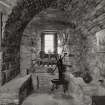
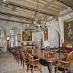
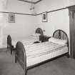
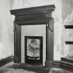
Within the great tower, the stone-vaulted basement would originally have been for storage, reached only by an internal stair from the hall above. The great hall on the first floor had a large canopied fireplace, a wooden ceiling carried on heavy wooden beams, deep window embrasures, and stairs in the thickness of the wall leading to the bedrooms above. The main entrance on this floor would have been reached by an outside wooden stair. Note the two massive wooden bars that secure the door inside and the square bar-holes in the wall that they slide into; brochs had much the same arrangement. In the hall is a fine iron yen, which originally must have reinforced the main entrance door.
The buildings round the tower were reduced to little but the stumps of their walls before restoration, but the hexagonal structure near the bridge is mostly original masonry and appears to have been a large and unusual cistern for storing rain-water.
Information from ‘Exploring Scotland’s Heritage: The Highlands’, (1995).
Archaeological Evaluation (March 2008 - October 2008)
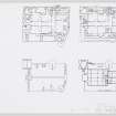
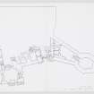
NG 8812 2583 Two phases of investigation were undertaken in 2008. During March, a geophysical and topographical survey was carried out of all accessible parts of the island. The topographical survey provided a detailed and accurate contour plan of the island, and accurately located visible earthworks and exposed stonework. The geophysical survey defined the possible line of the curtain wall, and allowed the design of an evaluation programme.
The evaluation took place, September–October 2008, and consisted clearance of vegetation from the earthwork representing the NW tower and excavation of five trenches. The removal of vegetation exposed the complete outline of the tower. The removal of rubble from half of the interior exposed the lower courses of the elevations and the unshaped bedrock surface inside it (Intervention 3).
Intervention 4 consisted of an 11 x 2m trench immediately S of the tower. This exposed the external elevation and part of the abutting curtain wall. Previous ‘wall-chasing’ had removed the stratigraphic relationship between the deposits and the tower; however, well preserved medieval remains survive in situ, including occupation layers and a metalworking horizon. Finds included a small annular brooch, slag and a quantity of nails.
In the NE part of the island, intervention 5 encountered a mortar-rich dump, likely to relate to 20th-century
reconstruction overlying a 4m wide length of curtain wall. Intervention 6 encountered a poorly preserved wall that appeared to represent the remains of a tower, which had been backfilled with large boulders. Intervention 7 was to the S of the island, and recorded a well preserved, well built length of curtain wall, measuring 5m wide and over 1.3m high. This would have been situated at the high tide mark on the island.
Archive: Post-excavation work is ongoing, and a report will be deposited with RCAHMS
Funder: Conchra Charitable Trust
Field Archaeology Specialists Ltd, 2008
Excavation (September 2009 - October 2009)
NG 8812 2583 An open area excavation was undertaken in September–October 2009, following a programme of evaluation consisting of geophysical and topographic survey and evaluation trenches, undertaken in 2008 (DES 2008, 110). Work focused on the NW tower on the N side of the island and involved the excavation of the interior of the tower and the areas to the immediate E and S.
Excavation inside the tower revealed an irregular bedrock base with deposits of lime mortar against the internal walls. The mortar is thought to derive either from eroding bonding mortar or to represent the remains of a lime mortar floor. Excavation to the E of the tower revealed the remains of two stone walls. The northernmost lay partially within the excavation area, was oriented E–W and appeared to join the tower at its NE corner. This feature may represent an early curtain wall, since to the immediate S a substantial wall was
identified and post-dates the construction of the tower. The wall measured c5m wide and represents the heavily robbed remains of a curtain wall. The area to the S of the tower contained an evaluation trench and results from open area excavation broadly reflected the interpretation of 2008. The presence of two hearths and a large assemblage of smithing hearth bottoms and slag indicating that ironworking was
taking place in this area. The remains of the W curtain wall were also further revealed. Significant medieval finds from the interior of the castle included two copper-alloy dress pins, a dagger or sword chape, an iron arrowhead, a small iron link, possibly from chainmail, and a sherd of Scottish Redware reused as a gaming counter.
Archive: Post-excavation work is ongoing and a report will be deposited with RCAHMS
Funder: Conchra Charitable Trust
Field Archaeology Specialists Ltd
Excavation (February 2010)
NG 8812 2583 A watching brief was carried out in February
2010 during excavations for a new sewer pipe and pumping
station. The majority of the sewer trench did not encounter
archaeological remains. Four archaeological features that
related to the medieval castle were recorded in the area
approaching the modern bridge. A length of substantial
curtain wall foundation was exposed and may have been
associated with two areas of lime mortar surface. A large
spread of demolition material may have represented a
possible former building stance. The pipe trench was diverted
to avoid the in situ remains of the curtain wall.
An open area excavation was undertaken in September
and October 2010, continuing the excavation work of
2009 (DES 2009, 104). Work focused on the NW tower
and associated curtain wall. A further c3m of curtain wall
was revealed to the E of the NW tower. Differences in
construction showed that a thinner, c2.5m wide wall had
been thickened to double its width. An associated buried
soil showed that this had occurred during the late medieval
period. This alteration might be attributed to the second
half of the 15th century, when the castle seems to have
been fortified to withstand bombardment, and remodelled
to accommodate early artillery. A domestic hearth and an
assemblage of pottery and metalwork, including a copperalloy
stick pin, where found in association with the buried
soil. The medieval deposits overlay a possible demolition
layer, which directly sealed bedrock. A single posthole was
found cutting into the bedrock and a further deposit was
partially exposed underlying the thickened curtain wall. An
earth-bonded rubble wall which is thought to post-date the
castle’s main occupation phases was recorded to the N of
the curtain wall.
Report: RCAHMS (intended)
Funder: Conchra Charitable Trust
Note (23 January 2015 - 18 May 2016)
The medieval castle on the small tidal island of Eilean Donan, heavily restored in the early 20th century, may have occupied the site of an earlier fort, though evaluations in 2008 and further excavation in 2009 and 2010 did not encounter any remains of it. A length of collapsed walling on the NW side of the bridge that now connects the island contains fragments of vitrified stone, though the wall itself probably belongs to the more recent defences.
Information from An Atlas of Hillforts of Great Britain and Ireland – 18 May 2016. Atlas of Hillforts SC2744
Excavation (September 2015 - October 2016)
NG 8812 2583 (NG82NE 3) An open area excavation was undertaken at Eilean Donan Castle in September and October 2015 and 2016, continuing the excavation work of 2010. Excavation focused on the NW tower and associated curtain walls to the N and W. A small early internal castle building was defined and excavated adjacent to the NW tower. The building, which measured c3.0 x 2.0m, was furnished with a lime mortar floor and may have had a service function. The building was used for rubbish disposal in its last phase. Subsequently, evidence for a castle smithy was excavated and overlay the earlier building slightly. A working floor rich in hammerscale, a large assemblage of ironworking slags and a large rotary grindstone were recorded in the smithy deposits. Adjacent deposits yielded a significant assemblage of vitrified clay crucible fragments relating to the casting of non-ferrous metals. The smithy and metalworking is thought to date to the 15th century.
Excavation of the W curtain wall established that it had been comparatively modest, only c1.0m wide, and connected to a previously unidentified tower at its southern end, which was manifest as a substantial mortar-bonded masonry building of which only the N corner was visible.
Further exploration of the thickened N curtain wall identified a previously unknown lime kiln and a further possible interval-tower stance. The interval-tower was identified close to the eastern limit of intervention and had suffered from truncation during the restoration phase, but was obvious as lime-mortar bonded blocks projecting from the line of the curtain wall.
The lime kiln cut into the thickened wall and was revealed as a horse-shoe shaped, deep below-ground structure which partially lay beyond the limit of intervention. Excavation identified the remains of the last firing overlain by a closing deposit of animal bone and shellfish thought to derive from household butchery, hunting and fishing waste. The kiln is thought to be 16th-century in date and may have been built to provide mortar for a programme of remodelling and rebuilding.
Inside the N curtain wall a possible building stance was identified through a deposit rich in structural ironwork and artefactual material. Artefacts included coins, arrowheads, part of an iron jew’s harp and an antler hair parter or gravoir, which is believed to be the only example from medieval
Scotland.
Archive: Post-excavation work is ongoing. Report: NRHE (intended)
Funder: Conchra Charitable Trust
Nicola Toop – FAS Heritage
(Source: DES, Volume 18)

