
Skye, Dunvegan, St Mary's Church, Churchyard


Burial Ground (Medieval), Grave Slab(S) (Medieval)
Site Name Skye, Dunvegan, St Mary's Church, Churchyard
Classification Burial Ground (Medieval), Grave Slab(S) (Medieval)
Canmore ID 10799
Site Number NG24NE 1.01
NGR NG 25496 47811
Datum OSGB36 - NGR
Permalink http://canmore.org.uk/site/10799


- Council Highland
- Parish Duirinish
- Former Region Highland
- Former District Skye And Lochalsh
- Former County Inverness-shire
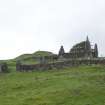
St. Mary's, Kilmuir, 1694. Consolidated rubble oblong of old Duirinish parish church in stone-walled burial enclosure, reminiscent of Skye's other post-Reformation parish churches of Strath and Sleat. Eighteenth century aisle and mural memorials; balustraded burial enclosure with architraved doorway of 1735 attached to west gable. Although St. Clement's Church, Rodel was the principal resting place for the Macleod chiefs, some are buried here, as are generations of MacCrimmons, hereditary pipers to the Macleods. Predominant in the graveyard is an ashlar obelisk memorial, early 18th century, with weathered inscription to 'Lord Thomas Frazer' (father of Simon, 11th Lord Lovat, who was executed on Towerhill in 1747) who died at Dunvegan while visiting his brother-in-law in 1699. In 1888 this 'lay in pieces on the ground', the kirk ruinous, overgrown with weeds and filled with junk, according to J. and E. Pennell. Its roof had caved in about 20 years earlier. Some carved late-medieval gravestones and 18th century tablestones.
Taken from "Western Seaboard: An Illustrated Architectural Guide", by Mary Miers, 2008. Published by the Rutland Press http://www.rias.org.uk

Field Visit (10 May 1915 - 8 September 1922)
Old Parish Church, Dunvegan.
On high ground overlooking the clachan of Dunvegan, at the head of the loch, is the ruin of the old Post-Reformation Parish Church, an in ornate rubble-built structure originally oblong on plan, to which in the 18th century a north burial aisle was added. The voids have freestone dressings, and the lintel of the north door is inscribed IML 1694. The church has been galleried and the west gable is surmounted by the remains of a belfry. A burial enclosure against this gable has a good Renaissance doorway and balustrade dated 1735. The churchyard is still known as Kilmuir, as is also the adjoining township, preserving the ancient dedication, St Mary.
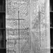
CARVED SLABS. In the kirkyard are three grave slabs with a claymore and foliaceous designs carved on them. The best preserved stone is 6 feet 5 inches long by 20 inches wide at the top, tapering to 16½ inches at the foot. The edge of the stone is chamfered, and about 2 inches from the edge a shallow hollow channel about 1 inch wide is cut round the slab. Within this hollow is a moulding, from which the twigs of the foliaceous design spring towards the interior. In the centre of the panel is a two-handed sword with depressed quillons and fan-shaped pommel divided into five sections, the central digit being prolonged into a spike. On the dexter side of the blade the foliage consists of drooping leaves springing from the border, but on both sides of the hilt and on the sinister side of the blade the leaves have five sharp points like holly. The foliage is not continued to the base of this side, but a portion opposite the point of the sword seems unornamented. (Fig. 247.)
The second slab is more weathered and broken at the foot. It measures 5 feet 7 inches in length and 20½ inches in breadth at the top. Like the previous slab the sides converge slightly towards the foot. Within a panel bordered by a flat raised moulding is a claymore with depressed quillons and fan-shaped pointed pommel. The ornamentation on the dexter side is obliterated, but on the sinister side halfway between the sword and the edge of the panel is a straight moulding with lozenges at regular intervals, the lozenges terminating in a knob at the outer and inner points. On either· side of this design is an arrangement of leaves almost obliterated.
The third slab is 6 feet 4 inches long, 21. inches broad at the top and 16½ inches at the foot. The design is almost worn off, but part of the blade of the claymore is discernible.
There is a number of interesting "throuch" stones in the graveyard dating from the end of the 17th and beginning of 18th centuries.
COMMUNION CUPS. Two handsome communion cups of English manufacture, with the hall mark of 1612-13, and bearing the letters SRM over the Macleod arms, have been fully described in the Proc. Soc. Ant. Scot., Vol. XX., pp. 398-446.
RCAHMS 1928, visited 10 May 1915 and 8 Sept. 1922.
OS map: Skye xxi.
Field Visit (18 November 2019 - 19 November 2019)
NG 25219 50480 (N area centred) and NG 25344 47923 (S area centred) A desk-based assessment and walkover survey were conducted at Totachocaire Farm, near Dunvegan, Isle of Skye. The survey area included a northern area around Totachocaire and Glen Suardal, and a southern area around Druim na Creige and St Mary’s church on the N side of Dunvegan village. The survey was required in advance of a woodland planting scheme.
The walkover survey was undertaken on 18–19 November 2019, with a total of 65 archaeological sites identified. Sites comprised two prehistoric hut circles (Canmore ID: 10931) as well as numerous medieval and post-medieval farmsteads (Canmore ID: 114771, 114768, 114772), shielings (Canmore ID: 114769, 114773), enclosures (Canmore ID: 305913), dykes and rig and furrow cultivation remains. Mitigation measures are recommended to safeguard the sites during woodland planting.
Archive: NRHE
Funder: Scottish Woodlands
Lindsey Stirling – AOC Archaeology Group
(Source: DES Vol 21)

