
Canna, Beinn Tighe


Mound (Period Unassigned), Souterrain(S) (Prehistoric), Unidentified Pottery
Site Name Canna, Beinn Tighe
Classification Mound (Period Unassigned), Souterrain(S) (Prehistoric), Unidentified Pottery
Alternative Name(s) Earnagream
Canmore ID 10726
Site Number NG20NW 2
NGR NG 2444 0625
Datum OSGB36 - NGR
Permalink http://canmore.org.uk/site/10726


- Council Highland
- Parish Small Isles
- Former Region Highland
- Former District Lochaber
- Former County Inverness-shire
NG20NW 2 2444 0625.
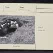
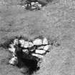
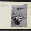
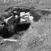
Two small earth-houses are situated on the S slope of Beinn Tighe, just below the summit of a grassy knoll facing SE. Others probably remain unexposed nearby; the two that have been opened have been driven into the hillside, one below the other, and 20ft apart. Each has an entrance c.18" broad, opening into a lintelled space 5ft broad in one house and 3ft in the other, in which are further lintelled recesses.
Lethbridge notes 'traces of a house on top of an earth-house' and states that unornamented potsherds etc have been found. (Private 6"map annotated by T C Lethbridge 1953)
RCAHMS 1928.
At NG 2444 0625 built into the S face of a grassy rise are two crudely built souterrains. The lower one is an irregularly-shaped lintelled chamber measuring 3.0m N-S by 1.5m transversely. The other, about 4.0m higher up the slope, is of similar construction but slightly smaller. There is no trace of 'lintelled recesses' inside as stated by the RCAHMS. There are no traces of a house or of other souterrains in the vicinity, nor is there any local knowledge of potsherds found at the site.
Surveyed at 1/10,560.
Visited by OS (I S S) 31 May 1972.
The crude construction of these souterrains and the lack of a passage would seem to indicate a later date than IA.
Visited by OS (A A) 2 June 1972.
Field Visit (6 July 1925)
Earth-houses.
On the southern slope of Beinn Tighe, just below the summit of a grassy knoll facing south-east, are two small earth-houses, and others probably remain unexposed near by. The two that have been opened have been driven into the hillside, one below the other at a distance of 20 feet apart. In each there is a narrow entrance about 18 inches broad opening in a lintelled space, 5 feet broad in one house, 3 feet in the other, in which are lintelled recesses just large enough for a person to squat in. These earth houses are smaller and much less intricate than any met with in the outer isles.
RCAHMS 1928, visited 6 July 1925.
OS map: Island of Canna (Inverness-shire) liii and liv (unnoted).
Field Visit (4 May 1994)
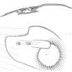
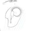
A substantial grass-grown mound may be all that now survives of a structure associated with the souterrain previously recorded on the S flank of this low rise immediately to the SW. The mound, which lies on the crest of the rise on the E side of an old field-wall measures about 15m in diameter; it has been damaged by rabbit burrowing, and on the date of visit ; three sherds of pottery were recovered from the upcast from a rabbit scrape. The souterrain is aligned from N to S and survives in two sections, modern breaks provide access through the roof. The upper section measures 6m in length, and the lower 3.8m. These two sections have previously been interpreted as two separate souterrains, but it is clear from the survey that they belong to the same structure. Internally, the souterrain varies between 0.8m and 1.3m in breadth, and appears to narrow as the floor rises northwards towards the mound. Its sides are rock-cut, but in places stretches of stone walling survive, and the stone lintels of the roof are partly supported on at least three pairs of opposing stone piers set against the sides of the passage. On the surface, the course of the souterrain to the N is indicated by a U-shaped hollow in the SW side of the mound, but some of the disturbance around the souterrain is probably the spread of upcast material created when the trench for the passage was originally dug out.
(Canna 157-8)
Visited by RCAHMS (IMS, ARG), 4 May 1994
Measured Survey (9 March 1996 - 10 March 1996)
RCAHMS surveyed the souterrain and mound at Beinn Tighe (Earnagream), Canna between 9-10 March 1996 with plane-table and alidade at a scale of 1:100. The plan and section were redrawn in ink and published as part of the Canna Broadsheeet (RCAHMS 1999). The plan was also used as the basis for an illustration that was published in 2016 (Hunter, fig. 2.13).
Artefact Recovery (26 January 2011)
Artefacts were picked up from rabbit burrows on the south and east sides of the mound and included nine sherds of coarse pottery, a small piece of slag, a flint flake, two fragments of burnt bone and two pieces of fire-cracked pebble. The pottery included a plain inverted rim sherd.
Visited by NTS (DA 26/1/2011)
Project (16 April 2015 - 23 April 2015)
As part of on-going work by the National Trust for Scotland four sites on Canna were investigated, 16–23 April 2015, using a variety of geophysical techniques. NG 2444 0625 Beinn Tighe Souterrain A substantial grass mound encompasses a souterrain on its S flank. The mound, which lies on the crest of a rise on the E side of an old field wall, is c15m in diameter and has been extensively damaged by rabbit burrowing. The souterrain is aligned N/S
and survives in at least two sections with modern breaks providing access through the roof. The upper section is 6m long and the lower 3.8m. Internally, the souterrain varies between 0.8–1.3m in width. Its sides are rock-cut, but in places stretches of stone walling survive. The rabbit burrowing has previously uncovered many fragments of coarse pottery, but also some slag, flint, and bone. Ground Penetrating Radar (GPR) and resistance survey was carried out over the souterrain to confirm its full extent and to map any potential structures associated with it.
Although a wealth of anomalies was detected by the GPR survey, interpretation is cautious. Several coherent responses are evident within the data, but whether these are due to potentially significant in situ structures or rabbit burrows is not clear. The situation is further complicated by the fact that rabbit burrows could be utilising any possible structural remains, as was observed with the ‘walling’ of the souterrain. The resistance survey showed well defined high resistance anomalies which suggest buried stone, a more definitive interpretation is limited by the later ridge and furrow cultivation and, again, by the extensive rabbit burrows. NG 2441 0593 Beinn Tighe Neolithic Site The known Neolithic site in Beinn Tighe is a low mound, which is
overridden by lazy bed cultivation. The terrace forms part of the floor of a rocky amphitheatre, and the mound lies towards its leading edge. As an assemblage of Neolithic pottery and flint flakes had been recovered as a result of rabbit damage to the mound, the site was excavated in 2006–7 as part of a programme to assess the nature and extent of rabbit damage to archaeological structures. Two trenches were excavated across the site and produced quantities of pot sherds and some lithics. Well-stratified charcoal from the lower archaeological layer was also recovered. To better understand the extent and nature of the site a resistance survey was undertaken.
Although well defined high resistance anomalies were detected, which suggest the presence of buried stone beneath the surface, a more definitive interpretation is limited by the later ridge and furrow cultivation and the extensive rabbit burrows within the area. However, the resistance data shows good correlation with the previous excavation and test pitting results suggesting the limits of the resistance anomalies are archaeologically significant rather than simply the product of later agricultural activity.
NG 2692 0553 A’ Chill, St Columba’s Chapel A’ Chill is reputedly a monastic site established by St Columba, or possibly a monastery established at the site of a Columban chapel. Nothing is now visible of the chapel and burial ground which once stood at A’ Chill although the site is marked by a finely carved Celtic Cross. Until about 1850 this was also the principal area of farming settlement on the island. The area was cleared of tenants in 1851 and little trace of the township can now be seen. The resistance survey was undertaken over a c1ha area and detected a wealth of anomalies of likely archaeological significance. The presumed chapel previously detected and evaluated by Bradford University has been detected in this survey, although it is not very well defined. However, this data set suggests possible internal and external responses associated with the main structure suggesting the potential
for a more substantial complex. One of the clearest anomalies within this data set is a rectilinear anomaly to the N of the postulated chapel and on the same alignment. Anomalies apparently associated with the outcropping rock and suggestive of the remnants of structures ‘built in’ to the outcrops have also been detected. Numerous additional linear and rectilinear anomalies have been detected throughout the survey area suggesting a potential network of field systems. In addition, anomalies thought to be associated with the culvert have also been noted. The data set is extremely complex, and it has to be remembered that geophysics cannot date features and it is possible that some apparently associated anomalies are not contemporary and the data is detecting a palimpsest of potential archaeological remains. In addition rabbit activity in the area may be creating spurious anomalies.
NG 278 056 Coroghon Township The British Fisheries map of Canna Harbour of 1788 shows nine houses above Coroghon Bay in a valley called Lag a’ Bhaile (the dell of the township) in the E of the island. The township is also shown in a sketch, probably drawn from memory by Lt Peirce in 1787. However, by the time of the Clanranald map of 1805 there is no sign of the township. It was decided in consultation with the National Trust for Scotland to undertake a limited survey of the field. Unfortunately the resistance survey failed to identify any anomalies of archaeological significance. Time permitted only limited survey in this area and it is possible the survey did not cover the area of the former township. The survey was positioned based on the 1787 sketch and it is possible, based on British Fisheries map that the survey block was too far to the E. However, it is also possible that no buried remains associated with the township survive either due to the nature of construction within the township, or because subsequent intensive ploughing has destroyed any ephemeral deposits. It is also feasible that any potential surviving remains are buried under colluvium beyond the depth resolution of the technique.
Archive: Rose Geophysical Consultants
Funder: The National Trust for Scotland
Susan Ovenden - Rose Geophysical Consultants
(Source: DES, Volume 16)
Resistivity (16 April 2015 - 23 April 2015)
NG 2444 0625
NG 2441 0593
NG 2692 0553
NG 278 056
As part of on-going work by the National Trust for Scotland, resistance surveys took place at four sites on Canna.
Archive: Rose Geophysical Consultants
Funder: The National Trust for Scotland
Susan Ovenden - Rose Geophysical Consultants
(Source: DES, Volume 16)
Ground Penetrating Radar (16 April 2015 - 23 April 2015)
NG 2444 0625 Beinn Tighe Souterrain
As part of on-going work by the National Trust for Scotland, a Ground Penetrating Radar survey was carried out over the souterrain to confirm its full extent and to map any potential structures associated with it.
Archive: Rose Geophysical Consultants
Funder: The National Trust for Scotland
Susan Ovenden - Rose Geophysical Consultants
(Source: DES, Volume 16)

