
Canna, A' Chill


Township (Period Unassigned)
Site Name Canna, A' Chill
Classification Township (Period Unassigned)
Alternative Name(s) Keill
Canmore ID 137739
Site Number NG20NE 45
NGR NG 2695 0560
Datum OSGB36 - NGR
Permalink http://canmore.org.uk/site/137739


- Council Highland
- Parish Small Isles
- Former Region Highland
- Former District Lochaber
- Former County Inverness-shire
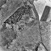
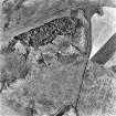
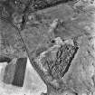
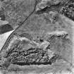
Keill (A Chill) Site of an Early Christian monastic foundation, a medieval parish church (ruinous by late 18th century) and, until the 19th century, Canna's principal settlement. The natural amphitheatre has yielded a significant group of early Christian carved and incised stone slabs, some now removed to Canna House for safekeeping. Outstanding among these is a richly ornamented 8/9th century cross, now with its upper and south arms broken off. It depicts the Adoration of the Magi and animals.
Taken from "Western Seaboard: An Illustrated Architectural Guide", by Mary Miers, 2008. Published by the Rutland Press http://www.rias.org.uk

NG20NE 45 2695 0560
The buildings and enclosures that formed the township of Keill (A' Chill) are shown on an estate map of 1805. This was the main township on the island, and was centred on the ruins of St Columba's chapel and a free-standing sculptured cross (NG20NE 1 and NG20NE 2 respectively). The area was cleared of tenants in 1851 and no trace of the township can now be seen, although a small enclosure (NG20NE 37) is situated between two rock outcrops 40m to the S of the cross.
Visited by RCAHMS (ARG), 20 August 1996.
J L Campbell 1984.

