
Harris, Rodel


Military Camp (20th Century)
Site Name Harris, Rodel
Classification Military Camp (20th Century)
Alternative Name(s) Rodel Hotel
Canmore ID 214749
Site Number NG08SW 17
NGR NG 04679 83043
NGR Description Centred on NG 04679 83043
Datum OSGB36 - NGR
Permalink http://canmore.org.uk/site/214749


- Council Western Isles
- Parish Harris
- Former Region Western Isles Islands Area
- Former District Western Isles
- Former County Inverness-shire
NG08SW 17 centred on 04679 83043
For Radar Station see NG08SE 3
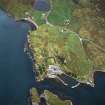
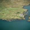
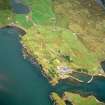
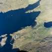
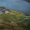
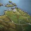
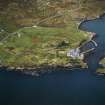
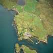
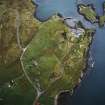
This accommodation camp for the personnel of the Radar Station (NG08SE) is situated to the SW of St Clement's Church (NG08SW 7) on the W side of the A859 road.
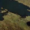
There are many hut bases still extant, a water tank and two air-raid shelters were also noted on the date of visit.
J Guy 2002; NMRS MS 810/12, 119-120, 123-4
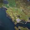
The hutted camp is visible on vertical air photographs taken in 1946 (106G/Scot/UK 104, 4180-4182, flown 19 May 1946), in an area immediately N of the walled garden of the Rodel Hotel (NG08SW 11).
At least sixteen mainly Nissen type huts are visible, including a group of four conjoined huts forming a t-shape in plan and what is possibly an electricity generating house at NG 04672 83100. Only one hut base can be seen on the photographs.
The hut bases are depicted on the current OS 1:2500 scale digital map.
Information from RCAHMS (DE), August 2005

