
North Uist, Coileagan An Udal


Settlement (Neolithic) - (Medieval), Wheelhouse(S) (Iron Age)
Site Name North Uist, Coileagan An Udal
Classification Settlement (Neolithic) - (Medieval), Wheelhouse(S) (Iron Age)
Alternative Name(s) The Udal; Rubha An Udail; Grenetote; Sollas
Canmore ID 10330
Site Number NF87NW 2
NGR NF 8253 7834
Datum OSGB36 - NGR
Permalink http://canmore.org.uk/site/10330


- Council Western Isles
- Parish North Uist
- Former Region Western Isles Islands Area
- Former District Western Isles
- Former County Inverness-shire
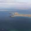
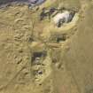
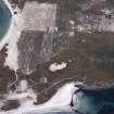
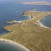
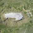
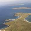
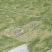
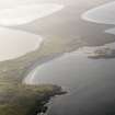
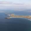
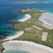
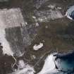
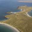
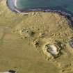
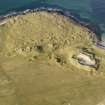
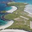
The Udal. Situated on the sandy wing of Machair Leathann north of Sollas, this important site, excavated from the early 1960s, bears evidence of continuous occupation from Neolithic times to the post-medieval period.
Taken from "Western Seaboard: An Illustrated Architectural Guide", by Mary Miers, 2008. Published by the Rutland Press http://www.rias.org.uk

NF87NW 2 825 783.
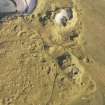
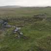
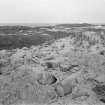
NF 824 784 An extensive domestic settlement containing the elements of at least 20 buildings was partly excavated at Udal in 1963 and 1964. Widespread oral tradition a century ago suggested that the site was anciently called Veilish and that the name can be equated with varied name forms appearing regularly in the charters of the Great Seal between 1465 and 1660. The traditions further suggest that Veilish, ie. Udal, was the main settlement in the Northern Isles in the 13th and 14th centuries.
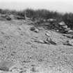
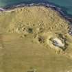
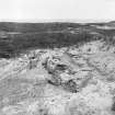
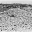
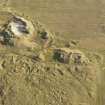
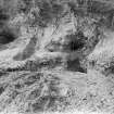
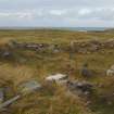
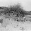
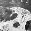
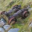
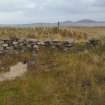
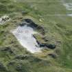
The site lies among four large sand dunes, some 40ft high, on the slopes of which the RCAHMS, in 1914, noted kitchen midden refuse and quantities of stones, apparently the ruins of earth houses. This description, with the exception of the term 'earth houses', is still appropriate. Elaborate iron work and decorated pottery, both undatable, and a considerable quantity of iron slag, suggesting mediaeval iron-working, were found during excavations.
The excavations in the main area exposed two buildings in toto. The later building, incorporating fabric and materials of the other, may be a chapel site but could have been an 18th century kelp-burners' bothan. The other building, an ovoid building of massive construction, with double infilled walls - 6ft thick, seems likely to be the first domestic building dating from the period 1000 - 1600 AD yet discovered in the West Highlands, and may well be a mediaeval prototype of the 'black house'.
Surface finds made before 1921 are in the National Museum of Antiquities of Scotland (NMAS).
I A Crawford 1964; RCAHMS 1928; Proc Soc Antiq Scot 1912; 1915; 1916; 1922.
NF 825 783 Udal settlement is as described above. Excavation was in progress during 1965.
Visited by OS (R D) 23 June 1965.
Additional information - Fort.
I A Crawford 1966.
Field Visit (17 August 1914)
Earth-houses (ruined), Udal.
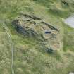
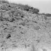
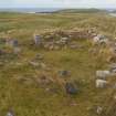
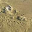
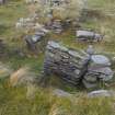
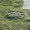
Amongst the sand dunes on the western side of the peninsula extending north-east from Sollas, at Udal about 2 ½ miles north of Sollas, are four large sand dunes, the slopes of which are covered with kitchen midden refuse, consisting of shells, animal bones and fragments of hand-made pottery. At different places on the slopes are quantities of stones, dislodged by wind denudation, apparently the ruins of earth-houses. On the north-western slope of the most northerly mound the only building traceable is a curved section of the foundation of a wall with two other walls running inwards some 6 feet towards the centre, forming the outer part of a chamber 9 feet wide at the exterior end and narrowing towards the interior. About 30 feet to the east there is a considerable quantity of iron slag amongst the fallen stones. On the south side of the mound a length of 8 feet of a curved wall is exposed, and near this were found a piece of flint and part of an axe of red sandstone used as a hammer stone, with slight parallel grooves on one side, apparently made by sharpening pins. Other relics on Fig. 149.
About 40 yards to the south is the second mound at the west side, where amongst fallen stones the curve of a wall measuring 24 feet across the chord, apparently with a curved entrance passage 2 feet 4 inches wide and traceable for some 6 feet, is visible.
The third mound lies about 50 yards southwest of the last, and shows a large quantity of fallen stones on the western slope. To the north-west a section of curved walling 6 feetlong and 3 feet high, with a short length of a radial wall running into the sandhill, is noticeable. To the south of this on the western side the earth-house partly excavated some years ago still remains in view. Though much of the building has fallen, the S-shaped entrance and part of the wall on either side of its inner end can be traced. On the south side of the hill is the southern arc of a curved wall showing a diameter of 38 feet.
On the fourth and most westerly hill the southern slope shows many displaced stones, the only part in position being on the southwest, where a small portion of a curved wall is visible. Some of the kitchen midden deposits measure up to 1 foot in thickness and are evidently of later date than the earth-houses, as in places they overlap the buildings.
RCAHMS 1928, visited 17 August 1914.
North Uist xxx (unnoted).
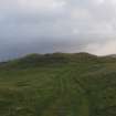
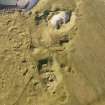
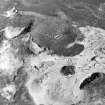
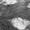
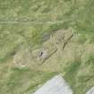
Aerial Photography (May 1966)
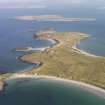
Oblique aerial photographs of Coileagan An Udal settlement, North Uist taken by John Dewar in May 1966.
Publication Account (2007)
NF87 6 THE UDAL (‘Coileagean an Udail’)
NF/824783
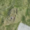
These are four aisled wheelhouses, probably dug-out, in North Uist [7, 232-3]. They appear to have been built into a slope and therefore to have been partly dug-out and partly free-standing. The site at Udal is one of the most remarkable in north-west Europe and consists of several mounds containing structure and occupation layers spanning the last three or four millennia. It was excavated for many years in the 1960s, 1970s and 1980s by Iain Crawford but full details of the discoveries are not available yet, and several interim reports have to be relied on.
Judging from the small scale plan available [7, 122] three of the wheelhouses at Udal form a fairly tight cluster, like Foshigarry (NF77 6). Some further architectural details can be gleaned from Crawford’s comments and table [7]. Four C-14 dates are listed in his table of dates [7, Table 15] and they all fall into the first and second centuries AD. A piece of 3rd century Roman pot in a late wheelhouse context was also found [7, Table 17].
Sources: 1. NMRS site no. NF 87 NW 1 and 2: 2. RCAHMS 1928, 273, no. 89: 3. Crawford 1965: 4. Crawford 1966: 5. Discovery and Excavation in Scotland, 1966, 29: 6. Armit 1992, 51-2: 7. Crawford 2002.
E W MacKie 2007

