
South Uist, Gro Ghot


Cairn (Bronze Age), Shieling Hut (Post Medieval), Spring (Period Unknown)
Site Name South Uist, Gro Ghot
Classification Cairn (Bronze Age), Shieling Hut (Post Medieval), Spring (Period Unknown)
Canmore ID 10143
Site Number NF83SE 1
NGR NF 85795 34365
Datum OSGB36 - NGR
Permalink http://canmore.org.uk/site/10143


- Council Western Isles
- Parish South Uist
- Former Region Western Isles Islands Area
- Former District Western Isles
- Former County Inverness-shire
NF83SE 1 8579 3436.
(NF 8579 3436) Gro Got (Site of) (NAT) Dun (NR)
OS 6"map, Inverness-shire, 2nd ed., (1904)
An irregular mound of stones, about 30ft in diameter, with the ruins of an old house in the centre, is situated at a place called Gro Ghot. In 1915 there were insufficient remains to indicate that it was originally a defensive structure.
RCAHMS 1928.
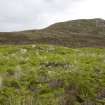
Above confirmed. The rubble mound, 1.5m high, lies in a poordefensive position at the foot of a steep slope and in a slight hollow. There are little or no 'dun like' characteristics, the feature resembling a cairn rather than a dun.
Surveyed at 1:10560.
There is a small rubble-walled shieling structure about 15.0m SW of the mound.
Visited by OS (J T T) 14 May 1965.
Field Visit (15 June 1915)
418. Dun (site of), Gro Ghot, Usinish.
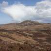
On the hillside about 600 yards south-west of the summit of Beinn Ghot, on the Usinish peninsula, on the eastern shore of South Uist, at a place named Gro Ghot, at an elevation of about 150 feet above sea-level, is an irregular mound of stones about 30 feet in diameter, with the ruins of an old house in the centre. This is marked as the site of a dun on the OS map (South Uist li), but no building can now be detected to indicate that it was originally a defensive structure.
Visited by RCAHMS (JGC) 15 June 1915
Desk Based Assessment (12 February 1965)
(NF 8579 3436) Gro Got (Site of) (NAT) Dun (NR)
OS 6"map, Inverness-shire, 2nd ed., (1904)
An irregular mound of stones, about 30ft in diameter, with the ruins of an old house in the centre, is situated at a place called Gro Ghot. In 1915 there were insufficient remains to indicate that it was originally a defensive structure.
Information from OS (MSG) 12 February 1965
RCAHMS 1928.
Field Visit (14 May 1965)
Above confirmed. The rubble mound, 1.5m high, lies in a poor defensive position at the foot of a steep slope and in a slight hollow. There are little or no 'dun like' characteristics, the feature resembling a cairn rather than a dun.
Surveyed at 1:10560.
There is a small rubble-walled shieling structure about 15.0m SW of the mound.
Visited by OS (J T T) 14 May 1965.
Field Visit (23 April 2013)
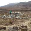
This burial cairn measures 11m in diameter and stands up to 1.5m in height. A later hut has been set into the centre of the cairn. Rectangular in plan, it measures 6m from NE-SW by 4.5m transversely over drystone walls up to 1.2m in height and spread to a thickness of 1m. What may be the remains of another hut stand on the S edge of the cairn.
The shieling hut noted by OS (JTT) in 1965, 15m to the SW of the cairn, appears to be edge-set stones surrounding and protecting a natural spring.
Visited by RCAHMS (AGCH) and Historic Scotland (CB) 23 April 2013

