
North Uist, Tigharry, St Clement's Chapel


Building(S) (Medieval), Burial Ground (Medieval), Chapel (Medieval), Font (Medieval)(Possible)
Site Name North Uist, Tigharry, St Clement's Chapel
Classification Building(S) (Medieval), Burial Ground (Medieval), Chapel (Medieval), Font (Medieval)(Possible)
Canmore ID 10102
Site Number NF77SW 11
NGR NF 71142 72802
Datum OSGB36 - NGR
Permalink http://canmore.org.uk/site/10102


- Council Western Isles
- Parish North Uist
- Former Region Western Isles Islands Area
- Former District Western Isles
- Former County Inverness-shire
NF77SW 11 7114 7279
(NF 7114 7279) St Clement's Chapel (NR) (Site of)
Burial Ground (Disused) (NAT)
OS 6" map, Inverness-shire, 2nd ed., (1904)
St Clement's Chapel is shown on Blaeu's map in 1654 as Kilchalma, and referred to in Origines as Kilchalman, names which would suggest a commemoration of St Colman. In the centre of the graveyard are fragmentary remains of the chapel, a building c. 26ft by 18ft with walls c. 2ft high.
Orig Paroch Scot 1854; E Beveridge 1911.
The remains of St Clement's Chapel, a rectangular building 3.8m by 2.6m within walls 1.3m thick, are reduced to rubble banks 0.3m high.
The burial ground, devoid of gravestones or mounds, is sub-rectangular, c. 26.0m by 21.0m, bounded by a turf-covered wall, 0.5m high and 1.7m thick, incorporating natural outcrop along its NE side. There is the vague outline of a rectangular structure, 3.0m by 5.0m, central against the NW wall of the burial ground and within the enclosure.
The dedication of the chapel could not be confirmed but it is known locally as St Clement's.
Surveyed at 1/2500.
Visited by OS (J T T), 15 June 1965.
Field Visit (16 August 1915)
St Clement's Chapel, Tighary
At the head of a small bay on the western coast of North Uist, about 400 yards south of Manish Point, and about ½ mile north-north-west of Tighary, within a small, disused kirkyard surrounded by the remains of a stone dyke, the foundations of St Clement's Chapel are still discernible. The building has been oblong, lying almost east and west, and measuring about 14 feet 6 inches in length and about 10 feet 9 inches in breadth internally. The door has been in the western gable. Within the building is a quarter portion of a hollowed stone, possibly an old font. The deep cavity is more conical and narrow at the bottom than that of the usual knocking stone; it tapers downwards from 7 inches at top to 2 inches.
On Blaeu's map (1654) this church is Kilchalma and in Orig. Paroch. Kilchalman . These forms suggest a dedication to Colman , who has been confused with Clement.
RCAHMS 1928, visited 16 August 1915.
OS map: North Uist xxxiii.
Field Visit (16 June 1965)
The remains of St Clement's Chapel, a rectangular building 3.8m by 2.6m within walls 1.3m thick, are reduced to rubble banks 0.3m high.
The burial ground, devoid of gravestones or mounds, is sub-rectangular, c. 26.0m by 21.0m, bounded by a turf-covered wall, 0.5m high and 1.7m thick, incorporating natural outcrop along its NE side. There is the vague outline of a rectangular structure, 3.0m by 5.0m, central against the NW wall of the burial ground and within the enclosure.
The dedication of the chapel could not be confirmed but it is known locally as St Clement's.
Surveyed at 1/2500.
Visited by OS (J T T), 15 June 1965.
Desk Based Assessment (1965)
(NF 7114 7279) St Clement's Chapel (NR) (Site of)
Burial Ground (Disused) (NAT)
OS 6" map, Inverness-shire, 2nd ed., (1904)
St Clement's Chapel is shown on Blaeu's map in 1654 as Kilchalma, and referred to in Origines as Kilchalman, names which would suggest a commemoration of St Colman. In the centre of the graveyard are fragmentary remains of the chapel, a building c. 26ft by 18ft with walls c. 2ft high.
Orig Paroch Scot 1854; E Beveridge 1911.
Field Visit (29 May 2012)
This site is largely as described by previous authorities, but the grass-grown rubble walls of the chapel stand up to 0.7m high. The poorly defined building abutting the inside face of the NW side of the enclosure measures 7.5m from NE to SW by 5m transversely over grass-grown rubble-walls standing up to 0.3m high. It appears to have had a central entrance leading out to the NW. There are also faint traces of a third building within the enclosure, situated adjacent to the SE wall. In addition, a low bank runs SW from the W corner of the chapel to abut against the enclosure wall. Half buried in the grass midway along the SW wall of the enclosure and offset 2m to its SW is a stone with a pronounced hollow, which may be the fragment of the font earlier identified by RCAHMS.
Visited by RCAHMS (JRS, ATW) 29 May 2012.
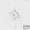
Measured Survey (12 September 2012)
RCAHMS surveyed St Clement's Chapel, North Uist on 12 September 2012 with plane-table and alidade producing a plan at a scale of 1:250.

