
Benbecula, Dun Torcusay


Galleried Dun (Prehistoric)
Site Name Benbecula, Dun Torcusay
Classification Galleried Dun (Prehistoric)
Canmore ID 9973
Site Number NF75SE 5
NGR NF 7618 5313
Datum OSGB36 - NGR
Permalink http://canmore.org.uk/site/9973


- Council Western Isles
- Parish South Uist
- Former Region Western Isles Islands Area
- Former District Western Isles
- Former County Inverness-shire
NF75SE 5 7618 5313.
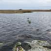
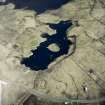
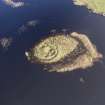
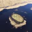
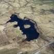
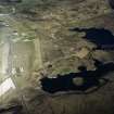
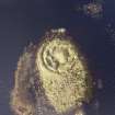
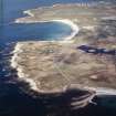
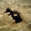
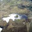
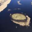
(NF 7618 5313) Dun Torcusay, which has been robbed of stone to build houses 300 yards north-east at Nunton, is situated on an islet in Loch Torcusay, Benbecula. Only the foundations remain of an irregular oval building which is 40ft north-south and 32ft across internally. The ends of an entrance on the south overlap to face west. There is another entrance at the north-east, to the south of which is a possible chamber 17ft long north-south by 5 1/2ft wide.
RCAHMS 1928.
Dun Torcusay is a galleried dun. The entrance is 1.2m wide and is checked for a door. Immediately to the S of the entrance, is a large rectangular chamber; and further round the wall in the north and south are two other smaller chambers. The walls, which are constructed of roughly faced stones, are 1.1m high.
There is no trace of the overlapping entrance in the south mentioned by RCAHMS.
Surveyed at 1:2500.
Visited by OS (R D) 18 May 1965.
Field Visit (14 July 1915)
Dun Torcusay, Loch Torcusay, Nunton.
Some 300 yards south-west of Nunton is a small loch known as Loch Torcusay, near the middle of which is an islet entirely covered and surrounded by a rank growth of reeds. The greater part of its area has been occupied by Dun Torcusay, which has been despoiled of stones to build houses at Nunton. Only the foundations are left, and these are difficult to trace amongst the vegetation. The building is an irregular oval measuring internally some 40 feet from north to south, and 32 feet across, the wall standing about 2 feet in height at most, and measuring some 2 to 3 feet in thickness; in the centre is a mound 4 feet in height. On the south there is a break in the wall, the ends of which overlap to form an entrance from the west, some 4 feet 6 inches wide. There is also another entrance from the north-east, 4 feet 6 inches wide, to the south of which within the enceinte there seems to be a chamber measuring about 17 feet in length from north to south and 5 feet 6 inches wide at the northern end.
RCAHMS 1928, visited 14 July 1915.
OS map: South Uist xlvi (unnoted).
Publication Account (2007)
NF75 4 DUN TORCUSAY
NF/7618 5313
This probable oval ground-galler-ied or transitional broch (or 'galleried dun') in Benbecula stands on an islet in Loch Torcusay and has been robbed of stones to build nearby houses [1]. The plan of the building seems to be an irregular oval and the wall stands 1.1m high in places but only the foundations remain. The entrance is visible on the east and its door-checks are visible. Immediately to the south of the passage is a large rectangular chamber with traces of two smaller chambers in other parts of the wall. In 1965 [1] no trace was seen of the “second entrance” in the south reported earlier [2].
Sources: 1. NMRS site no. NF 75 SE 5 (with plan): 2. RCAHMS 1928, 101, no. 347.
E W MacKie 2007

