
South Uist, Howmore, Old Churches And Chapels


Chapel(S) (Medieval), Church(S) (Medieval)
Site Name South Uist, Howmore, Old Churches And Chapels
Classification Chapel(S) (Medieval), Church(S) (Medieval)
Canmore ID 9869
Site Number NF73NE 1
NGR NF 7581 3647
Datum OSGB36 - NGR
Permalink http://canmore.org.uk/site/9869


- Council Western Isles
- Parish South Uist
- Former Region Western Isles Islands Area
- Former District Western Isles
- Former County Inverness-shire
Howmore (An t'-Hogh Mor), 12 th/13 th century (if Norse origin, haugr = burial mound) Occupying a prehistoric site and possibly dating back to the 6th century (an Early Christian graveslab lies among the ruins), this fragmentary group of two medieval churches and two surviving chapels is one of the most important religious sites in the Outer Hebrides. It became an important seat of learning during the Lordship of the Isles and was the burial place of the Clanranald chiefs after the Reformation. By the end of the 17th century the buildings were probably ruinous. Several burial enclosures and the kirkyard wall, mid-late 19th century.
Standing among graves on rushy ground formerly surrounded by marshes, the beautifully weathered lumps of mortared rubble comprise: Teampall Mor/Mhoire (St. Mary), 13 th century, the former parish church, now reduced to a section of its east gable, pierced by two lancets and a pair of aumbries; Caibeal Dhiarmaid (Dermot's Chapel), a smaller church to its east with only a lancetted east gable still standing; Caibeal Dubhghaill (Dugall's Chapel), just outside the walled enclosure, a small, thick-walled cell with steep gables and deep splayed jambs; and Caibeal Chlann 'ic Ailein (Clanranald's chapel) to the north east of the site, believed to be a post-Reformation structure, c.1574, although two earlier phases (one pre-13 th century, possibly contemporary with the construction of Caibeals Dhiarmaid and Dubhghaill) have recently been identified. Within lies a fragment of stone found nearby, with 13 th-century dogtooth carving.
Taken from "Greater Glasgow: An Illustrated Architectural Guide", by Sam Small, 2008. Published by the Rutland Press http://www.rias.org.uk

NF73NE 1.00 centred 758 364
(NF 7580 3646) Teampull Mor (NR) (Ruin)
(NF 7584 3649) Caibeal Nan Sagairt (NR) (Ruins)
(NF 7583 3647) Caibeal Dhiarmaid (NR) (Ruin).
OS 6" map, Inverness-shire, 2nd ed., (1904)
NF73NE 1.01 NF 7580 3646 Church
NF73NE 1.02 NF 7584 3649 Chapel
NF73NE 1.03 NF 7583 3647 Church
NF73NE 1.04 NF 7580 3644 Chapel
NF73NE 1.05 NF 758 364 Chapel
NF73NE 1.06 NF 7583 3647 Carved Stone
Thomas measured the ruins as follows:-
Teampull Mhaire - 59ft by 20ft
Teampull MacDhiarmid - 66ft by 26ft.
Chapel an t'sagairt - 16 1/4ft by 12 3/4ft.
Caibeal Chlann MhicDhugail - 17ft by 11 1/2ft.
Chapel Mhic Alain - 20ft long by 14 1/2ft at the west end and 12 3/4ft at the east end.
F W L Thomas 1890.
The MacDonalds note that " it is singular that hardly a hint of tradition survives these pre-Reformation buildings. They probably belong to the fourteenth or fifteenth centuries....."
A Macdonald and A Macdonald 1896.
Group of two churches and three chapels at Howmore, South Uist. One chapel, observed in 1855, was removed before 1866. The churches were dedicated to St. Mary and to St. Columba.
The largest building (OS. Teampull Mor) is 66ft by 26 3/4ft over side walls 2ft 8ins and gables 2ft 10ins thick.
The other church (OS. Caibeal Dhiarmaid) has only the east gable remaining. It has been 18 3/4ft wide, the side walls were 2ft and the gable is 3 1/2ft thick.
The larger chapel, to the south of Teampull Mor is 17ft 2ins by 11ft 8ins over walls 2ft 8ins thick.
The remaining chapel (OS. Caibeal nan Sagairt) is 14ft 11ins by 8ft within walls 2 1/2ft thick. The gables are complete but the side walls are ruinous.
T S Muir 1885; RCAHMS 1928; M Martin 1934.
The E gable of Teampull Mor stands to roof height; the remaining walls are reduced almost to ground level.
Caibeal Dhiarmaid is generally as described by RCAHMS (1928), M Martin (1934) and T S Muir (1885). The outline of the remaining walls are discernible as grass-covered banks, 0.3m high, making the church 17.0m x 5.0m.
Caibeal nan Sagairt, measuring 5.7m x 4.4m is as described by RCAHMS (1928), M Martin (1934) and T S Muir (1885).
The chapel 18.0m S of Teampull Mor, at NF 7580 3644, measures 5.1m x 3.6m, and survives to roof height.
There is no trace or local knowledge of the fifth chapel "removed before 1866".
Revised at 1/2500
Visited by OS (N K B), 14 May 1965.
NF 758 364 A desk-based survey and non-invasive site assessment was made, in association with Simpson & Brown Architects, of the complex of ruined churches and burial enclosures (NF73NE 1 and NF73NE 35 ).
Sponsor: Southern Isles Amenity Trust
T Addyman 2000.
NF 7581 3647 A 4-week programme of structural, topographical and geophysical survey was undertaken at the medieval ecclesiastical site at Howmore (NF73NE 1) in July of 2003 and 2004. The remains comprise four medieval buildings surviving to varying degrees and two post-medieval burial enclosures, sited on an eminence and now largely enclosed by a wall of 19th-century origin. Whether the eminence upon which the churches are located is of natural or artificial origin remains to be established, although a detailed survey of the earthworks revealed evidence for relatively recent cuttings made into its eastern side and through the middle of the site.
The two principal medieval buildings are the axially aligned churches of Teampull Mhoire and Teampull Caluim Chille. Both are represented only by their eastern ends, although the remaining outlines are traceable as a combination of earthworks and partially exposed foundations. To the S of Teampull Mhoire, a further chapel of smaller proportions, known as Caibeul Dhubhgaill, survives to a greater extent, although the walls are much eroded having lost much of their outer facing on the N and S sides. To the NE of Teampull Caluim Chille lies the Clan Ranald burial chapel, or Caibeul Clann 'ic Ailean, generally believed to have been created in the mid-16th century. The two post-medieval burial enclosures lie immediately to the N and W of the Clan Ranald chapel. Teampull Mhoire, the westernmost of the two principal churches, is usually thought to be the earliest of the entire group, on the basis of a two-light opening of 13th-century character surviving in the eastern wall. A loose fragment of moulded stone with dog-tooth ornament, found lying in the Clan Ranald chapel, is presumed to have been displaced from Teampull Mhoire.
Structural recording set out to explore in detail the structural sequence at Howmore, and to investigate the locale by topographical and geophysical survey for the remains of a further chapel, recorded by T S Muir in the 19th century but now lost, and for any other features of potential significance. A full photographic survey of the structures and associated monuments was also completed. Recording of the surviving E end elevation of Teampull Caluim Chille revealed two phases of building, whereby the primary building had been widened on the N side. Earthwork survey suggests that the structure was divided internally into three compartments. These divisions relate to the widened
church and are thus secondary features. Caibeul Dhubhgaill is evidently of a single phase and represents a single-celled building of the same width as the primary phase Teampull Caluim Chille.
Recording of the Clan Ranald chapel revealed a complex sequence of four principal phases. The earliest comprises the eastern part of the chapel, which is again comparable in form and dimension both to the first phase of Teampull Caluim Chille and Caibeul Dhubhgaill. The second phase involved widening of the structure on the northern side, similar to the second phase of Teampull Caluim Chille. A chancel arch was then inserted and is dated to the 13th century by the discovery of an in situ moulded stone with dog-tooth ornament, identical to the loose fragment within the chapel. It can therefore be demonstrated that the Clan Ranald chapel has two structural phases prior to the 13th century, and that the character of the earliest of these phases is also exhibited in Teampull Caluim Chille and in Caibeul Dhubhgaill.
Teampull Mhoire appears to have been erected in one phase, although the surviving elevation has been modified subsequent to the removal of stones from the lancet windows. Geophysical survey revealed that the mound is likely to have been natural and that this church, like the last phase of Teampull Caluim Chille, was split into three internal divisions. It seems likely that this was the last medieval church built upon the site.
The northern post-medieval burial chapel was built outwith the rest of the complex and only later incorporated into the enclosure wall. That to the W may be a reconstruction of an earlier structure, recorded by Muir. The present fabric is consistent with the enclosure wall, constructed around 1855.
The existence of a cross-incised slab of likely early medieval date at Howmore is also suggestive of origins earlier than the 13th century for religious activity at the site, and future work is planned to investigate the dating of the medieval structures by scientific means.
Sponsors: Hunter Archaeological Trust, University of Glasgow, Institute of Archaeology, UCL.
A Reynolds, M Hamilton and J A Raven 2004.
Field Visit (31 July 1924)
Church and Chapels, Howmore.
At the village of Howmore (en.1), situated on the western side of the island about 12 miles north of Lochboisdale, are the remains of an interesting group of ecclesiastical buildings, comprising two churches, which were dedicated respectively to St Mary and to St Columba (2), and two isolated chapels; a third chapel (NF73NE 1.05), observable in 1855, had been removed before 1866 (3). The buildings run slightly north of east and are arranged in echelon. They are rubble built in lime mortar. The largest (O.S. Teampull Mor; NF73NE 1.1) is the most westerly and is represented only by the eastern gable and the foundations of the other walls. It has been 66 feet in total length by 26 ¾ feet in width; the side walls are 2 feet 8 inches and the gables 2 feet 10 inches in thickness. The east gable contains two narrow windows side by side about 6 inches in daylight, with lintelled heads slightly segmental in farm; the rere-arches are semicircular and roughly formed with small stones; the window breasts are open. On either side of the windows is a small aumbry 2 feet 2 inches in breadth, 1 foot 4 inches deep, and 1 foot 7 inches high. (Fig. 161.)
Of the other church (O.S. Caibeal Dhiarmaid; NF73NE 1.03), likewise only the east gable remains, some 30 yards east of Teampull Mor; it has a single central window similar to those in the other church. Internally on the north side of the window is a rough corbel, probably for the altar, and on the south side an aumbry 10 inches high, 11 ½ inches broad, and 1 foot 2 ½ inches deep. This church has been 18 ¾ feet broad; the side walls have been 2 feet and the gable is 3 ½ feet in thickness.
The larger chapel (Fig. 159.; NF73NE 1.04) lies south of Teampull Mor. It is an oblong structure measuring 17 feet 2 inches by 11 feet 8 inches over walls 2 feet 8 inches in thickness. The entrance, which is in the east gable.,. has inclined jambs and measures 3 feet 2 inches in height, 1 foot 4 ½ inches in width at the top and 2 feet at the bottom. Above the entrance is a window only 3 inches wide and 1 foot 1 ½ inches high; there is a similar window in each of the side walls.
The remaining chapel (O,S, Caibeal nan Sagairt; NF73NE 1.02), the most easterly structure, is oblong on plan and measures 14 feet 11 inches by 8 feet internally; the walls are 2 ½ feet thick. The entrance, 2 ¾ feet wide and built with jambs slightly inclined, is in the east gable. The gables are steeply pitched and are complete; but the side walls are ruinous. In the north wall towards the west end has apparently been a recess. Traces of a window remain in the south wall.
ARMORIAL PANEL, ETC.
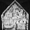
Against the inner face of the west gable of this chapel lies an armorial panel (NF73NE 1.06) with triangular head. It bears in relief in the dexter base a lymphad with rudder, central mast and sail set; above this is a hand couped bearing a wheel-cross. In the sinister base is a castle and above it a lion rampant; in the centre and surmounting the whole is a bird on a thistle slip. Beside the panel is a fragment of stone bearing six close set dog-tooth ornaments. (Fig. 122.)
RCAHMS 1928, visited 31 July 1924
OS map: South Uist l.
(1) Howmore was a parsonage pertaining to the Abbot of Iona. - Collect. de Rebus Alban, p. 3.
(2) Martin.
(3) Muir's Ecclesiological Notes, pp. 50, 51.
Reference (2001)
The remains of a group of churches and chapels stand at the N edge of the township of Howmore and about 750m from the W shore of South Uist. The name of the settlement incorporates the Old Norse haugr, 'a mound', but the location and age of this feature are not certain. The largest of the buildings, the Teampull Mor, whose E gable preserves two windows of 13th-century type, was the medieval parish church of South Uist, and Caibeal Dhiarmaid, whose footings lie in the burial-ground to the E of the church, was probably also of medieval date (i). A detached chapel to the S may be of post-medieval date, and another to the NE was probably the burial-aisle erected by John MacDonald of Clanranald (d.1574) (ii). A graveslab of late medieval type was recorded in the burial-ground in 1866 (iii), and a cross-marked slab lies in the ruin of Caibeal Dhiarmaid.
The cross-marked stone is a tapered slab of diorite, broken obliquely at the foot. It measures 0.68m by 0.36m at the head and is 75mm thick. On one face there is an equal-armed outline cross, 0.38m high, whose arms extend to the edges of the slab and whose foot is open. The surface is flaked but the cross has been defined by firm U-section grooves, and the armpits are slightly round and bevelled.
Footnotes:
(i) RCAHMS 1928, No.367. These were presumably the churches recorded by Martin (1934, 88) as being dedicated respectively to St Mary and St Columba.
(ii) A Cameron 1894, 170-1. A MacDonald armorial stone, which was stolen from this building in 1990 and recovered in 1995, is now in the heritage museum at Kildonnan. A smaller chapel of uncertain date, to the E of the burial-aisle, was removed between 1855 and 1866 (T S Muir 1885, 51).
(iii) T S Muir 1885, 51.
I Fisher 2001.
Project (6 September 2005 - 8 September 2005)
Scottish and Southern Electricity Plc commissioned SUAT Ltd to undertake an archaeological walkover survey on the route of overhead power cables running from Drimore to North Glendale on the island of South Uist, Western Isles. The survey was to be conducted in advance of refurbishment of the poles supporting the power cables, commencing at NGR NF 7690 4035 and proceeding southwards over a distance of approximately 25km. The work (SUAT site code SU01) was undertaken during the period 6th-8th September 2005 in varying weather conditions including both bright sunshine and rain squalls.
The requirement was to evaluate those sections of the line where groundworks or vehicle access would be necessary, assessing the possible impact of the work on known or previously unrecorded archaeological sites, as well as locating and describing the latter. Four previously unrecorded sets of features were noted on known sites, while a mitigation strategy agreed with SSE ensured that the refurbishment work was able to proceed without disturbance or damage to the archaeology of South Uist.
SUAT Ltd. 2005
Standing Building Recording (15 June 2014 - 16 June 2014)
NF 7581 3647 Recent PhD research, 15–16 June 2014, sought to characterise the lime mortars and masonry of the various surviving buildings of the chapel site of Howmore. Within the Clan Ranald Chapel, two contrasting shell-lime mortars were identified, wherein the mortar binding the masonry of the recess at the W end of the N wall, and the N end of the W wall, was found to contrast with that in the rest of the building.
This suggests that this NW feature is a later addition to the building. However, further scrutiny also revealed a substantial previously unrecorded lintel-roofed cavity forming part of the tomb recess to the W, within and beneath the NW corner of the building at current ground levels. With this in mind, the thicker masonry of the W end of the N wall of the building probably represents the structure of a Clan Ranald tomb of some importance. This structure may relate to the armorial stone found on this site and further structural comparisons with the 17th-century Clan Ranald recess-tomb at Arisaig are also apposite. Moreover, the in situ dog-tooth moulded stone is bonded to the masonry of this tomb structure. Both this stone and the matching ex situ dog-tooth moulded stone lying in the chapel, have 90° beds suggesting both are quoins rather than arch stones.
Further masonry details with imported geological provenances were noted within this and other buildings during this survey, and these have implications for our understanding of the development of the wider site. This site will appear as a case study in the contributor’s forthcoming PhD (arch) thesis at the University of Edinburgh.
Archive: Historic Scotland, RCAHMS and University of Edinburgh
Funder: University of Edinburgh
Mark Thacker – University of Edinburgh
(Source: DES)

