
St Kilda, Hirta, Tobar Childa


Hut Circle(S) (Prehistoric)
Site Name St Kilda, Hirta, Tobar Childa
Classification Hut Circle(S) (Prehistoric)
Canmore ID 9654
Site Number NF09NE 9
NGR NF 0995 9955
Datum OSGB36 - NGR
Permalink http://canmore.org.uk/site/9654


- Council Western Isles
- Parish Harris
- Former Region Western Isles Islands Area
- Former District Western Isles
- Former County Inverness-shire
NF09NE 9 0995 9955
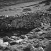
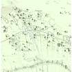
NF 0995 9955. Among the pre-1830 buildings or vestiges, noted on Macgregor's plan (see NF19NW 15), are 4 or 5 circular foundations which can only best be described as 'hut circles'; and in addition to these, at least another 4 have been identified. These are all generally located close together towards the western end of what must have been the early settlement of Village Bay; and all are above the dry-stone head-dyke, except for two outliers, one c.22m ENE of 'Calum Mor House' (NF 1009 9948), and the other some 165m, ESE beyond that hut (at NF 1022 9942). the main group of 5 or so is at NF 0995 9955, and others are at NF 1003 9958 and NF 1001 9956.
All these structures are formed by a circle of boulders and small stones 3.5m - 4.0m in diameter, attached to which are small boulder-formed field enclosures. No entrances were noted with certainty. It is also significant that this area is covered with loose boulder scree, not having been cleared for a considerable period. The resulting pattern is reminiscent of a 'Celtic' field system.
Visited by OS (J L D), 7 August 1967.
Field Visit (7 August 1967)
NF 0995 9955. Among the pre-1830 buildings or vestiges, noted on Macgregor's plan (see NF19NW 15), are 4 or 5 circular foundations which can only best be described as 'hut circles'; and in addition to these, at least another 4 have been identified. These are all generally located close together towards the western end of what must have been the early settlement of Village Bay; and all are above the dry-stone head-dyke, except for two outliers, one c.22m ENE of 'Calum Mor House' (NF 1009 9948), and the other some 165m, ESE beyond that hut (at NF 1022 9942). the main group of 5 or so is at NF 0995 9955, and others are at NF 1003 9958 and NF 1001 9956.
All these structures are formed by a circle of boulders and small stones 3.5m - 4.0m in diameter, attached to which are small boulder-formed field enclosures. No entrances were noted with certainty. It is also significant that this area is covered with loose boulder scree, not having been cleared for a considerable period. The resulting pattern is reminiscent of a 'Celtic' field system.
Visited by OS (J L D), 7 August 1967.

