
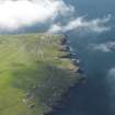
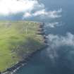
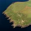
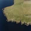
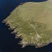
South Ronaldsay, Hoxa Head Lighthouse


Lighthouse (19th Century)
Site Name South Ronaldsay, Hoxa Head Lighthouse
Classification Lighthouse (19th Century)
Alternative Name(s) Scarf Skerry; Scapa Flow; Pentland Firth
Canmore ID 74483
Site Number ND49SW 25
NGR ND 40345 93170
Datum OSGB36 - NGR
Permalink http://canmore.org.uk/site/74483


- Council Orkney Islands
- Parish South Ronaldsay
- Former Region Orkney Islands Area
- Former District Orkney
- Former County Orkney
ND49SW 25 40345 93170
Lighthouse
(Flashing White, Red & Green) [NAT]
OS (GIS) MasterMap, April 2010.
Construction (1900)
Light established in 1900; built as an automatic.
K Allardyce 1998
Field Visit (August 1997)
A cast iron, gas-powered lighthouse of 1901 was built to guide ships into Scapa Flow. The superstructure has been removed, leaving a solid concrete plinth, which formed the base. It is located between two WWII searchlight emplacements (see SR24 (i)[ND49SW 27]). It lies 3m from the cliff edge and measures 4.4m by 5.2m. A modern lighthouse, with solar panels, has been built nearby.
Moore and Wilson, 1997
Coastal Zone Assessment Survey

