
Hoy, Rysa Lodge Battery


Radar Site (20th Century)
Site Name Hoy, Rysa Lodge Battery
Classification Radar Site (20th Century)
Canmore ID 270070
Site Number ND39NW 161.03
NGR ND 3032 9622
NGR Description c.ND 3032 9622
Datum OSGB36 - NGR
Permalink http://canmore.org.uk/site/270070


- Council Orkney Islands
- Parish Walls And Flotta
- Former Region Orkney Islands Area
- Former District Orkney
- Former County Orkney
ND39NW 161.03 c.3032 9622
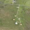
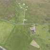
The platform and ramp for the mobile radar unit providing range and height finding information to the heavy anti-aircraft battery was situated about 150m S of the command centre (ND30323 96222). Both the platform and ramp
The platform and ramp with the Gl-mat of wires and posts is visible on vertical air photographs (LEU/UK 4, 7029-7030, flown 17 April 1948), also visible is the cable trench leading from the command centre.
Some of the posts with wire still attached can be seen in the field to the S.
Visited by RCAHMS (DE, GS), August 1999

