
Pricing Change
New pricing for orders of material from this site will come into place shortly. Charges for supply of digital images, digitisation on demand, prints and licensing will be altered.
Flotta, Golta, Roan Head, Z Battery


Anti Aircraft Battery (20th Century)
Site Name Flotta, Golta, Roan Head, Z Battery
Classification Anti Aircraft Battery (20th Century)
Alternative Name(s) Golta Peninsula
Canmore ID 104475
Site Number ND39NE 2
NGR ND 3688 9555
NGR Description Centred ND 3688 9555
Datum OSGB36 - NGR
Permalink http://canmore.org.uk/site/104475


- Council Orkney Islands
- Parish Walls And Flotta
- Former Region Orkney Islands Area
- Former District Orkney
- Former County Orkney
ND39NE 2.00 centred 3688 9555
ND39NE 2.01 centred ND 36801 95675 Military Camp
ND39NE 2.02 ND 37045 95581 Decoy site
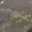
An anti-aircraft 'rocket' and camp site has been constructed on the brow of the hill at Golta, 1km E of the Flotta oil terminal. Consisting of several rows of small scale 'Nissen' style huts with corrugated iron roofs and rubble end walls, laid out in a regular pattern to imitate a military camp. These huts were probably used to store the 'rockets'. There are some concrete hut bases on the N-facing slope. Several pits for the 'rocket' launchers were also noted.
Visible on vertical air photographs (RAF/LEU/UK 4 7056-7), which also show an anti-aircraft site immediately to the E of the camp.
Visited by RCAHMS (GS, DE) May 1996.
Scheduled as 'Roan Head, World War II Z Battery and Light AA Battery... a Second World War Z Battery (multiple rocket launcher site) and decoy light anti-aircraft battery, and core associated buildings.
Information from Historic Scotland, scheduling document dated 25 March 2004.
The 'Z' battery of ammunition huts and rocket launcher bases is situated on the highest point on the Golta Peninsula in an area which has been heavily disturbed by peat digging. The small 'huts' are set in rows with many having a curved corrugated iron shed covered with an semi-circular concrete roof. The gable ends of the huts have infilled with water dipped bags of concrete which have been allowed to dry in situ. Many of the huts have had their roofs deliberately caved in and some have collapsed completely. The control building lies at the NW corner of the launching site.
Within the rows are two main connecting trackways, one leading NW to SE from the Military camp (ND39NE 2.01), and the other NE to SW, leading to the Decoy anti-aircraft battery (ND39NE 2.02), which cross at the centre of the battery..
Within each group of huts are the centrally placed circular concrete bases for the rocket launchers.
The 'Z' battery at Golta is one of the most complete remaining of this type in Scotland and is noted in documents from November 1942 held in the Public Record Office, as having 32 Unrotating Projectile launchers, which 'were not yet in action' (WO 166/7270). No War Office number was issued to this battery. The virtually complete battery is visible on 1948 RAF vertical air photographs (LEU/UK 4 , 7056-7057, flown 17 April 1948), however by this date nearly all of the huts had been removed.
Visited by RCAHMS (DE, GS, SW), August 1997
Field Visit (August 1997)
This area contains extensive structural remains associated with WWI and II military operations centred on the military camp at Golta and the coastal batteries at Roan Head. The main concentrations of these remains, which include an anti-aircraft rocket and dummy camp (ND39NE 2), three light anti-aircraft batteries (ND39NE 3, ND39NE 6 and ND39NE 7), a barrage balloon mooring position (ND39NE 4) and a large shed of pre-WWI date (ND39NE 5), lie outwith the area of this survey. Within the coastal zone lie the remains of a metalled trackway lined with concrete bollards and numerous small earthworks and concrete footings. Only the most substantial remains are described here:
i) (ND 3729 9590) A concrete shed, possibly a telegraphy station, is located on the beach. It measures 3m by 3m and stands to 3m high. It has a single door and window, both of which face inland.
ii) (ND 3686 9584) A rusted metal pipe, supported on a series of concrete pillars, issues from the coastal section and extends into the sea.
iii) (ND 3645 9581) The concrete footings of a building lie 15m from the coast edge. Aligned E-W, it measures 5m by 4m and has a set of two steps to its W end.
Moore and Wilson, 1997
Coastal Zone Assessment Survey

