
St John's Point


Promontory Fort (Period Unassigned), Rig And Furrow (Medieval) - (Post Medieval)
Site Name St John's Point
Classification Promontory Fort (Period Unassigned), Rig And Furrow (Medieval) - (Post Medieval)
Alternative Name(s) Can 027
Canmore ID 9369
Site Number ND37NW 1
NGR ND 3105 7515
Datum OSGB36 - NGR
Permalink http://canmore.org.uk/site/9369


- Council Highland
- Parish Canisbay
- Former Region Highland
- Former District Caithness
- Former County Caithness
ND37NW 1 3105 7515
(ND 3105 7515) Fort (NR)
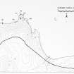
OS 1:10,000 map (1976).
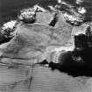
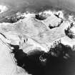
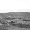
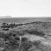
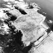
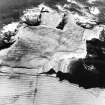
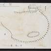
Fort, St John's Point: Across the landward end of the promontory of St John's Point, from cliff to cliff, has been dug a deep trench some 50ft in breadth, with a rampart some 10ft in height along the seaward side and a low mound crowning the counterscarp to landward. The rampart has probably borne a wall along its crest on the line of the present modern dyke, as a small portion of an ancient wall is visible beneath the latter near the W end of the defence. Some 50ft from the W extremity of the rampart there appears to have been an entrance. The area is some 10 acres in extent. Within it, and in the vicinity of the supposed site of the chapel (ND37SW 2) is elevated ground which is possibly an artificial mound.
Comparisons with similar works suggest an Iron Age date - even though possibly re-used by Viking or later medieval overlords (RCAHMS 1911).
RCAHMS 1911; R W Feachem 1963.
Dunmey is an alternative name for the promontory (and may have some relevance to the fort). The site is generally as described by the previous field investigator.
Orig Paroch Scot 1855.
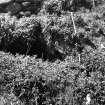
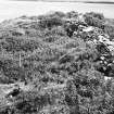
A fort consisting of a mutilated earth-and-stone rampart built between two geos and cutting off the fairly level promontory of St John's Point. The rampart varies between 12.0m in width and 3.0m high in the E, and 15.0m in width and 3.0m high in the W. There is no trace of a wall surmounting it as suggested by the RCAHMS. A gap towards the W end marks the entrance. About 10m outside the rampart is a denuded turf dyke spread to 3.5m, suggested by the RCAHMS to be an outer rampart, but this is partly if not wholly modern and contemporary with several acres of rig and furrow cultivation outside the fort. There is no definite evidence of a ditch. The area between the rampart and the turf dyke appears slightly hollowed, but this is partly caused by a drainage ditch which occupies it, and is partly a false impression gained by the position of the turf dyke. It is actually at the same level as the field to the S.
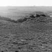
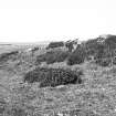
Within the fort, the promontory has been almost completely enclosed by a turf dyke, now spread to 2.5m and in places tumbled away over the cliffs. On the edge of the cliff in the E, about 100m NE of the E end of the fort rampart, this dyke stops short of a sub-rectangular grassy platform, some 9.0m NE-SW by 5.0m transversely, which appears to be the site of a building, although no structural details are visible. The dyke encloses rig and furrow cultivation, which is less well defined than that outside the fort.
Surveyed at 1:10,000.
Visited by OS (R D) 26 February 1965 and (A A) 20 April 1972.
A broad cliff promontory cut off by a massive rampart about 3m high, fronted by a U-sectioned ditch about 15m wide. The entrance may be represented by a gap towards the W end but this is not certain. A modern drystone dyke runs along the top of the rampart. No structures are visible within the rampart but against its rear is a well-constructed, rectangular building, locally said to be a chapel (ND37SW 2).
R G Lamb 1980.
An earthwork 10 acres in extent defined by a trench 16.5m wide and a rampart about 3m high. There is no evidence of occupation contemporary with the rampart, but there are traces of later occupation.
C E Batey 1982.
The report correctly states 'no definite evidence of a ditch' but the impression is that there has been a ditch.
Visited by OS (J M), 6 July 1982.
Project (1980 - 1982)
Note (19 February 2015 - 13 December 2016)
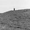
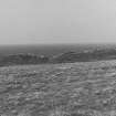
The large headland known as St John's Point is defended by a substantial rampart and ditch barring access from the S. The rampart is massive in Scottish terms, forming a bank some 12m in thickness at the base by 3m in height and is probably fronted by an equally broad ditch, though of the latter all that can be seen is a shallow hollow about 10m in breadth with a later turf field-bank extending along its counterscarp. The interior measures about 210m from N to S by up to 140m transversely (2.25ha), and is indented by deep geos along its seaward end to form three smaller promontories. Turf field-banks extend around the margin of the headland and much of its surface has been cultivated in rigs, but aerial photographs reveal traces of a ploughed-down arc of bank enclosing an area about 30m across in the angle between the cliffs on the E and the rampart on the S. This enclosure is the 'Grave Yard' annotated on the 1st edition OS 25-inch map (Caithness 1877, sheet 2.11), which places a cross marking the site of St John's Chapel at its centre. This attribution has been transposed to the remains of a building visible beneath the E end of a stone field-dyke that surmounts the rampart. In 1910 Alexander Curle noted that this was locally said to be a chapel, but he also observed that it was not correctly oriented and doubted the attribution (RCAHMS 1911, 20-1, no.56). Nevertheless, in 1919 John Nicolson uncovered the W gable end to reveal a central entrance and what he described as a slab-lined grave, with its head to the W and a reused cross-slab in one side (Nicolson 1922); the stratigraphic relationship between the chapel and the rampart was not recorded. Apart from a second compartment at the E end of this building, the only other feature visible within the interior of the fort are the remains of a rectangular building platform on the edge of the cliffs overlooking the N side of the small bay that cuts into the headland from the E (ND 31117 75151).
Information from An Atlas of Hillforts of Great Britain and Ireland – 13 December 2016. Atlas of Hillforts SC2833

